FAA INFORMATION EFFECTIVE 09 JULY 2026
Location
| FAA Identifier: | 21F |
| Lat/Long: | 33-13-40.3000N 098-08-47.2000W
33-13.671667N 098-08.786667W
33.2278611,-98.1464444
(estimated) |
| Elevation: | 1062 ft. / 324 m (estimated) |
| Variation: | 07E (1985) |
| From city: | 1 mile NE of JACKSBORO, TX |
| Time zone: | UTC -5 (UTC -6 during Standard Time) |
| Zip code: | 76458 |
Airport Operations
| Airport use: | Open to the public |
| Activation date: | 03/1968 |
| Control tower: | no |
| ARTCC: | FORT WORTH CENTER |
| FSS: | FORT WORTH FLIGHT SERVICE STATION |
| NOTAMs facility: | FTW (NOTAM-D service available) |
| Attendance: | UNATND |
| Wind indicator: | lighted |
| Segmented circle: | yes |
| Lights: | SS-SR |
| Beacon: | white-green (lighted land airport)
Operates sunset to sunrise. |
Airport Communications
| CTAF: | 122.9 |
| WX AWOS-3PT at XBP (16 nm E): | 119.225 (940-683-8027) |
Nearby radio navigation aids
| VOR radial/distance | | VOR name | | Freq | | Var |
|---|
| UKWr215/24.6 | | BOWIE VORTAC | | 117.15 | | 06E |
| MQPr337/31.0 | | MILLSAP VORTAC | | 117.70 | | 09E |
Airport Services
| Fuel available: | 100LL |
| Parking: | tiedowns |
| Bottled oxygen: | NONE |
| Bulk oxygen: | NONE |
Runway Information
Runway 18/36
| Dimensions: | 3220 x 75 ft. / 981 x 23 m |
| Surface: | asphalt, in good condition |
| Weight bearing capacity: | |
| Runway edge lights: | medium intensity |
| RUNWAY 18 | | RUNWAY 36 |
| Latitude: | 33-13.936885N | | 33-13.406852N |
| Longitude: | 098-08.765978W | | 098-08.805815W |
| Elevation: | 1022.0 ft. | | 1062.0 ft. |
| Traffic pattern: | left | | left |
| Runway heading: | 177 magnetic, 184 true | | 357 magnetic, 004 true |
| Markings: | basic, in fair condition | | basic, in fair condition |
| Obstructions: | 67 ft. pole, 1500 ft. from runway, 19:1 slope to clear
10 FT TREES, 20-199 FT DSTC, 115 L. | | 20 ft. trees, 201 ft. from runway, 30 ft. left of centerline
15 FT TREES, 0-199 FT DSTC. |
Airport Ownership and Management from official FAA records
| Ownership: | Publicly-owned |
| Owner: | CITY OF JACKSBORO
112 WEST BELKNAP
JACKSBORO, TX 76458
Phone 940-567-6321 |
| Manager: | JESSE MAXWELL
112 WEST BELKNAP
JACKSBORO, TX 76458
Phone 940-507-3147
FOR AFTR HRS ASSISTANCE, CTC CENTRAL DISPATCH 940-567-2161. |
Additional Remarks
| - | ARPT GATE LOCKED-COMBINATION 1581. |
| - | PILOT LOUNGE/RESTROOM ACCESS 1200. |
| - | BIRDS ON AND INVOF ARPT. |
| - | COURTESY CAR AVBL. NEXT TO FUEL PUMP, KEYBOX ON NW POLE, CODE 1581. CALL 940-507-3147 TO RES OR USE CAR. |
| - | 6 FT OPEN DRAINAGE DITCH NEAR RWY 18 THR, 81 FT EAST OF CNTRLN ON BOTH SIDES OF TWY. |
| - | 5 FT OPEN DRAINAGE DITCH 84 FT EAST OF RWY 18 CNTRLN ON BOTH SIDES OF RAMP SOUTH TWY. |
Instrument Procedures
There are no published instrument procedures at 21F.
Some nearby airports with instrument procedures:
KXBP - Bridgeport Municipal Airport (16 nm E)
KRPH - Graham Municipal Airport (22 nm W)
F35 - Possum Kingdom Airport (23 nm SW)
KMWL - Mineral Wells Regional Airport (27 nm S)
KLUD - Decatur Municipal Airport (28 nm E)
|
|

Road maps at:
MapQuest
Bing
Google
| Aerial photo |
|---|
WARNING: Photo may not be current or correct
 Photo courtesy of Civil Air Patrol
Photo taken 16-Sep-2006
Photo courtesy of Civil Air Patrol
Photo taken 16-Sep-2006
Do you have a better or more recent aerial photo of Jacksboro Municipal Airport that you would like to share? If so, please send us your photo.
|
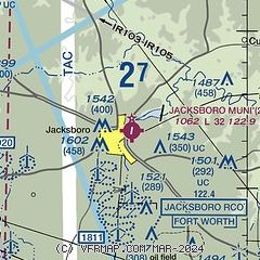
| Sectional chart |
|---|
|
| Airport distance calculator |
|---|
|
|
| Sunrise and sunset |
|---|
|
Times for 18-Jul-2026
| | Local
(UTC-5) | | Zulu
(UTC) |
|---|
| Morning civil twilight | | 06:09 | | 11:09 |
| Sunrise | | 06:37 | | 11:37 |
| Sunset | | 20:40 | | 01:40 |
| Evening civil twilight | | 21:08 | | 02:08 |
|
| Current date and time |
|---|
| Zulu (UTC) | 18-Jul-2026 07:37:38 |
|---|
| Local (UTC-5) | 18-Jul-2026 02:37:38 |
|---|
|
| METAR |
|---|
KXBP
16nm E | 180430Z AUTO 14004KT CLR 26/20 A3009 RMK AO2 T02610198 PWINO
|
KRPH
22nm W | 180715Z AUTO 15003KT 10SM CLR 25/21 A3005 RMK AO2 T02530210 $
|
KMWL
27nm S | 180653Z AUTO 15008KT 10SM CLR 25/21 A3005 RMK AO2 SLP161 T02500206
|
KLUD
28nm E | 118.22 940-927-2365
180455Z AUTO 15007KT 10SM CLR 28/20 A3008 RMK AO2 T02830200
|
K0F2
29nm NE | 180510Z AUTO 17004KT 10SM CLR 26/20 A3008 RMK AO2 T02550201
|
|
| TAF |
|---|
KAFW
45nm E | 180520Z 1806/1906 18011KT P6SM FEW060 FM181300 18012KT P6SM SCT025 FM181600 18016KT P6SM SCT060 FM190200 18007KT P6SM FEW250
|
KNFW
45nm SE | 1723/1823 18018G25KT 9999 SCT060 BKN250 QNH3000INS FM180300 17009KT 9999 FEW060 SCT250 QNH3005INS TEMPO 1811/1815 BKN012 FM181500 19012G23KT 9999 SCT060 BKN250 QNH3000INS AUTOMATED SENSOR METWATCH 1804 TIL 1811 TX34/1822Z TN25/1812Z FN20048
|
KFTW
46nm SE | 180520Z 1806/1906 18011KT P6SM FEW060 FM181300 18012KT P6SM SCT025 FM181600 18016KT P6SM SCT060 FM190200 18007KT P6SM FEW250
|
KSPS
49nm N | 180520Z 1806/1906 17008KT P6SM SCT050 PROB30 1809/1813 6SM -SHRA BR BKN015 FM181500 19016G24KT P6SM SCT040 SCT250 PROB30 1820/1824 4SM -TSRA BKN040CB FM190100 16012KT P6SM FEW060 SCT250
|
|
| NOTAMs |
|---|
NOTAMs are issued by the DoD/FAA and will open in a separate window not controlled by AirNav.
|
|


