FAA INFORMATION EFFECTIVE 19 FEBRUARY 2026
Location
| FAA Identifier: | 21W |
| Lat/Long: | 47-00-47.3000N 121-32-01.2000W
47-00.788333N 121-32.020000W
47.0131389,-121.5336667
(estimated) |
| Elevation: | 2650 ft. / 808 m (estimated) |
| Variation: | 19E (1995) |
| From city: | 10 miles SE of GREENWATER, WA |
| Time zone: | UTC -8 (UTC -7 during Daylight Saving Time) |
| Zip code: | 98022 |
Airport Operations
| Airport use: | Open to the public |
| Activation date: | 03/1997 |
| Control tower: | no |
| ARTCC: | SEATTLE CENTER |
| FSS: | SEATTLE FLIGHT SERVICE STATION |
| NOTAMs facility: | SEA (NOTAM-D service available) |
| Attendance: | UNATNDD |
| Wind indicator: | yes |
| Segmented circle: | no |
Airport Communications
Airport Services
Runway Information
Runway 15/33
| Dimensions: | 2875 x 30 ft. / 876 x 9 m |
| Surface: | asphalt, in fair condition |
| RUNWAY 15 | | RUNWAY 33 |
| Latitude: | 47-01.016428N | | 47-00.560888N |
| Longitude: | 121-32.112878W | | 121-31.926357W |
| Elevation: | 2558.0 ft. | | 2583.0 ft. |
| Traffic pattern: | left | | left |
| Runway heading: | 145 magnetic, 164 true | | 325 magnetic, 344 true |
| Markings: | numbers only, in fair condition | | numbers only, in fair condition |
| Obstructions: | 100 ft. trees, 1406 ft. from runway, 12:1 slope to clear
RWY 15 2 FT SIGN, 45 FT R & 11 FT FM THR; 65 FT TREES 87 FT R; GUARDRAIL & ROAD 55 FT L; 2 FT SIGN 45 FT L & 11 FT FM THR. | | 75 ft. trees, 965 ft. from runway, 10:1 slope to clear
HAS ROAD, GUARD & +95 FT TREES 90 FT R OF CNTRLN & 80 FT TREES 84 FT L OF CNTRLN. 2 FT SIGNS, 35 FT R & 43 FT L & 11 FT FM THR. |
Airport Ownership and Management from official FAA records
| Ownership: | Publicly-owned |
| Owner: | WSDOT AVIATION DIVISION
PO BOX 47312
OLYMPIA, WA 98504-7264
Phone 800-552-0666 |
| Manager: | JOHN WILSON
PO BOX 47312
OLYMPIA, WA 98504-7264
Phone 360-618-2477 |
Additional Remarks
| - | CLSD 1 OCT TO 1 JUN EXC FOR APPROVED MIL & PUBLIC SAFETY/LAW ENFORCEMENT HELI OPS. |
| - | GUARDRAIL AND ROAD RUNS FULL LEN OF EASTSIDE OF RWY. |
| - | CTN: MOUNTAINOUS TRRN SURROUNDS ARPT. |
| - | VEHICLES, PEDESTRIANS, & ANIMALS ON & INVOF RY. |
| - | USFS CAMPGROUNDS E & N OF RY. |
Instrument Procedures
There are no published instrument procedures at 21W.
Some nearby airports with instrument procedures:
KPLU - Pierce County Airport/Thun Field (31 nm W)
S50 - Auburn Municipal Airport (34 nm NW)
KTCM - McChord Field Airport (Joint Base Lewis-McChord) (39 nm W)
KRNT - Renton Municipal Airport (40 nm NW)
KELN - Bowers Field Airport (41 nm E)
|
|

Road maps at:
MapQuest
Bing
Google
| Aerial photo |
|---|
WARNING: Photo may not be current or correct
 Photo by Tom Jensen, Washington Pilots Association
Photo taken 15-Oct-2012
looking northwest.
Photo by Tom Jensen, Washington Pilots Association
Photo taken 15-Oct-2012
looking northwest.
Do you have a better or more recent aerial photo of Ranger Creek Airport that you would like to share? If so, please send us your photo.
|
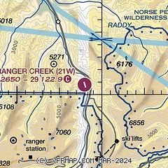
| Sectional chart |
|---|
|
| Airport distance calculator |
|---|
|
|
| Sunrise and sunset |
|---|
|
Times for 14-Mar-2026
| | Local
(UTC-7) | | Zulu
(UTC) |
|---|
| Morning civil twilight | | 06:52 | | 13:52 |
| Sunrise | | 07:22 | | 14:22 |
| Sunset | | 19:09 | | 02:09 |
| Evening civil twilight | | 19:39 | | 02:39 |
|
| Current date and time |
|---|
| Zulu (UTC) | 14-Mar-2026 09:59:46 |
|---|
| Local (UTC-7) | 14-Mar-2026 02:59:46 |
|---|
|
| METAR |
|---|
KSMP
18nm NE | 140856Z AUTO VRB06KT 1/2SM -SN FZFG M03/M03 A2978 RMK AO2 SNB04 SLP733 P0002 60006 I3000 T10281028 55000 $
|
KPLU
31nm W | 140955Z AUTO 00000KT 3SM -SN OVC003 01/01 A3002 RMK AO2
|
|
| TAF |
|---|
KTCM
39nm W | 140500Z 1405/1511 VRB05KT 4800 -RASN OVC002 620109 QNH2995INS BECMG 1410/1411 20006KT 6000 -SHRASN BKN010 OVC020 610105 QNH3002INS BECMG 1415/1416 19008KT 9999 NSW SCT040 QNH3006INS BECMG 1420/1421 27010KT 9999 FEW040 SCT200 QNH3029INS BECMG 1506/1507 18008KT 9999 BKN120 QNH3045INS TX09/1423Z TN01/1414Z
|
KSEA
41nm NW | 140703Z 1407/1512 VRB03KT 3SM BR FEW004 SCT010 OVC040 FM140800 21003KT 1/2SM FG BKN003 OVC007 FM141400 17007KT 5SM BR VCSH SCT007 OVC015 FM141700 18006KT P6SM SCT015 BKN050 FM142100 13007KT P6SM BKN100
|
KGRF
42nm W | 140500Z 1405/1511 30004KT 4800 -RA BR FEW005 OVC015 620159 QNH3000INS TEMPO 1405/1409 BKN005 BECMG 1409/1410 22005KT 9000 BR VCSH BKN010 OVC025 610209 QNH2995INS BECMG 1411/1412 25006KT 9999 NSW SCT015 QNH2999INS BECMG 1419/1420 27010KT 9999 FEW200 510102 QNH3022INS TEMPO 1422/1501 27010G20KT 520003 TX09/1500Z TN00/1415Z LAST NO AMDS AFT 1408 NEXT 1608
|
KBFI
45nm NW | 140703Z 1407/1506 VRB03KT 6SM BR OVC008 FM140800 17003KT 1SM BR BKN005 OVC010 FM141500 18007KT 6SM BR VCSH SCT010 OVC020 FM141800 18007KT P6SM SCT020 BKN050 FM142100 15005KT P6SM BKN100
|
|
| NOTAMs |
|---|
NOTAMs are issued by the DoD/FAA and will open in a separate window not controlled by AirNav.
|
|

