FAA INFORMATION EFFECTIVE 16 APRIL 2026
Location
| FAA Identifier: | 2B1 |
| Lat/Long: | 41-41-07.0000N 070-24-08.1000W
41-41.116667N 070-24.135000W
41.6852778,-70.4022500
(estimated) |
| Elevation: | 103 ft. / 31 m (estimated) |
| Variation: | 16W (1985) |
| From city: | 5 miles SE of MARSTON MILLS, MA |
| Time zone: | UTC -4 (UTC -5 during Standard Time) |
| Zip code: | 02648 |
Airport Operations
| Airport use: | Open to the public |
| Activation date: | 04/1940 |
| Control tower: | no |
| ARTCC: | BOSTON CENTER |
| FSS: | BRIDGEPORT FLIGHT SERVICE STATION |
| NOTAMs facility: | BDR (NOTAM-D service available) |
| Attendance: | DAYLIGHT HOURS |
| Pattern altitude: | 803 ft. MSL |
| Wind indicator: | yes |
| Segmented circle: | no |
Airport Communications
| CTAF: | 122.9 |
| BOSTON APPROACH: | 118.2 |
| BOSTON DEPARTURE: | 118.2 |
| WX ASOS at HYA (6 nm E): | PHONE 508-862-2601 |
| WX ASOS at FMH (6 nm W): | PHONE 508-968-6562 |
| WX ASOS at CQX (18 nm E): | 135.875 (508-945-5034) |
| WX ASOS at PYM (20 nm NW): | 135.625 (508-319-1421) |
| WX ASOS at MVY (20 nm SW): | 126.25 (508-696-6988) |
Nearby radio navigation aids
| VOR radial/distance | | VOR name | | Freq | | Var |
|---|
| MVYr044/19.8 | | MARTHAS VINEYARD VOR/DME | | 114.50 | | 15W |
| LFVr235/25.7 | | MARCONI VOR/DME | | 114.70 | | 16W |
| ACKr340/29.5 | | NANTUCKET VOR/DME | | 116.20 | | 15W |
| NDB name | | Hdg/Dist | | Freq | | Var | | ID |
|---|
| NAUSET | | 285/18.6 | | 279 | | 16W | | CQX | -.-. --.- -..- |
| PROVINCETOWN | | 215/24.4 | | 389 | | 16W | | PVC | .--. ...- -.-. |
Airport Services
| Fuel available: | 100LL |
| Parking: | hangars and tiedowns |
| Airframe service: | MINOR |
| Powerplant service: | MINOR |
Runway Information
Runway 9/27
| Dimensions: | 2700 x 60 ft. / 823 x 18 m |
| Surface: | turf, in good condition |
| RUNWAY 9 | | RUNWAY 27 |
| Latitude: | 41-41.055555N | | 41-41.178257N |
| Longitude: | 070-24.453857W | | 070-23.937093W |
| Elevation: | 97.8 ft. | | 95.3 ft. |
| Traffic pattern: | left | | left |
| Obstructions: | 5 ft. trees, 24 ft. from runway, 75 ft. right of centerline, 5:1 slope to clear | | 30 ft. trees, 148 ft. from runway, 60 ft. right of centerline, 5:1 slope to clear |
Runway 17/35
| Dimensions: | 2060 x 60 ft. / 628 x 18 m |
| Surface: | turf, in good condition |
| RUNWAY 17 | | RUNWAY 35 |
| Latitude: | 41-41.268268N | | 41-41.003185N |
| Longitude: | 070-24.233773W | | 070-24.062942W |
| Elevation: | 102.8 ft. | | 89.1 ft. |
| Traffic pattern: | left | | left |
| Obstructions: | 18 ft. trees, 72 ft. from runway, 60 ft. right of centerline, 4:1 slope to clear | | 9 ft. pline, 36 ft. from runway, 75 ft. right of centerline, 4:1 slope to clear
AND TREES. |
Runway 5/23
| Dimensions: | 2035 x 50 ft. / 620 x 15 m |
| Surface: | turf, in good condition |
| RUNWAY 5 | | RUNWAY 23 |
| Latitude: | 41-40.968793N | | 41-41.224140N |
| Longitude: | 070-24.154057W | | 070-23.926715W |
| Elevation: | 91.0 ft. | | 94.1 ft. |
| Traffic pattern: | left | | left |
| Obstructions: | 13 ft. trees, 40 ft. from runway, 125 ft. both sides of centerline, 3:1 slope to clear | | 50 ft. trees, 200 ft. from runway, 125 ft. right of centerline, 4:1 slope to clear |
Airport Ownership and Management from official FAA records
| Ownership: | Publicly-owned |
| Owner: | TOWN OF BARNSTABLE
367 MAIN ST
HYANNIS, MA 02601
Phone 508-862-4000 |
| Manager: | CHRISTOPHER SIDERWICZ
1000 RACE LANE
MARSTONS MILLS, MA 02648
Phone 508-428-8732 |
Additional Remarks
| - | BE AWARE OF HIGH-SPD MIL JET & HVY HEL TFC VCNTY CAPE COD CGAS. |
| - | BE ALERT FOR RADIO CTL AIRPLANES NE CORNER AIRFIELD. |
| - | BANNER TOW OPNS IN PROG JUN THRU AUG, NORTH SIDE OF AIRFIELD. |
| - | GLDR TOW OPNS DRG DALGT HRS. |
| - | PPR FOR RWY 05/23 OPNS. |
| - | PAJA ON FIELD. |
| - | HEL OPNS CTC AMGR FOR ARPT PROCS/PRKG. |
| - | FOR CD CTC BOSTON APCH AT 603-594-5554. |
Instrument Procedures
There are no published instrument procedures at 2B1.
Some nearby airports with instrument procedures:
KHYA - Cape Cod Gateway Airport (6 nm E)
KFMH - Cape Cod Coast Guard Air Station (6 nm W)
5B6 - Falmouth Airpark (9 nm SW)
KCQX - Chatham Municipal Airport (18 nm E)
KPYM - Plymouth Municipal Airport (20 nm NW)
KMVY - Martha's Vineyard Airport (20 nm SW)
|
|

Road maps at:
MapQuest
Bing
Google
| Aerial photo |
|---|
WARNING: Photo may not be current or correct
 Taken late August 2013
looking northeast.
Taken late August 2013
looking northeast.
Do you have a better or more recent aerial photo of Cape Cod Airport that you would like to share? If so, please send us your photo.
|
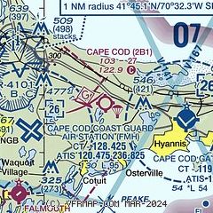
| Sectional chart |
|---|
|
| Airport distance calculator |
|---|
|
|
| Sunrise and sunset |
|---|
|
Times for 02-May-2026
| | Local
(UTC-4) | | Zulu
(UTC) |
|---|
| Morning civil twilight | | 05:08 | | 09:08 |
| Sunrise | | 05:38 | | 09:38 |
| Sunset | | 19:39 | | 23:39 |
| Evening civil twilight | | 20:10 | | 00:10 |
|
| Current date and time |
|---|
| Zulu (UTC) | 02-May-2026 07:05:38 |
|---|
| Local (UTC-4) | 02-May-2026 03:05:38 |
|---|
|
| METAR |
|---|
KFMH
6nm SW | 020656Z 23004KT 10SM CLR 08/05 A2991
|
KHYA
6nm E | 020656Z AUTO 24007KT 10SM CLR 09/04 A2988 RMK AO2 SLP120 T00890044 $
|
KCQX
18nm E | 020652Z AUTO 21005KT 10SM CLR 09/07 A2991 RMK AO2 SLP130 T00940067
|
KMVY
20nm SW | 020653Z AUTO 22005KT 10SM CLR 07/04 A2990 RMK AO2 SLP126 T00720044
|
|
| TAF |
|---|
KFMH
6nm SW | 020520Z 0206/0306 24010KT P6SM SKC FM021300 21005KT P6SM BKN090 FM021500 20007KT P6SM OVC040 PROB30 0216/0221 4SM -SHRA OVC030 FM022100 19008KT P6SM -SHRA OVC040 FM030000 20004KT 4SM -RA OVC025 FM030300 31002KT 2SM -RA BR OVC003 AMD NOT SKED
|
KHYA
6nm E | 020520Z 0206/0306 22008KT P6SM SKC FM021300 21005KT P6SM BKN090 FM021500 20007KT P6SM OVC040 PROB30 0216/0221 4SM -SHRA OVC030 FM022100 19007KT 6SM -SHRA OVC040 FM030000 VRB03KT 6SM -RA HZ BR OVC015 FM030300 00000KT 4SM -RA BR OVC007
|
|
| NOTAMs |
|---|
NOTAMs are issued by the DoD/FAA and will open in a separate window not controlled by AirNav.
|
|

