FAA INFORMATION EFFECTIVE 02 OCTOBER 2025
Location
| FAA Identifier: | 3Y3 |
| Lat/Long: | 41-21-46.1000N 094-01-16.3000W
41-21.768333N 094-01.271667W
41.3628056,-94.0211944
(estimated) |
| Elevation: | 1115.5 ft. / 340.0 m (surveyed) |
| Variation: | 02E (2010) |
| From city: | 2 miles N of WINTERSET, IA |
| Time zone: | UTC -5 (UTC -6 during Standard Time) |
| Zip code: | 50273 |
Airport Operations
| Airport use: | Open to the public |
| Activation date: | 01/1970 |
| Control tower: | no |
| ARTCC: | MINNEAPOLIS CENTER |
| FSS: | FORT DODGE FLIGHT SERVICE STATION |
| NOTAMs facility: | FOD (NOTAM-D service available) |
| Attendance: | MON-FRI 0800-1700, ALL SAT-SUN ON CALL |
| Pattern altitude: | 1915.5 ft. MSL |
| Wind indicator: | lighted |
| Segmented circle: | no |
| Lights: | ACTVT MIRL RY 14/32 & PAPI RYS 14 & 32 - CTAF. |
| Beacon: | white-green (lighted land airport)
Operates sunset to sunrise. |
Airport Communications
| CTAF/UNICOM: | 122.7 |
| DES MOINES APPROACH: | 123.9 |
| DES MOINES DEPARTURE: | 123.9 |
| WX ASOS at DSM (19 nm NE): | 119.55 (515-218-1035) |
Nearby radio navigation aids
| VOR radial/distance | | VOR name | | Freq | | Var |
|---|
| DSMr248/17.4 | | DES MOINES VORTAC | | 117.50 | | 07E |
Airport Services
| Fuel available: | 100LL JET-A |
| Parking: | hangars and tiedowns |
| Airframe service: | MAJOR |
| Powerplant service: | MAJOR |
| Bottled oxygen: | NONE |
| Bulk oxygen: | NONE |
Runway Information
Runway 14/32
| Dimensions: | 3002 x 50 ft. / 915 x 15 m |
| Surface: | asphalt, in good condition |
| Weight bearing capacity: | |
| Runway edge lights: | non-standard
MIRL - RWY 14/32 ENDS HAVE SIX THLD LGTS AND ALL WHITE LENSES ALONG RWY LEN. |
| RUNWAY 14 | | RUNWAY 32 |
| Latitude: | 41-21.965163N | | 41-21.572028N |
| Longitude: | 094-01.471078W | | 094-01.073435W |
| Elevation: | 1115.5 ft. | | 1093.8 ft. |
| Traffic pattern: | left | | left |
| Runway heading: | 141 magnetic, 143 true | | 321 magnetic, 323 true |
| Displaced threshold: | 175 ft. | | no |
| Markings: | nonprecision, in good condition | | nonprecision, in good condition |
| Visual slope indicator: | 2-light PAPI on left (3.00 degrees glide path) | | 2-light PAPI on left (3.00 degrees glide path) |
| Touchdown point: | yes, no lights | | yes, no lights |
| Obstructions: | 15 ft. road, 200 ft. from runway, 45 ft. right of centerline, 1:1 slope to clear
15 FT ROAD 140 FT FM RY END | | 20 ft. tree, 603 ft. from runway, 210 ft. right of centerline, 20:1 slope to clear |
Airport Ownership and Management from official FAA records
| Ownership: | Publicly-owned |
| Owner: | WNTRSET ARPT AUTH
3405 NORTH 8TH AVENUE
WINTERSET, IA 50273
Phone 515-979-7250
WINTERSET AIRPORT AUTHORITY |
| Manager: | RANDY BENGE
3405 NORTH 8TH AVE
WINTERSET, IA 50273
Phone 515-979-7250
WINTERSET.APMANAGER@GMAIL.COM |
Additional Remarks
| - | ULTRALIGHT ACT ON & INVOF ARPT. |
| - | RWY 32 END SAFETY AREA EXTDS 240 FT; SHARP DROP AT THAT POINT. |
| - | INADQT CLNC FOR HLDG ON THE TARND AT THE THR OF RWY 32. |
| - | RWY 32 IS CALM WIND RWY. |
| - | FOR CD CTC DES MOINES ATCT AT 515-974-8016. |
Instrument Procedures
NOTE: All procedures below are presented as PDF files. If you need a reader for these files, you should download the free Adobe Reader.NOT FOR NAVIGATION. Please procure official charts for flight.
FAA instrument procedures published for use from 02 October 2025 at 0901Z to 30 October 2025 at 0900z.
IAPs - Instrument Approach Procedures |
|---|
| RNAV (GPS) RWY 14 | |
download (173KB) |
| RNAV (GPS) RWY 32 | |
download (161KB) |
| NOTE: Special Take-Off Minimums/Departure Procedures apply | |
download (233KB) |
Other nearby airports with instrument procedures:
KDSM - Des Moines International Airport (19 nm NE)
KGFZ - Greenfield Municipal Airport (19 nm W)
I75 - Osceola Municipal Airport (24 nm SE)
KCSQ - Creston Municipal Airport (26 nm SW)
KGCT - Guthrie County Regional Airport (27 nm NW)
|
|

Road maps at:
MapQuest
Bing
Google
| Aerial photo |
|---|
WARNING: Photo may not be current or correct
 Photo by Michael Sawyer
Photo taken 20-Sep-2013
looking southeast.
Photo by Michael Sawyer
Photo taken 20-Sep-2013
looking southeast.
Do you have a better or more recent aerial photo of Winterset Municipal Airport that you would like to share? If so, please send us your photo.
|
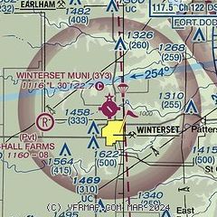
| Sectional chart |
|---|
|
| Airport distance calculator |
|---|
|
|
| Sunrise and sunset |
|---|
|
Times for 08-Oct-2025
| | Local
(UTC-5) | | Zulu
(UTC) |
|---|
| Morning civil twilight | | 06:54 | | 11:54 |
| Sunrise | | 07:21 | | 12:21 |
| Sunset | | 18:46 | | 23:46 |
| Evening civil twilight | | 19:14 | | 00:14 |
|
| Current date and time |
|---|
| Zulu (UTC) | 08-Oct-2025 22:43:53 |
|---|
| Local (UTC-5) | 08-Oct-2025 17:43:53 |
|---|
|
| METAR |
|---|
KDSM
19nm NE | 082154Z 11008KT 10SM FEW065 21/05 A3032 RMK AO2 SLP268 T02060050
|
KI75
24nm SE | 082215Z AUTO 10004KT 10SM CLR 21/05 A3032 RMK AO2 T02110047
|
KCSQ
26nm SW | 082215Z AUTO 15007G12KT 10SM CLR 20/06 A3030 RMK AO2
|
KIKV
28nm NE | 082215Z AUTO VRB03KT 10SM CLR 20/05 A3033 RMK AO2
|
KPRO
29nm N | 082215Z AUTO 12008KT 10SM CLR 20/07 A3029 RMK AO2 T02030066
|
KCNC
36nm SE | 082215Z AUTO 09006KT 7SM CLR 20/05 A3031 RMK AO2
|
|
| TAF |
|---|
KDSM
19nm NE | 081720Z 0818/0918 10005KT P6SM SKC FM091200 14008KT P6SM SCT250
|
|
| NOTAMs |
|---|
NOTAMs are issued by the DoD/FAA and will open in a separate window not controlled by AirNav.
|
|

