FAA INFORMATION EFFECTIVE 11 JUNE 2026
Location
| FAA Identifier: | CNC |
| Lat/Long: | 41-01-10.6000N 093-21-34.8000W
41-01.176667N 093-21.580000W
41.0196111,-93.3596667
(estimated) |
| Elevation: | 1050.5 ft. / 320.2 m (surveyed) |
| Variation: | 03E (1995) |
| From city: | 3 miles W of CHARITON, IA |
| Time zone: | UTC -5 (UTC -6 during Standard Time) |
| Zip code: | 50049 |
Airport Operations
| Airport use: | Open to the public |
| Activation date: | 04/1947 |
| Control tower: | no |
| ARTCC: | MINNEAPOLIS CENTER |
| FSS: | FORT DODGE FLIGHT SERVICE STATION |
| NOTAMs facility: | CNC (NOTAM-D service available) |
| Attendance: | ON CALL
FOR ASSISTANCE CALL 641-774-5083. |
| Wind indicator: | lighted |
| Segmented circle: | yes |
| Lights: | MIRL RYS 17/35 & 10/28 PRESET ON LOW INTST; TO INCR INTST & ACTVT REIL RYS 17; 35; 10 & 28; PAPI RYS 17; 35 & 28 - CTAF. |
| Beacon: | white-green (lighted land airport)
Operates sunset to sunrise. |
Airport Communications
| CTAF/UNICOM: | 122.8 |
| WX AWOS-3: | 125.525 (641-774-5645) |
| DES MOINES APPROACH: | 123.9 [0500-2330] |
| DES MOINES DEPARTURE: | 123.9 [0500-2330] |
| WX AWOS-3 at I75 (15 nm W): | 120.975 (641-342-1422) |
Nearby radio navigation aids
| VOR radial/distance | | VOR name | | Freq | | Var |
|---|
| DSMr146/28.3 | | DES MOINES VORTAC | | 117.50 | | 07E |
| LMNr040/37.5 | | LAMONI VOR/DME | | 116.70 | | 07E |
Airport Services
| Fuel available: | 100LL |
| Parking: | hangars |
| Airframe service: | NONE |
| Powerplant service: | NONE |
| Bottled oxygen: | NONE |
| Bulk oxygen: | NONE |
Runway Information
Runway 10/28
| Dimensions: | 4000 x 75 ft. / 1219 x 23 m |
| Surface: | concrete/wired/combed, in good condition |
| Weight bearing capacity: | |
| Runway edge lights: | medium intensity |
| RUNWAY 10 | | RUNWAY 28 |
| Latitude: | 41-01.246077N | | 41-01.112292N |
| Longitude: | 093-21.807767W | | 093-20.956078W |
| Elevation: | 1045.6 ft. | | 1033.9 ft. |
| Traffic pattern: | left | | left |
| Runway heading: | 099 magnetic, 102 true | | 279 magnetic, 282 true |
| Markings: | nonprecision, in fair condition | | nonprecision, in fair condition |
| Visual slope indicator: | 2-box VASI on left (3.00 degrees glide path) | | 2-light PAPI on left (3.00 degrees glide path) |
| Runway end identifier lights: | yes | | yes |
| Touchdown point: | yes, no lights | | yes, no lights |
| Obstructions: | none
+18' ROAD AT 650' GLIDESLOPE 25:1. | | 21 ft. tree, 948 ft. from runway, 31 ft. right of centerline, 35:1 slope to clear |
Runway 17/35
| Dimensions: | 2800 x 75 ft. / 853 x 23 m |
| Surface: | concrete, in good condition |
| Weight bearing capacity: | |
| Runway edge lights: | medium intensity |
| RUNWAY 17 | | RUNWAY 35 |
| Latitude: | 41-01.405307N | | 41-00.944207N |
| Longitude: | 093-21.864055W | | 093-21.864735W |
| Elevation: | 1037.8 ft. | | 1049.8 ft. |
| Traffic pattern: | left | | left |
| Runway heading: | 177 magnetic, 180 true | | 357 magnetic, 000 true |
| Markings: | nonprecision, in fair condition | | nonprecision, in fair condition |
| Visual slope indicator: | 2-light PAPI on left | | 2-light PAPI on left |
| Runway end identifier lights: | yes | | yes |
| Touchdown point: | yes, no lights | | yes, no lights |
| Obstructions: | none | | 15 ft. road, 500 ft. from runway, 20:1 slope to clear |
Airport Ownership and Management from official FAA records
| Ownership: | Publicly-owned |
| Owner: | CITY OF CHARITON
115 SOUTH MAIN
CHARITON, IA 50049
Phone 641-774-5991 |
| Manager: | CHRISTY METZGER
115 SOUTH MAIN
CHARITON, IA 50049
Phone 641-774-5991 |
Additional Remarks
| - | FOR CD CTC DES MOINES ATCT AT 515-974- 8016. |
Instrument Procedures
NOTE: All procedures below are presented as PDF files. If you need a reader for these files, you should download the free Adobe Reader.NOT FOR NAVIGATION. Please procure official charts for flight.
FAA instrument procedures published for use from 11 June 2026 at 0901Z to 09 July 2026 at 0900z.
IAPs - Instrument Approach Procedures |
|---|
| RNAV (GPS) RWY 10 | |
download (209KB) |
| RNAV (GPS) RWY 17 | |
download (192KB) |
| NOTE: Special Alternate Minimums apply | |
download (24KB) |
| NOTE: Special Take-Off Minimums/Departure Procedures apply | |
download (158KB) |
Other nearby airports with instrument procedures:
I75 - Osceola Municipal Airport (15 nm W)
KOXV - Knoxville Municipal Airport (20 nm NE)
4C8 - Albia Municipal Airport (27 nm E)
KTVK - Centerville Municipal Airport (29 nm SE)
KPEA - Pella Municipal Airport (30 nm NE)
|
|

Road maps at:
MapQuest
Bing
Google
| Aerial photo |
|---|
WARNING: Photo may not be current or correct

Do you have a better or more recent aerial photo of Chariton Municipal Airport that you would like to share? If so, please send us your photo.
|
| Sectional chart |
|---|
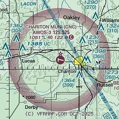
|
| Airport distance calculator |
|---|
|
|
| Sunrise and sunset |
|---|
|
Times for 12-Jun-2026
| | Local
(UTC-5) | | Zulu
(UTC) |
|---|
| Morning civil twilight | | 05:08 | | 10:08 |
| Sunrise | | 05:42 | | 10:42 |
| Sunset | | 20:45 | | 01:45 |
| Evening civil twilight | | 21:18 | | 02:18 |
|
| Current date and time |
|---|
| Zulu (UTC) | 12-Jun-2026 10:52:11 |
|---|
| Local (UTC-5) | 12-Jun-2026 05:52:11 |
|---|
|
| METAR |
|---|
| KCNC | 121035Z AUTO 23005KT 10SM CLR 13/13 A2996 RMK AO2
|
KI75
15nm W | 121035Z AUTO 24005KT 7SM CLR 14/11 A2997 RMK AO2 T01400108
|
KOXV
19nm NE | 121035Z AUTO 25005KT 10SM CLR 14/11 A2995 RMK AO2
|
|
| TAF |
|---|
KDSM
34nm NW | 120520Z 1206/1306 28005KT P6SM SKC FM122200 21007KT P6SM SKC
|
KOTM
41nm E | 120520Z 1206/1306 27006KT P6SM SKC FM130000 21005KT P6SM SKC
|
|
| NOTAMs |
|---|
NOTAMs are issued by the DoD/FAA and will open in a separate window not controlled by AirNav.
|
|

