FAA INFORMATION EFFECTIVE 16 APRIL 2026
Location
| FAA Identifier: | GFZ |
| Lat/Long: | 41-19-38.0000N 094-26-42.6000W
41-19.633333N 094-26.710000W
41.3272222,-94.4451667
(estimated) |
| Elevation: | 1363.6 ft. / 415.6 m (surveyed) |
| Variation: | 04E (1995) |
| From city: | 2 miles NE of GREENFIELD, IA |
| Time zone: | UTC -5 (UTC -6 during Standard Time) |
| Zip code: | 50849 |
Airport Operations
| Airport use: | Open to the public |
| Activation date: | 02/1958 |
| Control tower: | no |
| ARTCC: | MINNEAPOLIS CENTER |
| FSS: | FORT DODGE FLIGHT SERVICE STATION |
| NOTAMs facility: | FOD (NOTAM-D service available) |
| Attendance: | UNATNDD |
| Wind indicator: | lighted, WIND INDICATOR LIGHTS ACTIVATED VIA 122.9. |
| Segmented circle: | no |
| Lights: | ACTVT MIRL RY 7/25 - CTAF. MIRL RY 07/25 PRESET ON LOW INTST; TO INCR INTST - CTAF. |
| Beacon: | white-green (lighted land airport)
Operates sunset to sunrise. |
Airport Communications
| CTAF: | 122.9 |
| WX AWOS-3 at CSQ (19 nm S): | 124.75 (641-782-6286) |
- APCH/DEP SVC PRVDD BY MINNEAPOLIS ARTCC ON FREQS 125.65/306.950 (DES MOINES RCAG).
Nearby radio navigation aids
| VOR radial/distance | | VOR name | | Freq | | Var |
|---|
| DSMr253/36.5 | | DES MOINES VORTAC | | 117.50 | | 07E |
Airport Services
| Fuel available: | 100LL |
| Parking: | tiedowns |
| Bottled oxygen: | NONE |
| Bulk oxygen: | NONE |
Runway Information
Runway 7/25
| Dimensions: | 3400 x 60 ft. / 1036 x 18 m |
| Surface: | concrete, in good condition |
| Weight bearing capacity: | |
| Runway edge lights: | medium intensity |
| RUNWAY 7 | | RUNWAY 25 |
| Latitude: | 41-19.590795N | | 41-19.697935N |
| Longitude: | 094-26.958653W | | 094-26.229695W |
| Elevation: | 1359.1 ft. | | 1363.6 ft. |
| Traffic pattern: | left | | left |
| Runway heading: | 074 magnetic, 078 true | | 254 magnetic, 258 true |
| Markings: | nonprecision, in good condition | | nonprecision, in good condition |
| Touchdown point: | yes, no lights | | yes, no lights |
Runway 14/32
| Dimensions: | 2500 x 50 ft. / 762 x 15 m |
| Surface: | concrete, in good condition |
| Weight bearing capacity: | | PCN 6 /R/D/W/U | | Single wheel: | 7.0 |
|
| RUNWAY 14 | | RUNWAY 32 |
| Latitude: | 41-19.780470N | | 41-19.454617N |
| Longitude: | 094-27.034547W | | 094-26.701333W |
| Elevation: | 1356.6 ft. | | 1362.2 ft. |
| Traffic pattern: | left | | left |
| Runway heading: | 138 magnetic, 142 true | | 318 magnetic, 322 true |
| Displaced threshold: | no | | 250 ft. |
| Declared distances: | TORA:2250 TODA:2250 ASDA:2500 LDA:2500 | | TORA:2500 TODA:2500 ASDA:2500 LDA:2250 |
| Markings: | basic, in good condition | | basic, in good condition |
| Runway end identifier lights: | no | | no |
| Touchdown point: | yes, no lights | | yes, no lights |
| Obstructions: | none | | 16 ft. road, 320 ft. from runway, 250 ft. right of centerline, 7:1 slope to clear
18' HANGAR 50' FROM RWY END AND 250' RIGHT |
Airport Ownership and Management from official FAA records
| Ownership: | Publicly-owned |
| Owner: | CITY OF GREENFIELD
202 SOUTH 1ST STREET
GREENFIELD, IA 50849
Phone 641-743-2183 |
| Manager: | BRIAN HOADLEY
202 SOUTH 1ST STREET
GREENFIELD, IA 50849
Phone 641-743-6384 |
Additional Remarks
| - | PHONE ON ARPT. |
| - | INADQT CLNC FOR HLDG ON TURNAROUND AT THLD OF RWY 14. |
| - | RY 25 IS CALM WIND RY. |
| - | FOR CD CTC MINNEAPOLIS ARTCC AT 651-463-5588. |
Instrument Procedures
NOTE: All procedures below are presented as PDF files. If you need a reader for these files, you should download the free Adobe Reader.NOT FOR NAVIGATION. Please procure official charts for flight.
FAA instrument procedures published for use from 16 April 2026 at 0901Z to 14 May 2026 at 0900Z.
IAPs - Instrument Approach Procedures |
|---|
| RNAV (GPS) RWY 07 | |
download (220KB) |
| RNAV (GPS) RWY 25 | |
download (203KB) |
| NOTE: Special Take-Off Minimums/Departure Procedures apply | |
download (158KB) |
Other nearby airports with instrument procedures:
KCSQ - Creston Municipal Airport (19 nm S)
3Y3 - Winterset Municipal Airport (19 nm E)
KGCT - Guthrie County Regional Airport (22 nm N)
KCRZ - Corning Municipal Airport (24 nm SW)
KAIO - Atlantic Municipal Airport (28 nm W)
|
|

Road maps at:
MapQuest
Bing
Google
| Aerial photo |
|---|
WARNING: Photo may not be current or correct
 Photo by Iden Mersereau
Photo taken 09-Sep-2018
looking east.
Photo by Iden Mersereau
Photo taken 09-Sep-2018
looking east.
Do you have a better or more recent aerial photo of Greenfield Municipal Airport that you would like to share? If so, please send us your photo.
|
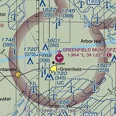
| Sectional chart |
|---|
|
| Airport distance calculator |
|---|
|
|
| Sunrise and sunset |
|---|
|
Times for 17-Apr-2026
| | Local
(UTC-5) | | Zulu
(UTC) |
|---|
| Morning civil twilight | | 06:07 | | 11:07 |
| Sunrise | | 06:36 | | 11:36 |
| Sunset | | 19:59 | | 00:59 |
| Evening civil twilight | | 20:28 | | 01:28 |
|
| Current date and time |
|---|
| Zulu (UTC) | 17-Apr-2026 12:18:46 |
|---|
| Local (UTC-5) | 17-Apr-2026 07:18:46 |
|---|
|
| METAR |
|---|
KCSQ
19nm S | 171155Z AUTO 17018G27KT 7SM BKN012 BKN018 BKN027 20/19 A2964 RMK AO2
|
KAIO
28nm W | 171155Z AUTO 17016G25KT 9SM OVC020 20/19 A2957 RMK AO2
|
KADU
31nm NW | 171155Z AUTO 18012G21KT 10SM 20/18 A2958 RMK AO2 PWINO
|
KPRO
33nm NE | 171155Z AUTO 17015KT 6SM BR CLR 18/18 A2959 RMK AO2 T01800176
|
KDSM
37nm E | 171154Z 14017KT 8SM BKN011 BKN250 19/17 A2965 RMK AO2 SLP034 T01890172 10189 20178 56021
|
KI75
38nm SE | 171155Z AUTO 16014G20KT 5SM BR BKN009 BKN075 19/18 A2968 RMK AO2 T01930175 10193 20168
|
|
| TAF |
|---|
KDSM
37nm E | 171139Z 1712/1812 17011KT P6SM SCT012 BKN250 WS020/18045KT TEMPO 1712/1713 BKN011 FM171300 17014G26KT P6SM FEW009 BKN022 FM171800 20017G31KT 4SM -TSRA BKN025CB FM172100 26019G31KT P6SM SCT027 PROB30 1721/1723 6SM -SHRA OVC027 FM172300 32021G28KT P6SM BKN090
|
|
| NOTAMs |
|---|
NOTAMs are issued by the DoD/FAA and will open in a separate window not controlled by AirNav.
|
|

