FAA INFORMATION EFFECTIVE 11 JUNE 2026
Location
| FAA Identifier: | 4M1 |
| Lat/Long: | 36-22-52.8310N 093-37-28.3450W
36-22.880517N 093-37.472417W
36.3813419,-93.6245403
(estimated) |
| Elevation: | 1205.6 ft. / 367.5 m (surveyed) |
| Variation: | 02E (2010) |
| From city: | 3 miles W of BERRYVILLE, AR |
| Time zone: | UTC -5 (UTC -6 during Standard Time) |
| Zip code: | 72616 |
Airport Operations
| Airport use: | Open to the public |
| Activation date: | 05/1966 |
| Control tower: | no |
| ARTCC: | MEMPHIS CENTER |
| FSS: | JONESBORO FLIGHT SERVICE STATION |
| NOTAMs facility: | JBR (NOTAM-D service available) |
| Attendance: | TUE-SAT 0800-1700 |
| Wind indicator: | lighted |
| Segmented circle: | yes |
| Lights: | ACTVT REIL RWY 07 & 25; PAPI RWY 07 & 25, MIRL RWY 07/25; TWY LGTS - CTAF. |
| Beacon: | white-green (lighted land airport)
Operates sunset to sunrise. |
Airport Communications
| CTAF: | 122.9 |
| RAZORBACK APPROACH: | 126.6 |
| RAZORBACK DEPARTURE: | 126.6 |
- APCH/DEP SVC PRVDD BY MEMPHIS ARTCC ON FREQS 126.1/269.0 (FAYETTEVILLE RCAG) WHEN RAZORBACK APCH CTL CLSD.
Nearby radio navigation aids
| VOR radial/distance | | VOR name | | Freq | | Var |
|---|
| HROr277/20.2 | | HARRISON VOR/DME | | 112.50 | | 04E |
| RZCr067/25.3 | | RAZORBACK VORTAC | | 116.40 | | 04E |
Airport Services
| Fuel available: | 100LL
100LL:FUEL AVBL 24 HR SELF SERVE WITH CREDIT CARD. |
| Parking: | hangars and tiedowns |
| Airframe service: | MAJOR |
| Powerplant service: | MAJOR |
| Bottled oxygen: | NONE |
| Bulk oxygen: | NONE |
Runway Information
Runway 7/25
| Dimensions: | 3555 x 75 ft. / 1084 x 23 m |
| Surface: | asphalt, in good condition |
| Weight bearing capacity: | |
| Runway edge lights: | medium intensity |
| RUNWAY 7 | | RUNWAY 25 |
| Latitude: | 36-22.796903N | | 36-22.964125N |
| Longitude: | 093-37.819583W | | 093-37.125227W |
| Elevation: | 1166.9 ft. | | 1205.1 ft. |
| Traffic pattern: | left | | left |
| Runway heading: | 071 magnetic, 073 true | | 251 magnetic, 253 true |
| Markings: | nonprecision, in good condition | | nonprecision, in good condition |
| Visual slope indicator: | 2-light PAPI on left (3.00 degrees glide path) | | 2-light PAPI on left (3.00 degrees glide path) |
| Runway end identifier lights: | yes | | yes |
| Touchdown point: | yes, no lights | | yes, no lights |
| Obstructions: | 30 ft. trees, 1250 ft. from runway, 175 ft. left of centerline, 35:1 slope to clear | | 17 ft. trees, 580 ft. from runway, 100 ft. left of centerline, 22:1 slope to clear |
Airport Ownership and Management from official FAA records
| Ownership: | Publicly-owned |
| Owner: | CARROLL COUNTY
210 WEST CHURCH ST.
BERRYVILLE, AR 72616
Phone 870-423-2967 |
| Manager: | DAVE TEIGEN
518 COUNTY ROAD 308
BERRYVILLE, AR 72616
Phone 870-423-8393 |
Additional Remarks
| - | NO LINE OF SIGHT BTN RY ENDS. |
| - | ULTRALIGHT ACTIVITY ON & INVOF ARPT. |
| - | DEER, TURKEY ON & INVOF ARPT. |
| - | FOR CD CTC RAZORBACK APCH 479-649-2416, WHEN APCH CLSD CTC MEMPHIS ARTCC AT 901-368-8453/8449. |
Instrument Procedures
NOTE: All procedures below are presented as PDF files. If you need a reader for these files, you should download the free Adobe Reader.NOT FOR NAVIGATION. Please procure official charts for flight.
FAA instrument procedures published for use from 11 June 2026 at 0901Z to 09 July 2026 at 0900z.
IAPs - Instrument Approach Procedures |
|---|
| RNAV (GPS) RWY 07 | |
download (235KB) |
| RNAV (GPS) RWY 25 | |
download (272KB) |
| NOTE: Special Take-Off Minimums/Departure Procedures apply | |
download (410KB) |
Other nearby airports with instrument procedures:
H34 - Huntsville Municipal Airport (19 nm S)
KFWB - Branson West Municipal Airport/Emerson Field (22 nm NE)
KBBG - Branson Airport (22 nm NE)
94K - Cassville Municipal Airport (23 nm NW)
KROG - Rogers Executive Airport - Carter Field (23 nm W)
|
|

Road maps at:
MapQuest
Bing
Google
| Aerial photo |
|---|
WARNING: Photo may not be current or correct
 Photo courtesy of the Arkansas Department of Aeronautics
Taken in the Spring of 2007
Photo courtesy of the Arkansas Department of Aeronautics
Taken in the Spring of 2007
Do you have a better or more recent aerial photo of Carroll County Airport that you would like to share? If so, please send us your photo.
|
| Sectional chart |
|---|
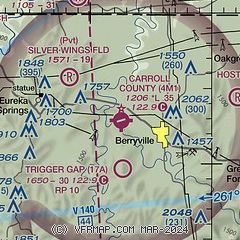
|
| Airport distance calculator |
|---|
|
|
| Sunrise and sunset |
|---|
|
Times for 17-Jun-2026
| | Local
(UTC-5) | | Zulu
(UTC) |
|---|
| Morning civil twilight | | 05:27 | | 10:27 |
| Sunrise | | 05:57 | | 10:57 |
| Sunset | | 20:33 | | 01:33 |
| Evening civil twilight | | 21:04 | | 02:04 |
|
| Current date and time |
|---|
| Zulu (UTC) | 17-Jun-2026 13:40:56 |
|---|
| Local (UTC-5) | 17-Jun-2026 08:40:56 |
|---|
|
| METAR |
|---|
KFWB
22nm NE | 171315Z AUTO 21008G13KT 170V240 8SM CLR 24/20 A2967 RMK AO2
|
KROG
22nm W | 171258Z 20019G24KT 10SM FEW002 24/20 RMK AO2 SLPNO T02440200 $
|
KBBG
22nm NE | 171245Z 17005KT 10SM CLR 23/20 A2971
|
KHRO
24nm E | 171253Z AUTO 17004KT 10SM CLR 24/19 A2971 RMK AO2 SLP045 T02390194
|
KASG
27nm SW | 171248Z 18013KT 10SM CLR 24/24 A2971
|
KVBT
29nm W | 171256Z AUTO 20010G18KT 10SM CLR 24/22 A2971 RMK AO2 SLP050 T02390217 $
|
KXNA
33nm W | 171253Z 19012G18KT 10SM FEW003 23/21 A2970 RMK AO2 SLP041 T02330206
|
KFYV
34nm SW | 171253Z 19012KT 9SM CLR 24/20 A2970 RMK AO2 SLP043 T02390200
|
KHFJ
37nm NW | 171315Z AUTO 20012G20KT 10SM CLR 23/20 A2966 RMK AO2
|
KSLG
42nm W | 171256Z AUTO 18015G20KT 10SM CLR 23/22 A2970 RMK AO2 SLP045 T02330217
|
|
| TAF |
|---|
KROG
22nm W | 171127Z 1712/1812 18011KT P6SM SCT250 FM171500 20019G28KT P6SM SCT040 FM180100 20010KT P6SM SCT250 FM181000 11004KT P6SM BKN015
|
KBBG
22nm NE | 171120Z 1712/1812 18008KT P6SM SCT100 FM171500 20015G25KT P6SM FEW250 FM180100 20008KT P6SM SCT050 BKN100 FM180800 VRB03KT P6SM BKN050 OVC100
|
KHRO
24nm E | 171126Z 1712/1812 VRB04KT P6SM SKC FM171500 19014G22KT P6SM SCT060 SCT250 FM180100 18008KT P6SM BKN250 FM180800 19003KT P6SM BKN100 FM181100 24005KT 5SM BR OVC025
|
|
| NOTAMs |
|---|
NOTAMs are issued by the DoD/FAA and will open in a separate window not controlled by AirNav.
|
|


