FAA INFORMATION EFFECTIVE 15 MAY 2025
Location
| FAA Identifier: | 50F |
| Lat/Long: | 32-34-54.6000N 097-35-26.8000W
32-34.910000N 097-35.446667W
32.5818333,-97.5907778
(estimated) |
| Elevation: | 873.2 ft. / 266.2 m (surveyed) |
| Variation: | 06E (2000) |
| From city: | 17 miles SW of FORT WORTH, TX |
| Time zone: | UTC -5 (UTC -6 during Standard Time) |
| Zip code: | 76126 |
Airport Operations
| Airport use: | Open to the public |
| Activation date: | 09/1981 |
| Control tower: | no |
| ARTCC: | FORT WORTH CENTER |
| FSS: | FORT WORTH FLIGHT SERVICE STATION |
| NOTAMs facility: | FTW (NOTAM-D service available) |
| Attendance: | MON-SAT DAYLIGHT HOURS
FOR SVCS AFT HRS CALL 817-752-4701. |
| Wind indicator: | lighted |
| Segmented circle: | yes |
| Lights: | ACTVT MIRL RWY 17/35 - CTAF. VASI RWYS 17 & 35 OPR CONSLY. |
| Beacon: | white-green (lighted land airport)
Operates sunset to sunrise. |
Airport Communications
| CTAF/UNICOM: | 123.0 |
| LONE STAR APPROACH: | 135.975 |
| LONE STAR DEPARTURE: | 135.975 |
| BOTCH DP: | 135.975 |
| DODJE STAR: | 125.2 125.9 |
| GARLAND DP: | 135.975 |
| LIKES STAR: | 125.8 ;SOUTH 135.975 ;NORTH |
| MOTZA STAR: | 118.1 ;SOUTH 125.8 ;NORTH |
| REEKO STAR: | 125.2 |
| SASIE STAR: | 124.3 |
| TRUUK RNAV STAR: | 124.3 |
| WESAT STAR: | 118.1 ;SOUTH 125.8 ;NORTH |
| WX AWOS-3PT at FWS (14 nm E): | 120.025 (817-426-4172) |
| WX AWOS-3T at GDJ (14 nm SW): | 118.925 (817-573-7514) |
| WX AWOS-3 at CPT (16 nm SE): | 119.525 (817-641-4135) |
| WX ASOS at FTW (18 nm NE): | PHONE 817-740-3346 |
Nearby radio navigation aids
| VOR radial/distance | | VOR name | | Freq | | Var |
|---|
| MQPr104/22.3 | | MILLSAP VORTAC | | 117.70 | | 09E |
| FUZr222/27.8 | | RANGER VORTAC | | 115.70 | | 06E |
| TTTr232/32.7 | | MAVERICK VOR/DME | | 113.10 | | 06E |
| CVEr236/39.3 | | COWBOY VOR/DME | | 116.20 | | 06E |
Airport Services
| Fuel available: | 100LL JET-A
100LL:FUEL SELF SERVE. |
| Parking: | hangars and tiedowns |
Runway Information
Runway 17/35
| Dimensions: | 4049 x 60 ft. / 1234 x 18 m |
| Surface: | asphalt, in good condition |
| Runway edge lights: | medium intensity |
| RUNWAY 17 | | RUNWAY 35 |
| Latitude: | 32-35.240523N | | 32-34.580380N |
| Longitude: | 097-35.505517W | | 097-35.388090W |
| Elevation: | 873.1 ft. | | 836.7 ft. |
| Traffic pattern: | left | | left |
| Runway heading: | 165 magnetic, 171 true | | 345 magnetic, 351 true |
| Displaced threshold: | 392 ft. | | 215 ft. |
| Markings: | nonprecision, in good condition | | nonprecision, in good condition |
| Visual slope indicator: | 2-box VASI on left (3.00 degrees glide path) | | 2-box VASI on left (3.50 degrees glide path) |
| Touchdown point: | yes, no lights | | yes, no lights |
| Obstructions: | 19 ft. road, 201 ft. from runway, 250 ft. left and right of centerline
19 FT RD 0-199 FT DSTC 125 FT L/R. | | 21 ft. trees, 201 ft. from runway, 68 ft. right of centerline
30 FT TREES, 0 FT DSTC, 100 FT R. |
Airport Ownership and Management from official FAA records
| Ownership: | Privately-owned |
| Owner: | BOURLAND FIELD ESTATES HOA INC
101 CONSETELLATION DR
CRESSON, TX 76035
Phone 817-396-4554
FBO PHONE. |
| Manager: | PATRICK HOYT
101 CONSTELLATION DR
CRESSON, TX 76035
Phone 817-752-4701
BOURLANDAIRPORT50F@GMAIL.COM ALT PHONE 951-283-4076 |
Additional Remarks
| - | FOR CD CTC REGIONAL APCH AT 972-615-2799. |
| - | DEER ON & INVOF RWY. |
| - | RWY HOLD SHORT LINES NSTD 25 FT FM RWY EDGE. |
| - | ARPT CLSD TO TSNT STUDENT TFC. |
| - | ARPT CLSD TO ACFT OVR 12500 LB MAX GWT. |
Instrument Procedures
NOTE: All procedures below are presented as PDF files. If you need a reader for these files, you should download the free Adobe Reader.NOT FOR NAVIGATION. Please procure official charts for flight.
FAA instrument procedures published for use from 15 May 2025 at 0901Z to 13 June 2025 at 0900z.
STARs - Standard Terminal Arrivals |
|---|
| LIKES THREE (RNAV) | |
download (204KB) |
| MOTZA ONE | |
2 pages:
[1] [2] (425KB) |
| REEKO THREE (RNAV) | |
download (214KB) |
| SASIE SEVEN | |
2 pages:
[1] [2] (442KB) |
| TRUUK TWO (RNAV) | |
download (219KB) |
| WESAT TWO (RNAV) | |
download (206KB) |
IAPs - Instrument Approach Procedures |
|---|
| RNAV (GPS) RWY 17 | |
download (170KB) |
| RNAV (GPS) RWY 35 | |
download (185KB) |
Departure Procedures |
|---|
| BOTCH ONE (RNAV) **NEW** | |
2 pages:
[1] [2] (354KB) |
| GARLAND SIX **NEW** | |
2 pages:
[1] [2] (329KB) |
| KINGDOM FIVE **NEW** | |
2 pages:
[1] [2] (351KB) |
| KUSSO ONE (RNAV) | |
2 pages:
[1] [2] (318KB) |
| NANDR THREE (RNAV) **NEW** | |
2 pages:
[1] [2] (301KB) |
| NOTE: Special Take-Off Minimums/Departure Procedures apply | |
download (308KB) |
Other nearby airports with instrument procedures:
KWEA - Parker County Airport (11 nm NW)
KNFW - Fort Worth Naval Air Station JRB (Carswell Field) Airport (14 nm NE)
KFWS - Fort Worth Spinks Airport (14 nm E)
KGDJ - Granbury Regional Airport (14 nm SW)
KCPT - Cleburne Regional Airport (16 nm SE)
KFTW - Fort Worth Meacham International Airport (18 nm NE)
|
|

Road maps at:
MapQuest
Bing
Google
| Aerial photo |
|---|
WARNING: Photo may not be current or correct
 Photo by Paul Bristow
Photo taken 01-Jun-2008
Photo by Paul Bristow
Photo taken 01-Jun-2008
Do you have a better or more recent aerial photo of Bourland Field Airport that you would like to share? If so, please send us your photo.
|
| Sectional chart |
|---|
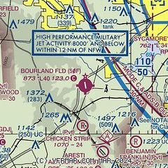
|
| Airport distance calculator |
|---|
|
|
| Sunrise and sunset |
|---|
|
Times for 21-May-2025
| | Local
(UTC-5) | | Zulu
(UTC) |
|---|
| Morning civil twilight | | 06:02 | | 11:02 |
| Sunrise | | 06:29 | | 11:29 |
| Sunset | | 20:25 | | 01:25 |
| Evening civil twilight | | 20:52 | | 01:52 |
|
| Current date and time |
|---|
| Zulu (UTC) | 21-May-2025 11:48:28 |
|---|
| Local (UTC-5) | 21-May-2025 06:48:28 |
|---|
|
| METAR |
|---|
KNFW
13nm NE | 211052Z 00000KT 10SM CLR 17/11 A2995 RMK AO2 SLP126 T01720111 $
|
KGDJ
14nm SW | AWOS-3 118.925 817-573-7514
211135Z AUTO 00000KT CLR 14/10 A2999 RMK AO2 T01400104 PWINO
|
KFWS
15nm E | 202345Z 01008KT 10SM CLR 27/09 A2990
|
KCPT
16nm SE | 211135Z AUTO 17008KT 8SM CLR 15/12 A2994 RMK AO2 T01490122 $
|
KFTW
19nm NE | 211053Z 00000KT 10SM CLR 17/11 A2994 RMK AO2 SLP130 T01670111
|
KGKY
25nm E | 211053Z AUTO 00000KT 10SM CLR 13/11 A2995 RMK AO2 SLP135 T01280111 $
|
|
| TAF |
|---|
KNFW
13nm NE | 2107/2207 20009KT 9999 SKC QNH2983INS FM211800 16012G18KT 9999 SKC QNH2985INS AUTOMATED SENSOR METWATCH 2107 TIL 2111 TX31/2122Z TN17/2112Z FN00287
|
KFTW
19nm NE | 210850Z 2109/2206 VRB04KT P6SM FEW250 FM211500 17013KT P6SM SCT250
|
|
| NOTAMs |
|---|
NOTAMs are issued by the DoD/FAA and will open in a separate window not controlled by AirNav.
|
|


