FAA INFORMATION EFFECTIVE 11 JUNE 2026
Location
| FAA Identifier: | 7B9 |
| Lat/Long: | 41-55-31.5000N 072-27-25.6000W
41-55.525000N 072-27.426667W
41.9254167,-72.4571111
(estimated) |
| Elevation: | 253 ft. / 77 m (estimated) |
| Variation: | 15W (1985) |
| From city: | 2 miles N of ELLINGTON, CT |
| Time zone: | UTC -4 (UTC -5 during Standard Time) |
| Zip code: | 06029 |
Airport Operations
| Airport use: | Open to the public |
| Activation date: | 04/1968 |
| Control tower: | no |
| ARTCC: | BOSTON CENTER |
| FSS: | BRIDGEPORT FLIGHT SERVICE STATION |
| NOTAMs facility: | BDR (NOTAM-D service available) |
| Attendance: | 0800-1800 |
| Wind indicator: | lighted |
| Segmented circle: | no |
| Lights: | NON-STD LIRL OPR DUSK-2400; FOR LGTS AFT 0000 CALL 860-871-2054 DURG BUS HRS. |
Airport Communications
| CTAF/UNICOM: | 123.0 |
| WX ASOS at BDL (10 nm W): | 118.15 (860-386-3480) |
| WX ASOS at HFD (14 nm SW): | PHONE 860-952-9954 |
| WX ASOS at IJD (16 nm SE): | 133.675 (860-456-8839) |
| WX ASOS at BAF (18 nm NW): | 127.1 (413-568-2267) |
Nearby radio navigation aids
| VOR radial/distance | | VOR name | | Freq | | Var |
|---|
| HFDr026/17.5 | | HARTFORD VOR/DME | | 114.90 | | 13W |
| BAFr155/18.3 | | BARNES VORTAC | | 113.00 | | 14W |
| PUTr280/27.4 | | PUTNAM VOR/DME | | 117.40 | | 14W |
| ORWr331/30.2 | | NORWICH VOR/DME | | 110.00 | | 14W |
| CTRr148/31.0 | | CHESTER VOR/DME | | 115.10 | | 13W |
| MADr029/38.2 | | MADISON VOR/DME | | 110.40 | | 13W |
Airport Services
| Fuel available: | 100LL |
| Parking: | hangars and tiedowns |
| Airframe service: | MAJOR |
| Powerplant service: | MAJOR |
Runway Information
Runway 1/19
| Dimensions: | 1800 x 50 ft. / 549 x 15 m |
| Surface: | asphalt, in fair condition |
| Weight bearing capacity: | |
| Runway edge lights: | non-standard
NON-STD LIRL DUE TO SPACING, THR LGTS OUTBOARD OF RWY. |
| Runway edge markings: | MKGS FADED. |
| RUNWAY 1 | | RUNWAY 19 |
| Latitude: | 41-55.377868N | | 41-55.673293N |
| Longitude: | 072-27.409568W | | 072-27.442492W |
| Traffic pattern: | left | | left |
| Runway heading: | 010 magnetic, 355 true | | 190 magnetic, 175 true |
| Markings: | numbers only, in poor condition | | numbers only, in poor condition |
| Obstructions: | 61 ft. trees, 384 ft. from runway, 125 ft. left of centerline, 3:1 slope to clear
6 FT SIGN, 66 FT DSTC, 103 FT L. | | 35 ft. trees, 401 ft. from runway, 90 ft. right of centerline, 5:1 slope to clear
25 FT TREES, 0-199 FT DSTC, 105 FT R. |
Airport Ownership and Management from official FAA records
| Ownership: | Privately-owned |
| Owner: | CONNECTICUT PARACHUTISTS INC
P. O. BOX 507
ELLINGTON, CT 06029
Phone 860-871-0021 |
| Manager: | BRIAN KNIGHT
3 WINGSTONE LN
DEVON, PA 19333-0021
Phone 860-614-1854
ADDL CTC ROBERT SMITH, 860-930-9235. |
Additional Remarks
| - | EXTSV HEL TRNG OPNS. |
| - | NON-STD THR LGTS. |
| - | FOR CD CTC BRADLEY APCH AT 860-386-3597. |
| - | ACFT TFC PAT ON E SIDE OF ARPT ONLY. HEL TFC PAT ON W SIDE OF ARPT ONLY. |
| - | TWY PAVEMENT FAILED, EXTSV CRACKING, PATCHES, LOOSE AGGREGATE AND SML STONES. |
Instrument Procedures
There are no published instrument procedures at 7B9.
Some nearby airports with instrument procedures:
KBDL - Bradley International Airport (10 nm W)
KHFD - Hartford-Brainard Airport (14 nm SW)
KIJD - Windham Airport (16 nm SE)
KCEF - Westover Air Reserve Base/Metropolitan Airport (16 nm N)
KBAF - Westfield-Barnes Regional Airport (18 nm NW)
|
|

Road maps at:
MapQuest
Bing
Google
| Aerial photo |
|---|
WARNING: Photo may not be current or correct
 Photo by David Gerstein
Photo taken 25-Nov-2017
looking north.
Photo by David Gerstein
Photo taken 25-Nov-2017
looking north.
Do you have a better or more recent aerial photo of Ellington Airport that you would like to share? If so, please send us your photo.
|
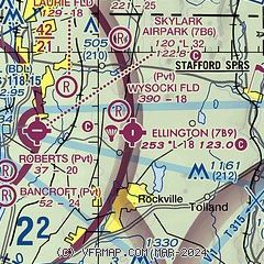
| Sectional chart |
|---|
|
| Airport distance calculator |
|---|
|
|
| Sunrise and sunset |
|---|
|
Times for 16-Jun-2026
| | Local
(UTC-4) | | Zulu
(UTC) |
|---|
| Morning civil twilight | | 04:40 | | 08:40 |
| Sunrise | | 05:15 | | 09:15 |
| Sunset | | 20:26 | | 00:26 |
| Evening civil twilight | | 21:00 | | 01:00 |
|
| Current date and time |
|---|
| Zulu (UTC) | 16-Jun-2026 12:33:51 |
|---|
| Local (UTC-4) | 16-Jun-2026 08:33:51 |
|---|
|
| METAR |
|---|
KBDL
10nm W | 161151Z 00000KT 10SM FEW250 16/08 A2986 RMK AO2 SLP110 T01560083 10156 20100 51009
|
KHFD
14nm SW | 161153Z 30004KT 10SM CLR 16/08 A2986 RMK AO2 SLP110 T01610078 10161 20117 51010
|
KIJD
16nm SE | 161152Z AUTO 35005KT 10SM CLR 16/09 A2985 RMK AO2 SLP106 T01560089 10156 20111 50010
|
KCEF
17nm N | 161155Z 32004KT 10SM FEW250 16/08 A2982 RMK AO2A SLP101 T01550078 10166 20088 52010
|
KBAF
19nm NW | 161153Z 00000KT 10SM CLR 16/08 A2985 RMK AO2 SLP107 T01610083 10161 20106 51008
|
|
| TAF |
|---|
KBDL
10nm W | 161128Z 1612/1718 30007KT P6SM FEW060 FM162200 26007KT P6SM FEW060 FEW210 FM170200 17004KT P6SM SCT200
|
KCEF
17nm N | 161200Z 1612/1718 VRB06KT 9999 SCT250 QNH2978INS BECMG 1618/1619 30012KT 9999 SCT060 BKN250 QNH2976INS BECMG 1700/1701 VRB06KT 9999 SCT250 QNH2979INS TX27/1620Z TN11/1710Z
|
KBAF
19nm NW | 160400Z 1604/1710 32010G15KT 9999 SKC QNH2975INS BECMG 1609/1610 31005KT 9999 FEW050 QNH2980INS BECMG 1613/1614 31010G15KT 9999 FEW050 QNH2975INS BECMG 1622/1623 VRB06KT 9999 FEW070 QNH2976INS TX24/1619Z TN13/1610Z
|
|
| NOTAMs |
|---|
NOTAMs are issued by the DoD/FAA and will open in a separate window not controlled by AirNav.
|
|

