FAA INFORMATION EFFECTIVE 19 MARCH 2026
Location
| FAA Identifier: | 8K2 |
| Lat/Long: | 37-16-41.4710N 098-02-36.5220W
37-16.691183N 098-02.608700W
37.2781864,-98.0434783
(estimated) |
| Elevation: | 1427 ft. / 434.9 m (surveyed) |
| Variation: | 07E (1985) |
| From city: | 1 mile SW of HARPER, KS |
| Time zone: | UTC -5 (UTC -6 during Standard Time) |
| Zip code: | 67058 |
Airport Operations
| Airport use: | Open to the public |
| Activation date: | 06/1947 |
| Control tower: | no |
| ARTCC: | KANSAS CITY CENTER |
| FSS: | WICHITA FLIGHT SERVICE STATION |
| NOTAMs facility: | ICT (NOTAM-D service available) |
| Attendance: | UNATNDD |
| Wind indicator: | lighted |
| Segmented circle: | no |
| Lights: | ACTVT PAPI RWY 17 & 35, HIRL RWY 17/35 - CTAF. |
Airport Communications
| CTAF: | 122.9 |
| WICHITA APPROACH: | 126.7 |
| WICHITA DEPARTURE: | 126.7 |
| WX AWOS-3PT at ANY (7 nm S): | 119.575 (620-842-4345) |
Nearby radio navigation aids
| VOR radial/distance | | VOR name | | Freq | | Var |
|---|
| ICTr211/35.6 | | WICHITA VORTAC | | 113.80 | | 07E |
Airport Services
| Fuel available: | 100LL
100LL:FUEL SELF SERVE. |
| Oil available: | AUTOMATED UNICOM; 3 CLICKS ADZY & WX, 4 CLICKS RADIO CHECK. ADZY ALSO AVBL BY CALLING 617-262-3825. |
| Parking: | tiedowns |
| Bottled oxygen: | NONE |
| Bulk oxygen: | NONE |
Runway Information
Runway 17/35
| Dimensions: | 3268 x 38 ft. / 996 x 12 m |
| Surface: | asphalt, in good condition |
| Runway edge lights: | high intensity |
| RUNWAY 17 | | RUNWAY 35 |
| Latitude: | 37-16.916133N | | 37-16.380100N |
| Longitude: | 098-02.615700W | | 098-02.551767W |
| Elevation: | 1427.0 ft. | | 1424.0 ft. |
| Traffic pattern: | left | | left |
| Runway heading: | 168 magnetic, 175 true | | 348 magnetic, 355 true |
| Markings: | basic, in good condition | | basic, in good condition |
| Visual slope indicator: | 2-light PAPI on left (3.25 degrees glide path)
RWY 17 PAPI UNUSBL BYD 3 DEGS L OF CNTRLN. | | 2-light PAPI on left (3.25 degrees glide path) |
| Touchdown point: | yes, no lights | | yes, no lights |
| Obstructions: | 44 ft. tree, 440 ft. from runway, 156 ft. left of centerline, 5:1 slope to clear | | none |
Runway 12/30
| Dimensions: | 2138 x 160 ft. / 652 x 49 m |
| Surface: | turf, in good condition |
| Runway edge markings: | MKD WITH METAL ORANGE CONES. |
| RUNWAY 12 | | RUNWAY 30 |
| Latitude: | 37-16.878750N | | 37-16.634617N |
| Longitude: | 098-02.806417W | | 098-02.488600W |
| Elevation: | 1426.0 ft. | | 1426.0 ft. |
| Traffic pattern: | left | | left |
| Runway heading: | 127 magnetic, 134 true | | 307 magnetic, 314 true |
| Markings: | , in good condition | | |
| Obstructions: | 49 ft. pline, 644 ft. from runway, 207 ft. left and right of centerline, 13:1 slope to clear | | 42 ft. pline, 788 ft. from runway, 205 ft. left and right of centerline, 18:1 slope to clear |
Airport Ownership and Management from official FAA records
| Ownership: | Publicly-owned |
| Owner: | CITY OF HARPER
201 W. MAIN
HARPER, KS 67058
Phone 620-896-2511 |
| Manager: | KAREN BEFORT
201 WEST MAIN
HARPER, KS 67058
Phone 620-896-2511
DEPUTY CITY CLERK/AMGR. |
Additional Remarks
| - | RWY 12, 3 FT DITCH 50 FM N END. |
| - | FOR CD CTC WICHITA APCH AT 316-350-1520. |
Instrument Procedures
NOTE: All procedures below are presented as PDF files. If you need a reader for these files, you should download the free Adobe Reader.NOT FOR NAVIGATION. Please procure official charts for flight.
FAA instrument procedures published for use from 19 March 2026 at 0901Z to 16 April 2026 at 0900Z.
IAPs - Instrument Approach Procedures |
|---|
| RNAV (GPS)-A | |
download (189KB) |
| NOTE: Special Take-Off Minimums/Departure Procedures apply | |
download (352KB) |
Other nearby airports with instrument procedures:
KANY - Anthony Municipal Airport (7 nm S)
9K8 - Kingman Airport/Clyde Cessna Field (24 nm N)
KEGT - Wellington Municipal Airport (31 nm E)
O53 - Medford Municipal Airport (32 nm SE)
KICT - Wichita Dwight D Eisenhower National Airport (37 nm NE)
|
|

Road maps at:
MapQuest
Bing
Google
| Aerial photo |
|---|
WARNING: Photo may not be current or correct
 Photo by Von Rothenberger
Photo taken 03-Sep-2010
looking north.
Photo by Von Rothenberger
Photo taken 03-Sep-2010
looking north.
Do you have a better or more recent aerial photo of Harper Municipal Airport that you would like to share? If so, please send us your photo.
|
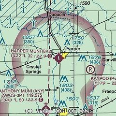
| Sectional chart |
|---|
|
| Airport distance calculator |
|---|
|
|
| Sunrise and sunset |
|---|
|
Times for 02-Apr-2026
| | Local
(UTC-5) | | Zulu
(UTC) |
|---|
| Morning civil twilight | | 06:51 | | 11:51 |
| Sunrise | | 07:17 | | 12:17 |
| Sunset | | 19:54 | | 00:54 |
| Evening civil twilight | | 20:21 | | 01:21 |
|
| Current date and time |
|---|
| Zulu (UTC) | 02-Apr-2026 09:32:28 |
|---|
| Local (UTC-5) | 02-Apr-2026 04:32:28 |
|---|
|
| METAR |
|---|
KANY
7nm S | 020915Z AUTO 18016G21KT 10SM OVC013 18/18 A2952 RMK AO2
|
|
| TAF |
|---|
KICT
37nm NE | 020721Z 0207/0306 15008KT P6SM VCSH BKN020 FM021300 22017G26KT P6SM BKN035 FM021800 27013KT P6SM FEW250 FM030000 18008KT P6SM FEW250
|
KIAB
42nm NE | 020800Z 0208/0308 17015G22KT 9999 OVC060 QNH2950INS TEMPO 0208/0209 8000 -SHRA VCTS OVC050CB BECMG 0208/0209 18015G25KT 9999 OVC008 WS020/20040KT QNH2950INS BECMG 0214/0215 25012G22KT 9999 SCT050 QNH2967INS BECMG 0300/0301 18006KT 9999 SKC QNH2972INS TX23/0222Z TN15/0212Z
|
|
| NOTAMs |
|---|
NOTAMs are issued by the DoD/FAA and will open in a separate window not controlled by AirNav.
|
|

