FAA INFORMATION EFFECTIVE 15 MAY 2025
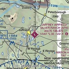
Location
| FAA Identifier: | AFN |
| Lat/Long: | 42-48-18.4830N 072-00-10.8790W
42-48.308050N 072-00.181317W
42.8051342,-72.0030219
(estimated) |
| Elevation: | 1039.5 ft. / 317 m (estimated) |
| Variation: | 14W (1970) |
| From city: | 1 mile SE of JAFFREY, NH |
| Time zone: | UTC -4 (UTC -5 during Standard Time) |
| Zip code: | 03452 |
Airport Operations
| Airport use: | Open to the public |
| Activation date: | 02/1947 |
| Control tower: | no |
| ARTCC: | BOSTON CENTER |
| FSS: | BANGOR FLIGHT SERVICE STATION |
| NOTAMs facility: | AFN (NOTAM-D service available) |
| Attendance: | 0800-DUSK |
| Wind indicator: | yes |
| Segmented circle: | no |
| Lights: | PPR FOR NSTD LIRL CALL 603-532-8870. |
Airport Communications
| CTAF/UNICOM: | 122.8 |
| WX ASOS: | 135.875 (603-532-6195) |
| WX AWOS-3PT at EEN (13 nm NW): | 119.025 (603-358-6424) |
| WX ASOS at FIT (19 nm SE): | 135.175 (978-343-9121) |
| WX ASOS at ORE (19 nm SW): | 135.675 (978-544-6774) |
- APCH/DEP SVC PRVDD BY BOSTON ARTCC ON FREQS 123.75/338.2 (GARDNER RCAG).
Nearby radio navigation aids
| VOR radial/distance | | VOR name | | Freq | | Var |
|---|
| GDMr023/15.7 | | GARDNER VOR/DME | | 116.95 | | 14W |
| CONr232/31.2 | | CONCORD VOR/DME | | 112.90 | | 15W |
| NDB name | | Hdg/Dist | | Freq | | Var | | ID |
|---|
| CLAREMONT | | 171/37.5 | | 233 | | 16W | | CNH | -.-. -. .... |
Airport Services
| Fuel available: | 100LL |
| Parking: | hangars and tiedowns |
| Airframe service: | MINOR |
| Powerplant service: | MINOR |
| Bottled oxygen: | NONE |
| Bulk oxygen: | NONE |
Runway Information
Runway 16/34
| Dimensions: | 2982 x 134 ft. / 909 x 41 m |
| Surface: | asphalt/turf, in excellent condition
50 FT CNTR PTN OF ENTR RWY IS ASPH, RMNG 42 FT PER SIDE IS TURF/GRVL FOR ENTR RWY LEN. |
| Weight bearing capacity: | |
| Runway edge lights: | low intensity
FIRST 582 FT RWY 34 NOT LGTD. |
| Runway edge markings: | NSTD CNTRLN & DTHR. |
| Operational restrictions: | TGLS PROHIBITED. |
| RUNWAY 16 | | RUNWAY 34 |
| Latitude: | 42-48.516333N | | 42-48.099867N |
| Longitude: | 072-00.357783W | | 072-00.004917W |
| Elevation: | 1039.5 ft. | | 1013.2 ft. |
| Traffic pattern: | left | | left |
| Runway heading: | 162 magnetic, 148 true | | 342 magnetic, 328 true |
| Displaced threshold: | no | | 582 ft. |
| Markings: | basic, in good condition | | basic, in good condition |
| Runway end identifier lights: | no | | no |
| Touchdown point: | yes, no lights | | yes, no lights |
| Obstructions: | 41 ft. trees, 409 ft. from runway, 133 ft. right of centerline, 5:1 slope to clear | | 67 ft. trees, 401 ft. from runway, 107 ft. right of centerline, 3:1 slope to clear
+6 FT TRRN/TREES 50 FT FM THR RISING TO +45 FT 200 FT FM THR. |
Airport Ownership and Management from official FAA records
| Ownership: | Privately-owned |
| Owner: | JAFFREY MUNI ARPT DEV CORP
190 TURNPIKE RD, JAFFREY AIRFIELD
JAFFREY, NH 03452 |
| Manager: | HARVEY N SAWYER
190 TURNPIKE RD, JAFFERY AIRFIELD
JAFFREY, NH 03452
Phone 603-532-8870 |
Additional Remarks
| - | ULTRALIGHT ACT ON ARPT. |
| - | PARL TWY SERVES HNGR/RAMP ONLY - NO ACES TO RWY 34. |
| - | WILDLIFE ON & INVOF ARPT. |
| - | FOR CD CTC BOSTON ARTCC AT 603-879-6859. |
| - | CALM WIND RWY IS RWY 34. |
Instrument Procedures
NOTE: All procedures below are presented as PDF files. If you need a reader for these files, you should download the free Adobe Reader.NOT FOR NAVIGATION. Please procure official charts for flight.
FAA instrument procedures published for use from 15 May 2025 at 0901Z to 13 June 2025 at 0900z.
IAPs - Instrument Approach Procedures |
|---|
| RNAV (GPS)-B **CHANGED** | |
download (187KB) |
| RNAV (GPS)-C **CHANGED** | |
download (181KB) |
| VOR-A **CHANGED** | |
download (220KB) |
| NOTE: Special Alternate Minimums apply | |
download (152KB) |
| NOTE: Special Take-Off Minimums/Departure Procedures apply | |
download (514KB) |
Other nearby airports with instrument procedures:
KEEN - Dillant/Hopkins Airport (13 nm NW)
KGDM - Gardner Municipal Airport (15 nm S)
KFIT - Fitchburg Municipal Airport (19 nm SE)
KORE - Orange Municipal Airport (19 nm SW)
KASH - Boire Field Airport (22 nm E)
|
|

Road maps at:
MapQuest
Bing
Google
| Aerial photo |
|---|
WARNING: Photo may not be current or correct
 Photo by Harvey N. Sawyer
Photo taken 15-Jun-2022
looking down runway 34.
Photo by Harvey N. Sawyer
Photo taken 15-Jun-2022
looking down runway 34.
Do you have a better or more recent aerial photo of Jaffrey Airfield Silver Ranch that you would like to share? If so, please send us your photo.
|
| Sectional chart |
|---|
|
| Airport distance calculator |
|---|
|
|
| Sunrise and sunset |
|---|
|
Times for 19-May-2025
| | Local
(UTC-4) | | Zulu
(UTC) |
|---|
| Morning civil twilight | | 04:49 | | 08:49 |
| Sunrise | | 05:22 | | 09:22 |
| Sunset | | 20:07 | | 00:07 |
| Evening civil twilight | | 20:40 | | 00:40 |
|
| Current date and time |
|---|
| Zulu (UTC) | 20-May-2025 01:41:02 |
|---|
| Local (UTC-4) | 19-May-2025 21:41:02 |
|---|
|
| METAR |
|---|
| KAFN | 200052Z AUTO 33007KT 280V040 10SM OVC029 08/03 A2982 RMK AO2 SLP105 T00830028
|
KORE
19nm SW | 200052Z AUTO 32015G22KT 10SM -RA OVC034 09/03 A2985 RMK AO2 SLP109 P0000 T00890033
|
KFIT
19nm SE | 200052Z AUTO 33011G21KT 10SM BKN041 OVC070 10/03 A2982 RMK AO2 SLP098 T01000028
|
|
| TAF |
|---|
KMHT
26nm E | 192004Z 1920/2018 32015G29KT P6SM VCSH SCT025 BKN035 BKN100 FM200400 33010G20KT P6SM SCT025 BKN035 TEMPO 2014/2017 BKN025
|
KCON
32nm NE | 191731Z 1918/2018 32017G30KT P6SM SCT028 BKN035 BKN080 FM192000 32015G26KT P6SM VCSH SCT025 BKN035 BKN100 FM200400 33010G20KT P6SM SCT025 BKN035 TEMPO 2014/2017 BKN025
|
|
| NOTAMs |
|---|
NOTAMs are issued by the DoD/FAA and will open in a separate window not controlled by AirNav.
|
|


