FAA INFORMATION EFFECTIVE 20 MARCH 2025
Location
| FAA Identifier: | BIL |
| Lat/Long: | 45-48-28.2569N 108-32-36.7568W
45-48.470948N 108-32.612613W
45.8078491,-108.5435436
(estimated) |
| Elevation: | 3662.3 ft. / 1116.3 m (surveyed) |
| Variation: | 10E (2020) |
| From city: | 2 miles NW of BILLINGS, MT |
| Time zone: | UTC -6 (UTC -7 during Standard Time) |
| Zip code: | 59105 |
Airport Operations
| Airport use: | Open to the public |
| Activation date: | 04/1940 |
| Control tower: | yes |
| ARTCC: | SALT LAKE CITY CENTER |
| FSS: | GREAT FALLS FLIGHT SERVICE STATION |
| NOTAMs facility: | BIL (NOTAM-D service available) |
| Attendance: | CONTINUOUS |
| Pattern altitude: | SINGLE ENGINE ACFT 4500 (838), MULTI ENGINE/TURBOJET ACFT 5000 (1338). |
| Wind indicator: | lighted |
| Segmented circle: | yes |
| Lights: | ATC-CTL. FOR MIRL RYS 10R/28L & 07/25; HIRL RY 10L/28R; MALSR RY 10L & REIL RYS 25 & 28R - CTC ATCT. |
| Beacon: | white-green (lighted land airport)
Operates sunset to sunrise. |
| Fire and rescue: | ARFF index C |
| Airline operations: | PPR UNSKED ACR OPNS WITH MORE THAN 30 PSGR SEATS CTC ARPT OPS 406-657-8496. ARFF INDEX B 0200-0500. |
Airport Communications
| UNICOM: | 122.95 |
| ATIS: | 126.3 |
| WX ASOS: | 126.3 (406-255-2790) |
| BILLINGS GROUND: | 121.9 |
| BILLINGS TOWER: | 127.2 257.8 |
| BILLINGS APPROACH: | 119.2 ;EAST 120.5 ;WEST 284.6 |
| BILLINGS DEPARTURE: | 119.2 ;EAST 120.5 ;WEST 284.6 |
| CLEARANCE DELIVERY: | 121.9 |
| PRE-TAXI CLEARANCE: | 121.9 |
| CLASS C: | 119.2 ;EAST 120.5 ;WEST 284.6 |
| EMERG: | 121.5 243.0 |
| IC: | 120.5 ;WEST |
| WX AWOS-2 at 6S8 (11 nm SW): | 135.05 (406-628-9867) |
Nearby radio navigation aids
| VOR radial/distance | | VOR name | | Freq | | Var |
|---|
| BILr077/3.4 | | BILLINGS VORTAC | | 114.50 | | 14E |
Airport Services
| Fuel available: | 100LL JET-A |
| Parking: | hangars and tiedowns |
| Airframe service: | MAJOR |
| Powerplant service: | MAJOR |
| Bottled oxygen: | HIGH/LOW |
| Bulk oxygen: | HIGH/LOW |
Runway Information
Runway 10L/28R
| Dimensions: | 10518 x 150 ft. / 3206 x 46 m |
| Surface: | asphalt/grooved, in good condition |
| Weight bearing capacity: | | Single wheel: | 120.0 | | Double wheel: | 214.0 | | Double tandem: | 365.0 |
|
| Runway edge lights: | high intensity |
| RUNWAY 10L | | RUNWAY 28R |
| Latitude: | 45-48.763500N | | 45-48.123167N |
| Longitude: | 108-33.289000W | | 108-30.990667W |
| Elevation: | 3584.4 ft. | | 3488.2 ft. |
| Traffic pattern: | left | | left |
| Runway heading: | 101 magnetic, 111 true | | 281 magnetic, 291 true |
| Declared distances: | TORA:10518 TODA:10518 ASDA:10518 LDA:10518 | | TORA:10518 TODA:10518 ASDA:10518 LDA:10518 |
| Markings: | precision, in good condition | | precision, in good condition |
| Visual slope indicator: | 4-light PAPI on left (3.00 degrees glide path) | | 4-light PAPI on right (3.00 degrees glide path) |
| RVR equipment: | touchdown | | rollout |
| Approach lights: | MALSR: 1,400 foot medium intensity approach lighting system with runway alignment indicator lights | | |
| Runway end identifier lights: | | | yes |
| Touchdown point: | yes, no lights | | yes, no lights |
| Instrument approach: | ILS/DME | | ILS/DME |
| Obstructions: | none | | 12 ft. gnd, 200 ft. from runway, 400 ft. left of centerline, 34:1 slope to clear
+12' GND 0-200' FM RY END 400' L. |
Runway 7/25
| Dimensions: | 5501 x 75 ft. / 1677 x 23 m |
| Surface: | asphalt/grooved, in good condition |
| Weight bearing capacity: | |
| Runway edge lights: | medium intensity |
| RUNWAY 7 | | RUNWAY 25 |
| Latitude: | 45-48.460500N | | 45-48.555322N |
| Longitude: | 108-33.503833W | | 108-32.217000W |
| Elevation: | 3636.3 ft. | | 3533.8 ft. |
| Traffic pattern: | left | | left |
| Runway heading: | 074 magnetic, 084 true | | 254 magnetic, 264 true |
| Declared distances: | TORA:5501 TODA:5501 ASDA:5501 LDA:5501 | | TORA:5501 TODA:5501 ASDA:5501 LDA:5501 |
| Markings: | nonprecision, in good condition | | nonprecision, in good condition |
| Visual slope indicator: | 4-light PAPI on left (3.00 degrees glide path) | | 4-light PAPI on right (3.00 degrees glide path) |
| Runway end identifier lights: | | | yes |
| Touchdown point: | yes, no lights | | yes, no lights |
| Obstructions: | 20 ft. gnd, 600 ft. from runway, 20:1 slope to clear | | none |
Runway 10R/28L
| Dimensions: | 3800 x 75 ft. / 1158 x 23 m |
| Surface: | asphalt, in good condition |
| Weight bearing capacity: | |
| Runway edge lights: | medium intensity |
| RUNWAY 10R | | RUNWAY 28L |
| Latitude: | 45-48.609280N | | 45-48.378475N |
| Longitude: | 108-33.977857W | | 108-33.147120W |
| Elevation: | 3662.3 ft. | | 3614.0 ft. |
| Traffic pattern: | left | | left |
| Runway heading: | 101 magnetic, 111 true | | 281 magnetic, 291 true |
| Declared distances: | TORA:3801 TODA:3801 ASDA:3801 LDA:3801 | | TORA:3801 TODA:3801 ASDA:3801 LDA:3801 |
| Markings: | basic, in fair condition | | basic, in fair condition |
| Touchdown point: | yes, no lights | | yes, no lights |
| Obstructions: | 52 ft. gnd, 2251 ft. from runway, 20:1 slope to clear | | none |
Airport Ownership and Management from official FAA records
| Ownership: | Publicly-owned |
| Owner: | CITY OF BILLINGS
CITY HALL
BILLINGS, MT 59101
Phone 406-657-8495 |
| Manager: | JEFF ROACH, MANAGER
1901 TERMINAL CIRCLE DR., ROOM 216
BILLINGS, MT 59105
Phone (406) 657-8484
406-657-8495 |
Additional Remarks
| A39-10L/28R | PCR VALUE: 745/F/B/X/T |
| A39-07/25 | PCR VALUE: 303/F/B/X/T |
| A39-10R/28L | PCR VALUE: 107/F/B/X/T |
| - | TWY D 35 FT WIDE CLSD TO ACFT OVER 12,500 LBS. |
| - | NO CUSTOMS, REMOTE ACFT PARKING, LTD GROUND HANDLING SVCS |
| - | 180 DEG TURNS PROHIBITED ON ALL SFCS. |
| - | MIGRATORY WATERFOWL INVOF ARPT. |
| - | RYS 07/25 AND 10R/28L CLSD TO ACFT OVER 12,500 LBS. |
Instrument Procedures
NOTE: All procedures below are presented as PDF files. If you need a reader for these files, you should download the free Adobe Reader.NOT FOR NAVIGATION. Please procure official charts for flight.
FAA instrument procedures published for use from 20 March 2025 at 0901Z to 17 April 2025 at 0900z.
STARs - Standard Terminal Arrivals |
|---|
| BGHRN THREE (RNAV) | |
download (200KB) |
| CRAZI FOUR (RNAV) | |
download (172KB) |
| KUSTR THREE (RNAV) | |
download (179KB) |
| YLSTN THREE (RNAV) | |
download (162KB) |
IAPs - Instrument Approach Procedures |
|---|
| HI-ILS Z OR LOC Z RWY 10L | |
download (123KB) |
| ILS OR LOC RWY 28R **CHANGED** | |
download (272KB) |
| ILS Y OR LOC Y RWY 10L **CHANGED** | |
download (270KB) |
| RNAV (RNP) Z RWY 28R **CHANGED** | |
download (224KB) |
| RNAV (GPS) RWY 07 **CHANGED** | |
download (255KB) |
| RNAV (GPS) RWY 10L **CHANGED** | |
download (240KB) |
| RNAV (GPS) RWY 25 **CHANGED** | |
download (237KB) |
| RNAV (GPS) Y RWY 28R **CHANGED** | |
download (238KB) |
| VOR/DME RWY 28R **CHANGED** | |
download (236KB) |
| HI-VOR OR TACAN RWY 28R | |
download (116KB) |
| NOTE: Special Alternate Minimums apply | |
download (184KB) |
Departure Procedures |
|---|
| BILLINGS FIVE | |
download (235KB) |
| NOTE: Special Take-Off Minimums/Departure Procedures apply | |
download (376KB) |
Other nearby airports with instrument procedures:
6S8 - Laurel Municipal Airport (11 nm SW)
00U - Big Horn County Airport (37 nm E)
KRPX - Roundup Airport (40 nm N)
U68 - North Big Horn County Airport (54 nm S)
KPOY - Powell Municipal Airport (57 nm S)
|
|

Road maps at:
MapQuest
Bing
Google
| Aerial photo |
|---|
WARNING: Photo may not be current or correct
 Photo by Don Larson
Photo taken 21-Feb-2016
looking northeast.
Photo by Don Larson
Photo taken 21-Feb-2016
looking northeast.
Do you have a better or more recent aerial photo of Billings Logan International Airport that you would like to share? If so, please send us your photo.
|
| Sectional chart |
|---|
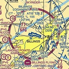
|
CAUTION: Diagram may not be current
 Download PDF
of official airport diagram from the FAA
| Airport distance calculator |
|---|
|
|
| Sunrise and sunset |
|---|
|
Times for 16-Apr-2025
| | Local
(UTC-6) | | Zulu
(UTC) |
|---|
| Morning civil twilight | | 05:56 | | 11:56 |
| Sunrise | | 06:27 | | 12:27 |
| Sunset | | 20:01 | | 02:01 |
| Evening civil twilight | | 20:32 | | 02:32 |
|
| Current date and time |
|---|
| Zulu (UTC) | 16-Apr-2025 09:39:37 |
|---|
| Local (UTC-6) | 16-Apr-2025 03:39:37 |
|---|
|
| METAR |
|---|
| KBIL | 160853Z 23013KT 10SM BKN180 11/M04 A2978 RMK AO2 SLP064 T01061039 50002
|
|
| TAF |
|---|
| KBIL | 160526Z 1606/1706 23008KT P6SM BKN220 FM160900 27010KT P6SM BKN200 FM161800 03011KT P6SM FEW060 BKN100 FM162200 04016G23KT 6SM -SHRA FEW015 BKN025 FM170500 02015G22KT 2SM RASN BR OVC008
|
|
| NOTAMs |
|---|
NOTAMs are issued by the DoD/FAA and will open in a separate window not controlled by AirNav.
|
|


