FAA INFORMATION EFFECTIVE 30 OCTOBER 2025
Location
| FAA Identifier: | C81 |
| Lat/Long: | 42-19-28.6000N 088-04-26.7170W
42-19.476667N 088-04.445283W
42.3246111,-88.0740881
(estimated) |
| Elevation: | 788 ft. / 240.2 m (surveyed) |
| Variation: | 02W (1995) |
| From city: | 2 miles SW of GRAYSLAKE, IL |
| Time zone: | UTC -6 (UTC -5 during Daylight Saving Time) |
| Zip code: | 60030 |
Airport Operations
| Airport use: | Open to the public |
| Activation date: | 02/1964 |
| Control tower: | no |
| ARTCC: | CHICAGO CENTER |
| FSS: | KANKAKEE FLIGHT SERVICE STATION |
| NOTAMs facility: | IKK (NOTAM-D service available) |
| Attendance: | MON-FRI 0830-1600, ALL SAT-SUN UNATTENDED |
| Pattern altitude: | 1588 ft. MSL |
| Wind indicator: | lighted |
| Segmented circle: | no |
| Lights: | SS-SR |
| Beacon: | white-green (lighted land airport)
Operates sunset to sunrise. |
Airport Communications
| CTAF/UNICOM: | 122.7 |
| CHICAGO APPROACH: | 120.55 |
| CHICAGO DEPARTURE: | 120.55 |
| WX ASOS at UGN (11 nm NE): | PHONE 847-782-0876 |
| WX ASOS at PWK (15 nm SE): | PHONE 847-465-0291 |
| WX ASOS at ENW (18 nm N): | PHONE 262-652-7730 |
Nearby radio navigation aids
| VOR radial/distance | | VOR name | | Freq | | Var |
|---|
| OBKr321/8.2 | | NORTHBROOK VOR/DME | | 113.00 | | 02W |
| DPAr023/28.8 | | DUPAGE VOR/DME | | 114.55 | | 02E |
| NDB name | | Hdg/Dist | | Freq | | Var | | ID |
|---|
| WAUKE | | 238/14.7 | | 379 | | 03W | | UG | ..- --. |
Airport Services
| Fuel available: | 100LL |
| Parking: | tiedowns |
| Airframe service: | MAJOR |
| Powerplant service: | MAJOR |
| Bottled oxygen: | NONE |
| Bulk oxygen: | NONE |
Runway Information
Runway 6/24
| Dimensions: | 3573 x 40 ft. / 1089 x 12 m
SW 1000 FT TURF-GRVL. |
| Surface: | asphalt/turf, in fair condition
PAVEMENT HAS SEVERAL AREAS OF DEPRESSIONS. RWY EDGES DROP OFF IN EXCESS OF 2 INCHES. |
| RUNWAY 6 | | RUNWAY 24 |
| Latitude: | 42-19.355167N | | 42-19.664050N |
| Longitude: | 088-04.784833W | | 088-04.110083W |
| Elevation: | 779.0 ft. | | 778.0 ft. |
| Traffic pattern: | left | | left |
| Runway heading: | 060 magnetic, 058 true | | 240 magnetic, 238 true |
| Displaced threshold: | no | | 301 ft.
RWY 24 NSTD DSPLCD THLD WHITE STRIPE MKGS ONLY. MARKED FOR RY 06 ON SW BEGINNING OF PAVED SURFACE. |
| Markings: | numbers only, in good condition | | numbers only, in good condition |
| Runway end identifier lights: | no | | no |
| Touchdown point: | yes, no lights | | yes, no lights |
| Obstructions: | 16 ft. trees, 253 ft. from runway, 90 ft. right of centerline, 15:1 slope to clear | | 78 ft. tree, 1540 ft. from runway, 86 ft. left of centerline, 17:1 slope to clear
+15 FT RD ADJ RWY END L & R. |
Runway 9/27
| Dimensions: | 3270 x 40 ft. / 997 x 12 m |
| Surface: | asphalt, in fair condition |
| Runway edge lights: | non-standard
LIRL SPACING & LGT INTST VARIES. |
| Operational restrictions: | RWY 09 & 27 NSTD TRIL OTS INDEFLY. |
| RUNWAY 9 | | RUNWAY 27 |
| Latitude: | 42-19.442133N | | 42-19.440650N |
| Longitude: | 088-04.803517W | | 088-04.078117W |
| Elevation: | 777.0 ft. | | 788.0 ft. |
| Traffic pattern: | left | | left |
| Runway heading: | 092 magnetic, 090 true | | 272 magnetic, 270 true |
| Markings: | numbers only, in good condition | | numbers only, in good condition |
| Visual slope indicator: | tri-color VASI on left (4.00 degrees glide path)
NSTD TRIL OPR DUSK-DAWN. | | tri-color VASI on left (4.00 degrees glide path)
NSTD TRIL OPR DUSK-DAWN. |
| Runway end identifier lights: | no | | no |
| Touchdown point: | yes, no lights | | yes, no lights |
Airport Ownership and Management from official FAA records
| Ownership: | Privately-owned |
| Owner: | KANE ILL PROPERTIES
PO BOX 474, SUITE 401
GRAYSLAKE, IL 60030
Phone 847-201-1618 |
| Manager: | CATHY KANE
PO BOX 474, 22731 W. TOWNLINE RD
GRAYSLAKE, IL 60030
Phone (847) 201-1618
EMAIL ADDRESS: PJK201@AOL.COM (ALL LOWER CASE) |
Additional Remarks
| - | NO TOUCH & GO LNDG PERMITTED. |
| - | UNLGTD POWER LINES 167 FT AGL 3/4 MILE S OF RWY 09/27. |
| - | NUMEROUS MIGRATORY BIRDS INVOF ARPT. |
| - | TWYS WITH NSTD SPACING AND CLEARANCES INVOF RAMP APRON. |
| - | FOR CD CTC CHICAGO APCH AT 847-289-0926. |
Instrument Procedures
NOTE: All procedures below are presented as PDF files. If you need a reader for these files, you should download the free Adobe Reader.NOT FOR NAVIGATION. Please procure official charts for flight.
FAA instrument procedures published for use from 30 October 2025 at 0901Z to 27 November 2025 at 0900Z.
IAPs - Instrument Approach Procedures |
|---|
| RNAV (GPS)-B | |
download (172KB) |
| NOTE: Special Take-Off Minimums/Departure Procedures apply | |
download (201KB) |
Other nearby airports with instrument procedures:
KUGN - Waukegan National Airport (11 nm NE)
3CK - Lake in the Hills Airport (13 nm SW)
10C - Galt Field Airport (14 nm W)
KPWK - Chicago Executive Airport (15 nm SE)
KENW - Kenosha Regional Airport (18 nm N)
|
|

Road maps at:
MapQuest
Bing
Google
| Aerial photo |
|---|
WARNING: Photo may not be current or correct
 Photo taken 05-Jul-2009
Do you have a better or more recent aerial photo of Campbell Airport that you would like to share? If so, please send us your photo.
|
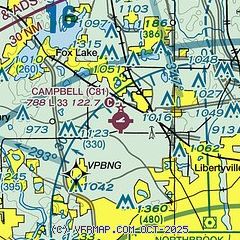
| Sectional chart |
|---|
|
| Airport distance calculator |
|---|
|
|
| Sunrise and sunset |
|---|
|
Times for 06-Nov-2025
| | Local
(UTC-6) | | Zulu
(UTC) |
|---|
| Morning civil twilight | | 06:03 | | 12:03 |
| Sunrise | | 06:33 | | 12:33 |
| Sunset | | 16:39 | | 22:39 |
| Evening civil twilight | | 17:09 | | 23:09 |
|
| Current date and time |
|---|
| Zulu (UTC) | 06-Nov-2025 13:02:52 |
|---|
| Local (UTC-6) | 06-Nov-2025 07:02:52 |
|---|
|
| METAR |
|---|
KUGN
11nm NE | 061251Z 24003KT 10SM CLR M02/M04 A3022 RMK AO2 SLP244 T10221039
|
KPWK
15nm SE | 061252Z 00000KT 10SM CLR M01/M03 A3025 RMK AO2 SLP247 T10111028
|
KENW
18nm N | 061253Z 22003KT 10SM CLR M02/M03 A3022
|
K06C
20nm S | 061255Z AUTO 00000KT 10SM CLR 01/M01 A3023 RMK AO2 T00061010
|
KORD
21nm S | 061251Z 00000KT 10SM FEW200 SCT250 03/M03 A3023 RMK AO2 SLP239 T00281033
|
|
| TAF |
|---|
KENW
18nm N | 061120Z 0612/0712 VRB03KT P6SM SKC FM061900 17009KT P6SM BKN230 FM070200 18012G23KT P6SM OVC210 PROB30 0704/0706 4SM -RA OVC035 FM070600 21014G30KT 6SM -RA OVC040 FM070800 22014G26KT P6SM OVC027 PROB30 0708/0711 4SM -RA OVC015
|
KORD
21nm S | 061120Z 0612/0718 20004KT P6SM SCT250 FM061800 18011KT P6SM SCT150 BKN200 FM062230 16009KT P6SM OVC150 FM070300 19015G26KT P6SM SCT030 OVC060 TEMPO 0707/0710 5SM -SHRA OVC025 FM071000 25013G22KT P6SM SCT035
|
|
| NOTAMs |
|---|
NOTAMs are issued by the DoD/FAA and will open in a separate window not controlled by AirNav.
|
|

