FAA INFORMATION EFFECTIVE 27 NOVEMBER 2025
Location
| FAA Identifier: | C89 |
| Lat/Long: | 42-42-11.7000N 087-57-32.3000W
42-42.195000N 087-57.538333W
42.7032500,-87.9589722
(estimated) |
| Elevation: | 788.3 ft. / 240 m (estimated) |
| Variation: | 01W (1985) |
| From city: | 3 miles W of STURTEVANT, WI |
| Time zone: | UTC -6 (UTC -5 during Daylight Saving Time) |
| Zip code: | 53177 |
Airport Operations
| Airport use: | Open to the public |
| Control tower: | no |
| ARTCC: | CHICAGO CENTER |
| FSS: | GREEN BAY FLIGHT SERVICE STATION |
| NOTAMs facility: | GRB (NOTAM-D service available) |
| Attendance: | IRREG |
| Wind indicator: | lighted |
| Segmented circle: | no |
| Lights: | ACTVT PAPI RY 26L; MIRL RY 08R/26L - CTAF. |
| Beacon: | white-green (lighted land airport)
ACTVT ARPT BCN SS-SR - CTAF. |
Airport Communications
| CTAF/UNICOM: | 122.8 |
| WX ASOS at ENW (7 nm S): | PHONE 262-652-7730 |
| WX ASOS at RAC (7 nm NE): | 121.425 (262-635-0959) |
| WX ASOS at MKE (15 nm N): | 126.4 (414-400-9402) |
| WX AWOS-3 at BUU (15 nm W): | 125.275 (262-757-0907) |
| WX ASOS at UGN (17 nm S): | PHONE 847-782-0876 |
| WX AWOS-3PT at 57C (19 nm W): | 118.125 (262-642-1845) |
Nearby radio navigation aids
| VOR radial/distance | | VOR name | | Freq | | Var |
|---|
| BAEr148/28.6 | | BADGER VOR/DME | | 116.40 | | 02E |
| OBKr001/28.9 | | NORTHBROOK VOR/DME | | 113.00 | | 02W |
Airport Services
| Fuel available: | 100LL
100LL:24 HR FUEL AVBL WITH CREDIT CARD. |
| Parking: | hangars and tiedowns |
| Airframe service: | NONE |
| Powerplant service: | NONE |
| Bottled oxygen: | NONE |
| Bulk oxygen: | NONE |
Runway Information
Runway 8R/26L
| Dimensions: | 2272 x 38 ft. / 693 x 12 m |
| Surface: | asphalt, in good condition |
| Runway edge lights: | non-standard
RY 08R/26L NSTD MIRL. |
| RUNWAY 8R | | RUNWAY 26L |
| Latitude: | 42-42.153878N | | 42-42.220610N |
| Longitude: | 087-57.786652W | | 087-57.287683W |
| Elevation: | 788.3 ft. | | 771.0 ft. |
| Traffic pattern: | left | | left |
| Displaced threshold: | no | | 121 ft. |
| Markings: | basic, in good condition | | basic, in good condition |
| Visual slope indicator: | | | 2-light PAPI on left |
| Runway end identifier lights: | no | | no |
| Touchdown point: | yes, no lights | | yes, no lights |
| Obstructions: | 18 ft. road, 320 ft. from runway, 140 ft. left of centerline, 6:1 slope to clear
10 FT BRUSH 100 FT FM THR, 65 FT R. | | 18 ft. road, 200 ft. from runway
ROAD 0-80 FT FM RWY END, 50 FT L; ROAD 80 FT FM RWY END, BOTH SIDES OF CNTRLN. |
Runway 8L/26R
| Dimensions: | 2343 x 120 ft. / 714 x 37 m |
| Surface: | turf, in fair condition
RUF AREA IN FNT OF SKY DIVING HNGR APPXLY 800 FT W OF RWY 26R THLD. |
| RUNWAY 8L | | RUNWAY 26R |
| Latitude: | 42-42.167838N | | 42-42.236087N |
| Longitude: | 087-57.797432W | | 087-57.282768W |
| Elevation: | 787.3 ft. | | 769.9 ft. |
| Traffic pattern: | left | | left |
| Markings: | none | | none |
| Runway end identifier lights: | no | | no |
| Touchdown point: | yes, no lights | | yes, no lights |
| Obstructions: | 18 ft. road, 90 ft. from runway, 134 ft. left of centerline, 5:1 slope to clear | | 15 ft. road, 95 ft. from runway, 6:1 slope to clear |
Airport Ownership and Management from official FAA records
| Ownership: | Privately-owned |
| Owner: | ROBERT MC KAY
2624 SOUTH SYLVANIA AVE
STURTEVANT, WI 53177
Phone 847-445-7817 |
| Manager: | ROBERT MC KAY
2624 SOUTH SYLVANIA AVE
STURTEVANT, WI 53177
Phone 847-445-7817 |
Additional Remarks
| - | ULTRALIGHTS ON & IN VCNTY OF ARPT. |
| - | PARA ATVT ON & IN VCNTY OF ARPT. |
| - | RY 08R/26L CLSD TO HEL AUTOROTATION MNVRS. |
| - | FOR CD CTC CHICAGO ARTCC AT 630-906-8921. |
Instrument Procedures
There are no published instrument procedures at C89.
Some nearby airports with instrument procedures:
KENW - Kenosha Regional Airport (7 nm S)
KRAC - Batten International Airport (7 nm NE)
KMKE - General Mitchell International Airport (15 nm N)
KBUU - Burlington Municipal Airport (15 nm W)
KUGN - Waukegan National Airport (17 nm S)
57C - East Troy Municipal Airport (19 nm W)
C02 - Grand Geneva Resort Airport (20 nm W)
|
|

Road maps at:
MapQuest
Bing
Google
| Aerial photo |
|---|
WARNING: Photo may not be current or correct
 Photo taken 25-Sep-2006
Do you have a better or more recent aerial photo of Sylvania Airport that you would like to share? If so, please send us your photo.
|
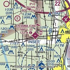
| Sectional chart |
|---|
|
| Airport distance calculator |
|---|
|
|
| Sunrise and sunset |
|---|
|
Times for 27-Nov-2025
| | Local
(UTC-6) | | Zulu
(UTC) |
|---|
| Morning civil twilight | | 06:28 | | 12:28 |
| Sunrise | | 06:59 | | 12:59 |
| Sunset | | 16:20 | | 22:20 |
| Evening civil twilight | | 16:51 | | 22:51 |
|
| Current date and time |
|---|
| Zulu (UTC) | 27-Nov-2025 10:25:39 |
|---|
| Local (UTC-6) | 27-Nov-2025 04:25:39 |
|---|
|
| METAR |
|---|
KENW
6nm S | 270253Z 28022G35KT 10SM SCT035 M01/M07 A2998
|
KRAC
7nm NE | 270953Z AUTO 29015G28KT 10SM BKN033 M02/M09 A3012 RMK AO2 PK WND 30031/0914 SLP207 T10221089
|
KMKE
15nm N | 270952Z 28016G26KT 10SM BKN033 M02/M08 A3009 RMK AO2 PK WND 30029/0900 SLP200 T10221083 $
|
KBUU
15nm W | 270955Z AUTO 30016G23KT 10SM OVC030 M02/M09 A3013 RMK AO2 T10251086 PWINO
|
KUGN
18nm S | 270951Z AUTO 30016G30KT 10SM OVC034 M02/M09 A3011 RMK AO2 PK WND 29034/0903 SLP211 T10221094
|
K57C
19nm W | 270955Z AUTO 30020G32KT 10SM OVC031 M03/M09 A3012 RMK AO2 T10281091
|
|
| TAF |
|---|
KENW
6nm S | 270539Z 2706/2806 29017G27KT P6SM BKN035 FM271200 30017G27KT P6SM BKN027 FM271600 30018G28KT P6SM SCT035 FM272300 30013G24KT P6SM BKN027 FM280200 31011G20KT P6SM SCT035 AMD NOT SKED TIL 271300
|
KMKE
15nm N | 270539Z 2706/2812 29018G31KT P6SM BKN035 FM271200 30017G28KT P6SM SCT027 BKN035 FM280000 30014G23KT P6SM SCT027 FM280600 31011G20KT P6SM SCT035
|
|
| NOTAMs |
|---|
NOTAMs are issued by the DoD/FAA and will open in a separate window not controlled by AirNav.
|
|

