FAA INFORMATION EFFECTIVE 16 APRIL 2026
Location
| FAA Identifier: | BUU |
| Lat/Long: | 42-41-26.5816N 088-18-16.8571W
42-41.443027N 088-18.280952W
42.6907171,-88.3046825
(estimated) |
| Elevation: | 780.1 ft. / 237.8 m (surveyed) |
| Variation: | 03W (2015) |
| From city: | 1 mile NW of BURLINGTON, WI |
| Time zone: | UTC -5 (UTC -6 during Standard Time) |
| Zip code: | 53105 |
Airport Operations
| Airport use: | Open to the public |
| Activation date: | 06/1963 |
| Control tower: | no |
| ARTCC: | CHICAGO CENTER |
| FSS: | GREEN BAY FLIGHT SERVICE STATION |
| NOTAMs facility: | BUU (NOTAM-D service available) |
| Attendance: | 0800-DUSK |
| Wind indicator: | lighted |
| Segmented circle: | yes |
| Lights: | MIRL RWY 11/29 PRESET TO LOW SS-SR; TO INCR INTST & ACTVT REIL RWY 11 & 29; MIRL RWY 11/29 - CTAF. PAPI RWY 11 & 29 OPR CONSLY. |
| Beacon: | white-green (lighted land airport)
Operates sunset to sunrise. |
Airport Communications
| CTAF/UNICOM: | 123.05 |
| WX AWOS-3: | 125.275 (262-757-0907) |
| MILWAUKEE APPROACH: | 135.875 |
| MILWAUKEE DEPARTURE: | 135.875 |
| GOPAC STAR: | 126.5 |
| WX AWOS-3PT at 57C (7 nm NW): | 118.125 (262-642-1845) |
| WX ASOS at ENW (18 nm E): | PHONE 262-652-7730 |
Nearby radio navigation aids
| VOR radial/distance | | VOR name | | Freq | | Var |
|---|
| BAEr180/25.6 | | BADGER VOR/DME | | 116.40 | | 02E |
| OBKr333/32.2 | | NORTHBROOK VOR/DME | | 113.00 | | 02W |
| JVLr074/36.2 | | JANESVILLE VOR/DME | | 114.30 | | 03E |
| NDB name | | Hdg/Dist | | Freq | | Var | | ID |
|---|
| ROCK RIVER | | 148/34.4 | | 371 | | 01W | | RYV | .-. -.-- ...- |
Airport Services
| Fuel available: | 100LL JET-A+
100LL:24 HR SELF SVC FUEL AVBL WITH CREDIT CARD. |
| Parking: | hangars and tiedowns |
| Airframe service: | MAJOR |
| Powerplant service: | MAJOR |
| Bottled oxygen: | LOW |
| Bulk oxygen: | NONE |
Runway Information
Runway 11/29
| Dimensions: | 4300 x 75 ft. / 1311 x 23 m |
| Surface: | asphalt, in good condition |
| Weight bearing capacity: | |
| Runway edge lights: | medium intensity |
| RUNWAY 11 | | RUNWAY 29 |
| Latitude: | 42-41.611898N | | 42-41.383988N |
| Longitude: | 088-18.766845W | | 088-17.858257W |
| Elevation: | 777.4 ft. | | 775.7 ft. |
| Traffic pattern: | left | | right |
| Runway heading: | 112 magnetic, 109 true | | 292 magnetic, 289 true |
| Markings: | nonprecision, in fair condition | | nonprecision, in fair condition |
| Visual slope indicator: | 2-light PAPI on left (3.50 degrees glide path) | | 2-light PAPI on left (3.25 degrees glide path) |
| Runway end identifier lights: | yes | | yes |
| Touchdown point: | yes, no lights | | yes, no lights |
Runway 1/19
| Dimensions: | 2410 x 130 ft. / 735 x 40 m |
| Surface: | turf, in good condition |
| Runway edge markings: | MKD WITH YELLOW/BLACK WOODEN PANELS. |
| RUNWAY 1 | | RUNWAY 19 |
| Latitude: | 42-41.150655N | | 42-41.539430N |
| Longitude: | 088-18.278197W | | 088-18.170942W |
| Elevation: | 772.9 ft. | | 775.1 ft. |
| Traffic pattern: | left | | right |
| Runway heading: | 015 magnetic, 012 true | | 195 magnetic, 192 true |
| Runway end identifier lights: | no | | no |
| Touchdown point: | yes, no lights | | yes, no lights |
Airport Ownership and Management from official FAA records
| Ownership: | Publicly-owned |
| Owner: | CITY OF BURLINGTON
CITY HALL 300 N PINE
BURLINGTON, WI 53105
Phone 262-763-3717 |
| Manager: | PAUL AYDT
707 AIRPORT DRIVE
BURLINGTON, WI 53105
Phone 262-342-5003
EMAIL ADDRESS: PAYDT@BURLINGTON-WI.GOV. |
Additional Remarks
| - | ASPH TWY 30 FT WIDE, EXCEPT 'W' 700 FT 35 FT WIDE. |
| - | DEPARTING TFC CLIMB TO 1000 FT AGL BEFORE TURNING SOUTH. |
| - | WATERFOWL ON & INVOF ARPT. |
| - | TFC DEPARTING RY 11 AVOID OVERFLIGHT OF CITY. |
| - | GCO AVBL ON FREQ 121.725 THRU FLT SVCS. |
| - | FOR CD CTC CHICAGO ARTCC AT 630-906-8921. |
Instrument Procedures
NOTE: All procedures below are presented as PDF files. If you need a reader for these files, you should download the free Adobe Reader.NOT FOR NAVIGATION. Please procure official charts for flight.
FAA instrument procedures published for use from 16 April 2026 at 0901Z to 14 May 2026 at 0900Z.
STARs - Standard Terminal Arrivals |
|---|
| GOPAC THREE (RNAV) | |
download (234KB) |
IAPs - Instrument Approach Procedures |
|---|
| RNAV (GPS) RWY 11 | |
download (199KB) |
| RNAV (GPS) RWY 29 | |
download (205KB) |
| VOR-A | |
download (174KB) |
| NOTE: Special Alternate Minimums apply | |
download (140KB) |
Departure Procedures |
|---|
| ACCRA FIVE (RNAV) | |
download (172KB) |
| UECKR SIX (RNAV) | |
download (189KB) |
| NOTE: Special Take-Off Minimums/Departure Procedures apply | |
download (207KB) |
Other nearby airports with instrument procedures:
57C - East Troy Municipal Airport (7 nm NW)
10C - Galt Field Airport (18 nm S)
KENW - Kenosha Regional Airport (18 nm E)
KUES - Waukesha County Airport (21 nm N)
KRAC - Batten International Airport (22 nm E)
|
|

Road maps at:
MapQuest
Bing
Google
| Aerial photo |
|---|
WARNING: Photo may not be current or correct
 Photo taken 12-May-2012
looking west-southwest.
Photo taken 12-May-2012
looking west-southwest.
Do you have a better or more recent aerial photo of Burlington Municipal Airport that you would like to share? If so, please send us your photo.
|
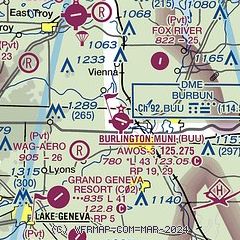
| Sectional chart |
|---|
|
| Airport distance calculator |
|---|
|
|
| Sunrise and sunset |
|---|
|
Times for 05-May-2026
| | Local
(UTC-5) | | Zulu
(UTC) |
|---|
| Morning civil twilight | | 05:12 | | 10:12 |
| Sunrise | | 05:43 | | 10:43 |
| Sunset | | 19:57 | | 00:57 |
| Evening civil twilight | | 20:28 | | 01:28 |
|
| Current date and time |
|---|
| Zulu (UTC) | 05-May-2026 14:02:49 |
|---|
| Local (UTC-5) | 05-May-2026 09:02:49 |
|---|
|
| METAR |
|---|
| KBUU | 051335Z AUTO 28008G15KT 10SM CLR 10/M03 A2979 RMK AO2 T01041031 PWINO
|
K57C
7nm NW | 051355Z AUTO 28011G20KT 10SM CLR 10/M03 A2978 RMK AO2 T00971026
|
KENW
17nm E | 051353Z AUTO 29011KT 10SM CLR 09/M03 A2979 RMK AO2 SLP087 T00941033
|
|
| TAF |
|---|
KENW
17nm E | 051120Z 0512/0612 31007KT P6SM BKN230 FM060300 VRB03KT P6SM BKN230 FM061100 32005KT P6SM FEW230
|
KUES
21nm N | 051120Z 0512/0612 29005KT P6SM BKN240 FM051700 28010KT P6SM BKN230 FM060000 31005KT P6SM BKN220 FM060300 00000KT P6SM SCT230
|
|
| NOTAMs |
|---|
NOTAMs are issued by the DoD/FAA and will open in a separate window not controlled by AirNav.
|
|

