FAA INFORMATION EFFECTIVE 20 MARCH 2025
Location
| FAA Identifier: | CTZ |
| Lat/Long: | 34-58-29.7670N 078-21-56.2680W
34-58.496117N 078-21.937800W
34.9749353,-78.3656300
(estimated) |
| Elevation: | 144 ft. / 43.9 m (surveyed) |
| Variation: | 09W (2005) |
| From city: | 2 miles SW of CLINTON, NC |
| Time zone: | UTC -4 (UTC -5 during Standard Time) |
| Zip code: | 28328 |
Airport Operations
| Airport use: | Open to the public |
| Control tower: | no |
| ARTCC: | WASHINGTON CENTER |
| FSS: | RALEIGH FLIGHT SERVICE STATION |
| NOTAMs facility: | CTZ (NOTAM-D service available) |
| Attendance: | MON-SAT 0830-1800, ALL SUN 1300-1800
FOR ARPT ATTENDANT AFTER HRS CALL 910-592-3295 OR 910-590-9100. |
| Wind indicator: | lighted |
| Segmented circle: | yes |
| Lights: | ACTVT REIL RWY 06 & 24 - CTAF. PAPI RWY 06 & 24 ON 24 HRS. MIRL RWY 06/24 DUSK-DAWN. |
| Beacon: | white-green (lighted land airport)
Operates sunset to sunrise. |
Airport Communications
| CTAF/UNICOM: | 122.8 |
| WX AWOS-3: | 119.125 (910-592-7488) |
| FAYETTEVILLE APPROACH: | 133.0 |
| FAYETTEVILLE DEPARTURE: | 133.0 |
| WX AWOS-3 at DPL (19 nm E): | 120.675 (910-296-9688) |
Nearby radio navigation aids
| VOR radial/distance | | VOR name | | Freq | | Var |
|---|
| FAYr095/25.1 | | FAYETTEVILLE VOR/DME | | 114.85 | | 04W |
| NDB name | | Hdg/Dist | | Freq | | Var | | ID |
|---|
| CLINTON | | at field | | 412 | | 09W | | CTZ | -.-. - --.. |
| HARNETT | | 159/31.4 | | 417 | | 08W | | HQT | .... --.- - |
Airport Services
| Fuel available: | 100LL JET-A1+ |
| Parking: | tiedowns |
| Airframe service: | MAJOR |
| Powerplant service: | MAJOR |
| Bottled oxygen: | NONE |
| Bulk oxygen: | NONE |
Runway Information
Runway 6/24
| Dimensions: | 5008 x 75 ft. / 1526 x 23 m |
| Surface: | asphalt, in good condition |
| Weight bearing capacity: | |
| Runway edge lights: | medium intensity |
| RUNWAY 6 | | RUNWAY 24 |
| Latitude: | 34-58.236248N | | 34-58.755950N |
| Longitude: | 078-22.327388W | | 078-21.548175W |
| Elevation: | 129.8 ft. | | 143.8 ft. |
| Traffic pattern: | left | | left |
| Runway heading: | 060 magnetic, 051 true | | 240 magnetic, 231 true |
| Markings: | nonprecision, in good condition | | nonprecision, in good condition |
| Visual slope indicator: | 2-light PAPI on left (3.00 degrees glide path) | | 2-light PAPI on left (3.00 degrees glide path) |
| Runway end identifier lights: | yes | | yes |
| Touchdown point: | yes, no lights | | yes, no lights |
| Instrument approach: | LOCALIZER | | |
| Obstructions: | 21 ft. trees, 348 ft. from runway, 368 ft. left of centerline, 7:1 slope to clear | | 10 ft. trees, 246 ft. from runway, 176 ft. right of centerline, 4:1 slope to clear
HAS 79 FT TO 40 FT TREES 0-200 FT FM THR 278 FT RIGHT OF CNTRLN AND 81 FT TREES 102 FT FM THR 357 FT LEFT OF CNTRLN. |
Airport Ownership and Management from official FAA records
| Ownership: | Publicly-owned |
| Owner: | SAMPSON COUNTY/CITY OF CLINTON
221 LISBON STREET
CLINTON, NC 28328
Phone 910-592-1961 |
| Manager: | JAMES DUNCAN
89 SAMPSON AIRPORT ROAD
CLINTON, NC 28328
Phone 910-592-3295
FBO-CLINTON FLYING SERVICE - JIM NAYLOR. |
Additional Remarks
| - | 50 FT TREES 300 FT FM CNTRLN PENETRATE TRANSITIONAL SFC NW SIDE OF RWY FM RWY 24 APCH SFC TO RWY 06 THR. |
| - | 40 FT DROP-OFF RWY 06 325 FT FROM THR & 120 FT LEFT. 60+ FT DROP-OFF 20 FT FM THR & 110 FT RIGHT OF CNTRLN. |
| - | 30 FT DROP-OFF RWY 24 350 FT FM THR & 175 FT RIGHT OF CNTRLN. |
| - | TWY A AT RWY 06 HAS 70 FT DROP-OFF 50 FT TO 100 FT LEFT OF CNTRLN. |
Instrument Procedures
NOTE: All procedures below are presented as PDF files. If you need a reader for these files, you should download the free Adobe Reader.NOT FOR NAVIGATION. Please procure official charts for flight.
FAA instrument procedures published for use from 20 March 2025 at 0901Z to 17 April 2025 at 0900z.
IAPs - Instrument Approach Procedures |
|---|
| RNAV (GPS) RWY 06 | |
download (194KB) |
| RNAV (GPS) Y RWY 24 | |
download (199KB) |
| RNAV (GPS) Z RWY 24 | |
download (190KB) |
| VOR/DME-A | |
download (182KB) |
| NOTE: Special Alternate Minimums apply | |
download (167KB) |
| NOTE: Special Take-Off Minimums/Departure Procedures apply | |
download (141KB) |
Other nearby airports with instrument procedures:
KDPL - Duplin County Airport (19 nm E)
W40 - Mount Olive Municipal Airport (22 nm NE)
KACZ - Wallace-Pender Airport (24 nm SE)
KEYF - Curtis L Brown Jr. Field Airport (25 nm SW)
KFAY - Fayetteville Regional Airport/Grannis Field (25 nm W)
|
|

Road maps at:
MapQuest
Bing
Google
| Aerial photo |
|---|
WARNING: Photo may not be current or correct

Do you have a better or more recent aerial photo of Clinton-Sampson County Airport that you would like to share? If so, please send us your photo.
|
| Sectional chart |
|---|
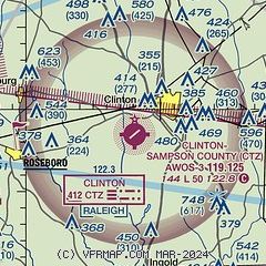
|
| Airport distance calculator |
|---|
|
|
| Sunrise and sunset |
|---|
|
Times for 13-Apr-2025
| | Local
(UTC-4) | | Zulu
(UTC) |
|---|
| Morning civil twilight | | 06:19 | | 10:19 |
| Sunrise | | 06:45 | | 10:45 |
| Sunset | | 19:43 | | 23:43 |
| Evening civil twilight | | 20:09 | | 00:09 |
|
| Current date and time |
|---|
| Zulu (UTC) | 13-Apr-2025 10:45:22 |
|---|
| Local (UTC-4) | 13-Apr-2025 06:45:22 |
|---|
|
| METAR |
|---|
| KCTZ | 131025Z AUTO 00000KT 10SM CLR 04/04 A3008 RMK AO2 T00420042
|
KDPL
20nm E | 131030Z AUTO 29003KT 10SM CLR 04/03 A3007 RMK AO2
|
|
| TAF |
|---|
KFAY
25nm W | 130529Z 1306/1406 33004KT P6SM FEW070
|
KFBG
28nm W | 130900Z 1309/1415 33006KT 9999 FEW030 QNH3006INS BECMG 1410/1411 27006KT 9999 FEW090 QNH3007INS BECMG 1414/1415 23010G15KT 9999 SKC QNH3006INS TX16/1317Z TN05/1310Z
|
|
| NOTAMs |
|---|
NOTAMs are issued by the DoD/FAA and will open in a separate window not controlled by AirNav.
|
|


