FAA INFORMATION EFFECTIVE 16 APRIL 2026
Location
| FAA Identifier: | DAB |
| Lat/Long: | 29-10-47.6720N 081-03-28.9520W
29-10.794533N 081-03.482533W
29.1799089,-81.0580422
(estimated) |
| Elevation: | 34.2 ft. / 10.4 m (surveyed) |
| Variation: | 05W (2000) |
| From city: | 3 miles SW of DAYTONA BEACH, FL |
| Time zone: | UTC -4 (UTC -5 during Standard Time) |
| Zip code: | 32114 |
Airport Operations
| Airport use: | Open to the public |
| Activation date: | 04/1940 |
| Control tower: | yes |
| ARTCC: | JACKSONVILLE CENTER |
| FSS: | SAINT PETERSBURG FLIGHT SERVICE STATION |
| NOTAMs facility: | DAB (NOTAM-D service available) |
| Attendance: | CONTINUOUS |
| Pattern altitude: | 999.2 ft. MSL
TPA FOR LGT ACFT 965 FT AGL; TPA FOR HI PER ACFT 1365 FT AGL. |
| Wind indicator: | lighted |
| Segmented circle: | no |
| Lights: | SS-SR |
| Beacon: | white-green (lighted land airport)
Operates sunset to sunrise. |
| Fire and rescue: | ARFF index C |
| International operations: | US CUSTOMS USER FEE ARPT. |
Airport Communications
| UNICOM: | 122.95 |
| ATIS: | 132.875 |
| WX ASOS: | PHONE 386-232-5134 |
| DAYTONA GROUND: | 121.9 348.6 |
| DAYTONA TOWER: | 120.7 257.8 |
| DAYTONA APPROACH: | 118.85 ;N 4000-7500 125.35 ;S 3500 FT & BLW 125.725 ;8000-11000 FT 125.8 ;N 3500 FT & BLW 127.075 ;S 4000-7500 269.075 ;N 3500 FT & BLW 322.3 ;S 3500 FT & BLW 351.95 ;S 4000-8500 351.95 ;S 4000-8500 353.825 ;N 4000-8500 379.95 ;9000 FT & ABV |
| DAYTONA DEPARTURE: | 319.15 351.95 ;S 4000-8500 |
| CLEARANCE DELIVERY: | 119.3 |
| CLASS C: | 125.35 ;S 3500 FT & BLW 125.8 ;N 3500 FT & BLW 269.075 ;N 3500 FT & BLW 322.3 ;S 3500 FT & BLW |
| EMERG: | 121.5 243.0 |
| IC: | 125.8 ;N 3500 FT & BLW 269.075 ;N 3500 FT & BLW 379.95 ;9000 FT & ABV |
| LAMMA DP: | 118.85 353.825 |
| ROYES DP: | 118.85 353.825 |
| TTHOR STAR: | 118.85 353.825 |
| WX AWOS-3 at OMN (8 nm N): | 118.475 (386-615-7084) |
| WX AWOS-3 at EVB (9 nm SE): | 124.625 (386-409-4705) |
| WX AWOS-3 at DED (14 nm SW): | 119.575 (386-740-5811) |
| WX AWOS-3 at FIN (19 nm NW): | 128.325 (386-437-7334) |
- SAID IN USE. OPERATE TRANSPONDERS WITH ALTITUDE REPORTING MODE AND ADS-B (IF EQUIPPED) ENABLED ON ALL AIRPORT SURFACES.
Nearby radio navigation aids
| VOR radial/distance | | VOR name | | Freq | | Var |
|---|
| OMNr159/7.9 | | ORMOND BEACH VORTAC | | 112.60 | | 00E |
Airport Services
| Fuel available: | 100LL JET-A |
| Parking: | hangars and tiedowns |
| Airframe service: | MAJOR |
| Powerplant service: | MAJOR |
| Bottled oxygen: | NONE |
| Bulk oxygen: | HIGH |
Runway Information
Runway 7L/25R
| Dimensions: | 10500 x 150 ft. / 3200 x 46 m
FIRST 2300 FT RWY 7L CONCRETE ON 50 FT WIDE KEEL SECTION. |
| Surface: | asphalt/concrete/grooved, in good condition |
| Weight bearing capacity: | | Single wheel: | 120.0 | | Double wheel: | 214.0 | | Double tandem: | 406.0 | | Dual double tandem: | 919.0 |
|
| Runway edge lights: | high intensity |
| RUNWAY 7L | | RUNWAY 25R |
| Latitude: | 29-10.352990N | | 29-11.079097N |
| Longitude: | 081-04.667263W | | 081-02.874928W |
| Elevation: | 28.3 ft. | | 32.7 ft. |
| Traffic pattern: | left | | right |
| Runway heading: | 070 magnetic, 065 true | | 250 magnetic, 245 true |
| Displaced threshold: | 690 ft. | | no |
| Declared distances: | TORA:10500 TODA:10500 ASDA:10500 LDA:9810 | | TORA:10500 TODA:10500 ASDA:10293 LDA:10293 |
| Markings: | precision, in good condition | | precision, in good condition |
| Visual slope indicator: | | | 4-light PAPI on left (3.00 degrees glide path)
PAPI UNUSBL BYD 5 DEG LEFT & RIGHT OF CNTRLN. |
| RVR equipment: | touchdown | | rollout |
| Approach lights: | MALSR: 1,400 foot medium intensity approach lighting system with runway alignment indicator lights | | MALSR: 1,400 foot medium intensity approach lighting system with runway alignment indicator lights |
| Runway end identifier lights: | no | | no |
| Centerline lights: | yes | | yes |
| Touchdown point: | yes, lighted | | yes, no lights |
| Instrument approach: | LOC/GS | | ILS/DME |
| Obstructions: | 15 ft. road, 790 ft. from runway, 500 ft. left of centerline, 39:1 slope to clear
RWY 07L APCH SLP 50:1 TO DSPLCD THR. | | 43 ft. trees, 2370 ft. from runway, 230 ft. left of centerline |
Runway 16/34
| Dimensions: | 6001 x 150 ft. / 1829 x 46 m |
| Surface: | asphalt/grooved, in fair condition |
| Weight bearing capacity: | | Single wheel: | 109.0 | | Double wheel: | 191.0 | | Double tandem: | 355.0 | | Dual double tandem: | 750.0 |
|
| Runway edge lights: | medium intensity |
| RUNWAY 16 | | RUNWAY 34 |
| Latitude: | 29-11.452895N | | 29-10.540258N |
| Longitude: | 081-03.379863W | | 081-02.942227W |
| Elevation: | 30.8 ft. | | 32.5 ft. |
| Traffic pattern: | left | | left |
| Runway heading: | 162 magnetic, 157 true | | 342 magnetic, 337 true |
| Declared distances: | TORA:6001 TODA:6001 ASDA:5969 LDA:5969 | | TORA:6001 TODA:6001 ASDA:6001 LDA:6001 |
| Markings: | nonprecision, in good condition | | nonprecision, in good condition |
| Visual slope indicator: | 4-light PAPI on left (3.00 degrees glide path) | | 4-light PAPI on left (3.00 degrees glide path) |
| Runway end identifier lights: | yes | | yes |
| Touchdown point: | yes, no lights | | yes, no lights |
| Obstructions: | 42 ft. trees, 1630 ft. from runway, 275 ft. left of centerline, 34:1 slope to clear | | 46 ft. trees, 1130 ft. from runway, 400 ft. left of centerline, 20:1 slope to clear |
Runway 7R/25L
| Dimensions: | 3195 x 100 ft. / 974 x 30 m |
| Surface: | asphalt, in poor condition
OUTER EDGES OF PAVEMENT UNEVEN. |
| Weight bearing capacity: | | Single wheel: | 26.0 | | Double wheel: | 44.0 |
|
| Runway edge lights: | medium intensity |
| Operational restrictions: | RWY 07R/25L NOT AVBL FOR PART 121/PART 380 OPS WITH SKED PAX CARRYING OPS MORE THAN 9 PAX SEATS AND NON-SKED PAX CARRYING OPS MORE THAN 30 PAX SEATS. |
| RUNWAY 7R | | RUNWAY 25L |
| Latitude: | 29-10.561937N | | 29-10.783563N |
| Longitude: | 081-03.410490W | | 081-02.865390W |
| Elevation: | 28.5 ft. | | 32.3 ft. |
| Traffic pattern: | right | | left |
| Runway heading: | 070 magnetic, 065 true | | 250 magnetic, 245 true |
| Declared distances: | TORA:3195 TODA:3195 ASDA:3195 LDA:3195 | | TORA:3195 TODA:3195 ASDA:3195 LDA:3195 |
| Markings: | nonprecision, in good condition | | nonprecision, in good condition |
| Visual slope indicator: | 2-light PAPI on left (3.00 degrees glide path) | | 2-light PAPI on left (3.00 degrees glide path) |
| Runway end identifier lights: | yes | | yes |
| Touchdown point: | yes, no lights | | yes, no lights |
| Obstructions: | 55 ft. trees, 1580 ft. from runway, 185 ft. left of centerline, 25:1 slope to clear | | 42 ft. trees, 1485 ft. from runway, 105 ft. left of centerline, 30:1 slope to clear |
Airport Ownership and Management from official FAA records
| Ownership: | Publicly-owned |
| Owner: | VOLUSIA COUNTY
123 W INDIANA AVE
DELAND, FL 32720-4612
Phone 386-248-8030 |
| Manager: | MS KAREN K FEASTER, AAE, IACE, ACE
700 CATALINA DR, SUITE 300, DAYTONA BEACH INTL ARPT
DAYTONA BEACH, FL 32114
Phone 386-248-8030 |
Additional Remarks
| A39-07R/25L | PCR VALUE: 90/F/C/X/T |
| A39-16/34 | PCR VALUE: 420/F/A/X/T |
| A39-07L/25R | PCR VALUE: 650/R/A/W/T |
| - | HVY MIGRATORY BIRD ACT ON & INVOF ARPT. |
| - | USE CO FLY QUIET PROC OR RCMD NOISE ABATEMENT PROC - AMGR. |
| - | AIRFIELD SFC CONDS ARE NOT MNTD BTN THE HRS OF 0000-0400. |
| - | ROTOR WING HEL MUST GRND TAXI; IF UNABL USE CTN DURG HOVER TAXI. |
| - | US CUSTS RAMP RSTRD GROUP II ACFT OF WINGSPAN 79 FT OR LESS. |
| - | E END OF TWY S IS NON-MOVEMENT AREA. |
| - | TWY C1 CLSD TO ACFT WINGSPAN MORE THAN 119 FT; TWY W CLSD TO ACFT WINGSPAN MORE THAN 119 FT; TWY W3 CLSD TO ACFT WINGSPAN MORE THAN 79 FT. |
| - | TWY W BTN RWY 16 APCH END & TWY A CLSD TO MIL HEL & HOVER TAXI OPS. |
| - | TWY W BTN TWY A & RWY 16 APCH END CLSD TO ROTARY WING WITH ROTAR SPAN MORE THAN 50 FT EXC 1 HR PPR - 386-527-0657. |
| - | ALL MIL OPS REQ 24 HR. ADVND CDN WITH ARPT OPNS - PPR (386) 527-0657. |
| - | ALL HELO OPS EXPC TWY W BTN TWY A & RWY 16 APCH END CLSD TO ROTARY WING ACFT WITH ROTAR SPAN MORE THAN 50 FT EXC 1 HR. PPR (386) 527-0657. |
| - | INCRD DRONE ACT NE OF ARPT. |
| - | HVY BIRD ACTIVITY OVER LANDFILL LOCATED 3.5NM SW OF THE AIRFIELD. |
| - | PPR FOR DAYTONA BEACH SPEEDWAY LOW APCH OR FLY-OVER. CTC ATC FOR PMSN. |
| - | RWY 07L LEAD-OFF LINES FOR TWY P3 AND TWY P4 FOR GROUP I ACFT ONLY WITH WINGSPAN OF LESS THAN 49 FT. |
| - | WX MOD GEO ENGINEERING ACFT NOTIFY AP OPS 24 HRS PRIOR TO ARR/DEP 386-527-0657. |
| - | TWY E RSTRD TO 22000 LBS MAX CRTFYD GROSS TKOF WEIGHT; TWY P RSTRD TO 190500 LBS MAX CRTFYD GROSS TKOF WEIGHT. |
| - | TWY "N" N OF RY 7L-25R CAN BE MISTAKEN FOR THE RY & APCH ENVIRONMENT. |
Instrument Procedures
NOTE: All procedures below are presented as PDF files. If you need a reader for these files, you should download the free Adobe Reader.NOT FOR NAVIGATION. Please procure official charts for flight.
FAA instrument procedures published for use from 16 April 2026 at 0901Z to 14 May 2026 at 0900Z.
STARs - Standard Terminal Arrivals |
|---|
| TTHOR THREE (RNAV) | |
2 pages:
[1] [2] (335KB) |
IAPs - Instrument Approach Procedures |
|---|
| ILS OR LOC RWY 07L | |
download (314KB) |
| ILS OR LOC RWY 25R | |
download (314KB) |
| RNAV (GPS) RWY 07L | |
download (253KB) |
| RNAV (GPS) RWY 07R | |
download (204KB) |
| RNAV (GPS) RWY 16 | |
download (231KB) |
| RNAV (GPS) RWY 25R | |
download (240KB) |
| RNAV (GPS) RWY 34 | |
download (219KB) |
| NOTE: Special Alternate Minimums apply | |
download |
Departure Procedures |
|---|
| ROYES SEVEN | |
download (214KB) |
| NOTE: Special Take-Off Minimums/Departure Procedures apply | |
download (162KB) |
Other nearby airports with instrument procedures:
7FL6 - Spruce Creek Airport (6 nm S)
KOMN - Ormond Beach Municipal Airport (8 nm N)
KEVB - New Smyrna Beach Municipal Airport (Jack Bolt Field) (9 nm SE)
KDED - DeLand Municipal Airport-Sidney H Taylor Field (14 nm SW)
X50 - Massey Ranch Airpark (14 nm SE)
KFIN - Flagler Executive Airport (19 nm NW)
|
|

Road maps at:
MapQuest
Bing
Google
| Aerial photo |
|---|
WARNING: Photo may not be current or correct
 Photo by Dave Fogarty DPE/ATP/CFI/A&P-IA/FAAST
Photo taken 30-Jan-2019
looking south-southeast from 9,000 MSL
Photo by Dave Fogarty DPE/ATP/CFI/A&P-IA/FAAST
Photo taken 30-Jan-2019
looking south-southeast from 9,000 MSL
Do you have a better or more recent aerial photo of Daytona Beach International Airport that you would like to share? If so, please send us your photo.
|
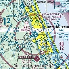
| Sectional chart |
|---|
|
CAUTION: Diagram may not be current
 Download PDF
of official airport diagram from the FAA
| Airport distance calculator |
|---|
|
|
| Sunrise and sunset |
|---|
|
Times for 02-May-2026
| | Local
(UTC-4) | | Zulu
(UTC) |
|---|
| Morning civil twilight | | 06:18 | | 10:18 |
| Sunrise | | 06:43 | | 10:43 |
| Sunset | | 20:00 | | 24:00 |
| Evening civil twilight | | 20:25 | | 00:25 |
|
| Current date and time |
|---|
| Zulu (UTC) | 03-May-2026 02:30:44 |
|---|
| Local (UTC-4) | 02-May-2026 22:30:44 |
|---|
|
| METAR |
|---|
| KDAB | 030153Z 35011KT 6SM -RA BR SCT008 BKN015 OVC030 20/19 A2990 RMK AO2 RAB35 SLP125 P0001 T02000189 $
|
KOMN
8nm NW | 022250Z 25007KT 7SM OVC070 22/22 A2983 RMK LAST
|
KEVB
9nm SE | 030147Z 29006KT 8SM BKN100 21/21 A2987 RMK LAST
|
KDED
14nm SW | 030155Z AUTO 34009KT 7SM -RA BR SCT008 BKN019 OVC027 20/18 A2992 RMK AO2 P0001 T01990185
|
KFIN
19nm NW | 030155Z AUTO 34010G18KT 5SM BR OVC009 19/18 A2992 RMK AO2 P0002 T01860178
|
|
| TAF |
|---|
| KDAB | 022114Z 0221/0318 26015G24KT P6SM VCSH FEW015 SCT040 BKN130 TEMPO 0221/0222 -SHRA BKN070 FM022300 29015KT P6SM VCSH BKN020 BKN050 BKN180 FM030800 35010KT P6SM SCT030 SCT050 SCT080 FM031400 03013G19KT P6SM FEW020 SCT060 SCT250
|
|
| NOTAMs |
|---|
NOTAMs are issued by the DoD/FAA and will open in a separate window not controlled by AirNav.
|
|


