FAA INFORMATION EFFECTIVE 20 FEBRUARY 2025
Location
| FAA Identifier: | GSH |
| Lat/Long: | 41-31-34.0803N 085-47-39.3726W
41-31.568005N 085-47.656210W
41.5261334,-85.7942702
(estimated) |
| Elevation: | 826.6 ft. / 251.9 m (surveyed) |
| Variation: | 04W (2000) |
| From city: | 3 miles SE of GOSHEN, IN |
| Time zone: | UTC -5 (UTC -4 during Daylight Saving Time) |
| Zip code: | 46526 |
Airport Operations
| Airport use: | Open to the public |
| Activation date: | 06/1941 |
| Control tower: | no |
| ARTCC: | CHICAGO CENTER |
| FSS: | TERRE HAUTE FLIGHT SERVICE STATION |
| NOTAMs facility: | GSH (NOTAM-D service available) |
| Attendance: | MON-SAT 0700-1800, ALL SUN 0900-1700 |
| Wind indicator: | lighted |
| Segmented circle: | no |
| Lights: | ACTVT REIL RWY 09 & 27; PAPI RWY 09 & 27 - CTAF. HIRL RWY 09/27 PRESET LOW INTST; INCR INTST - CTAF. |
| Beacon: | white-green (lighted land airport)
Operates sunset to sunrise. |
Airport Communications
| CTAF/UNICOM: | 123.05 |
| WX ASOS: | 121.45 (574-642-4231) |
| SOUTH BEND APPROACH: | 132.05 |
| SOUTH BEND DEPARTURE: | 132.05 |
| CLEARANCE DELIVERY: | 125.25 ;CTC APCH CTL |
| WX AWOS-3 at EKM (15 nm NW): | 124.475 (574-264-9002) |
| WX AWOS-3 at ASW (15 nm S): | 121.125 (574-269-7035) |
- APCH/DEP SVC PRVDD BY CHICAGO ARTCC ON FREQS 135.9/314.0 (GOSHEN RCAG) WHEN SOUTH BEND APCH CTL CLSD.
Nearby radio navigation aids
| VOR radial/distance | | VOR name | | Freq | | Var |
|---|
| GSHr090/10.5 | | GOSHEN VORTAC | | 113.70 | | 00E |
| OLKr324/(21.4) | | WEBSTER LAKE VOR | | 110.40 | | 03W |
| GIJr122/27.6 | | GIPPER VORTAC | | 115.40 | | 00E |
| ELXr158/39.9 | | KEELER VOR/DME | | 116.60 | | 00E |
| NDB name | | Hdg/Dist | | Freq | | Var | | ID |
|---|
| STURGIS | | 227/23.6 | | 382 | | 04W | | IRS | .. .-. ... |
Airport Services
| Fuel available: | 100LL JET-A |
| Parking: | hangars and tiedowns |
| Airframe service: | MAJOR |
| Powerplant service: | MAJOR |
| Bottled oxygen: | HIGH |
Runway Information
Runway 9/27
| Dimensions: | 6050 x 100 ft. / 1844 x 30 m |
| Surface: | asphalt/grooved, in good condition |
| Weight bearing capacity: | | Single wheel: | 45.0 | | Double wheel: | 60.0 | | Double tandem: | 100.0 |
|
| Runway edge lights: | high intensity |
| RUNWAY 9 | | RUNWAY 27 |
| Latitude: | 41-31.513282N | | 41-31.525638N |
| Longitude: | 085-48.332217W | | 085-47.006703W |
| Elevation: | 819.6 ft. | | 826.4 ft. |
| Traffic pattern: | left | | left |
| Runway heading: | 093 magnetic, 089 true | | 273 magnetic, 269 true |
| Markings: | nonprecision, in fair condition | | precision, in fair condition |
| Visual slope indicator: | 2-light PAPI on left (3.50 degrees glide path) | | 4-light PAPI on left (3.00 degrees glide path) |
| Runway end identifier lights: | yes | | yes |
| Touchdown point: | yes, no lights | | yes, no lights |
| Instrument approach: | | | ILS |
| Obstructions: | 59 ft. tree, 1976 ft. from runway, 117 ft. right of centerline, 30:1 slope to clear | | 83 ft. tree, 3630 ft. from runway, 210 ft. right of centerline, 44:1 slope to clear |
Runway 5/23
| Dimensions: | 2267 x 180 ft. / 691 x 55 m |
| Surface: | turf, in good condition |
| Runway edge markings: | YELLOW CONES. |
| RUNWAY 5 | | RUNWAY 23 |
| Latitude: | 41-31.563997N | | 41-31.831115N |
| Longitude: | 085-47.794378W | | 085-47.447325W |
| Elevation: | 814.1 ft. | | 822.3 ft. |
| Traffic pattern: | left | | left |
| Runway heading: | 048 magnetic, 044 true | | 228 magnetic, 224 true |
| Markings: | none | | none |
| Runway end identifier lights: | no | | no |
| Touchdown point: | yes, no lights | | yes, no lights |
| Obstructions: | none | | 105 ft. pline, 4020 ft. from runway, 38:1 slope to clear |
Airport Ownership and Management from official FAA records
| Ownership: | Publicly-owned |
| Owner: | GOSHEN BOAC
202 S 5TH ST
GOSHEN, IN 46526
Phone (574) 533-8245 |
| Manager: | RANDY SHARKEY
17229 CR 42
GOSHEN, IN 46526
Phone 574-238-1000
OR 574-238-1000. ALSO, A 24-HR PHONE AVBL. |
Additional Remarks
| - | FOR CD CTC SOUTH BEND APCH AT 574-251-2609. WHEN SOUTH BEND APCH CLSD, FOR CD CTC CHICAGO ARTCC AT 630-906-8921. |
Instrument Procedures
NOTE: All procedures below are presented as PDF files. If you need a reader for these files, you should download the free Adobe Reader.NOT FOR NAVIGATION. Please procure official charts for flight.
FAA instrument procedures published for use from 20 February 2025 at 0901Z to 20 March 2025 at 0900Z.
IAPs - Instrument Approach Procedures |
|---|
| ILS OR LOC RWY 27 | |
download (295KB) |
| RNAV (GPS) RWY 09 | |
download (227KB) |
| RNAV (GPS) RWY 27 | |
download (286KB) |
| VOR RWY 09 | |
download (194KB) |
| NOTE: Special Alternate Minimums apply | |
download (144KB) |
| NOTE: Special Take-Off Minimums/Departure Procedures apply | |
download (276KB) |
Other nearby airports with instrument procedures:
C03 - Nappanee Municipal Airport (8 nm SW)
KEKM - Elkhart Municipal Airport (15 nm NW)
KASW - Warsaw Municipal Airport (15 nm S)
KIRS - Kirsch Municipal Airport (23 nm NE)
C62 - Kendallville Municipal Airport (24 nm E)
|
|

Road maps at:
MapQuest
Bing
Google
| Aerial photo |
|---|
WARNING: Photo may not be current or correct
 Photo by RJ Monroe
Taken in the Summer of 2016
looking southeast.
Photo by RJ Monroe
Taken in the Summer of 2016
looking southeast.
Do you have a better or more recent aerial photo of Goshen Municipal Airport that you would like to share? If so, please send us your photo.
|
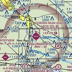
| Sectional chart |
|---|
|
| Airport distance calculator |
|---|
|
|
| Sunrise and sunset |
|---|
|
Times for 13-Mar-2025
| | Local
(UTC-5) | | Zulu
(UTC) |
|---|
| Morning civil twilight | | 06:32 | | 11:32 |
| Sunrise | | 06:59 | | 11:59 |
| Sunset | | 18:46 | | 23:46 |
| Evening civil twilight | | 19:14 | | 00:14 |
|
| Current date and time |
|---|
| Zulu (UTC) | 13-Mar-2025 12:21:30 |
|---|
| Local (UTC-5) | 13-Mar-2025 07:21:30 |
|---|
|
| METAR |
|---|
| KGSH | 131153Z AUTO 00000KT 10SM CLR M02/M05 A2990 RMK AO2 SLP131 T10171050 10006 21022 53014
|
KASW
15nm S | 131155Z AUTO 10004KT 10SM CLR M01/M03 A2990 RMK AO2 T10101038
|
|
| TAF |
|---|
KSBN
26nm NW | 131120Z 1312/1412 10005KT P6SM FEW250
|
|
| NOTAMs |
|---|
NOTAMs are issued by the DoD/FAA and will open in a separate window not controlled by AirNav.
|
|


