FAA INFORMATION EFFECTIVE 09 JULY 2026
Location
| FAA Identifier: | I73 |
| Lat/Long: | 39-40-55.5950N 084-14-23.9700W
39-40.926583N 084-14.399500W
39.6821097,-84.2399917
(estimated) |
| Elevation: | 720 ft. / 219.5 m (surveyed) |
| Variation: | 04W (1985) |
| From city: | 4 miles SW of DAYTON, OH |
| Time zone: | UTC -4 (UTC -5 during Standard Time) |
| Zip code: | 45439 |
Airport Operations
| Airport use: | Open to the public |
| Activation date: | 10/1947 |
| Control tower: | no |
| ARTCC: | INDIANAPOLIS CENTER |
| FSS: | DAYTON FLIGHT SERVICE STATION |
| NOTAMs facility: | DAY (NOTAM-D service available) |
| Attendance: | DAYLIGHT HOURS |
| Wind indicator: | yes |
| Segmented circle: | no |
| Lights: | INCR INTST MIRL RWY 08/26 - CTAF. MIRL RWY 08/26 OPR SS-SR LOW INTST. |
| Beacon: | white-green (lighted land airport)
Operates sunset to sunrise. |
Airport Communications
| CTAF/UNICOM: | 122.7 |
| COLUMBUS APPROACH: | 118.85 134.45 |
| COLUMBUS DEPARTURE: | 118.85 134.45 |
| WX ASOS at MGY (6 nm S): | 118.375 (937-885-2171) |
| WX AWOS-3 at GDK (11 nm E): | 118.525 (937-372-4668) |
| WX AWOS-3PT at MWO (12 nm SW): | 120.025 (513-422-3505) |
| WX AWOS-3PT at I68 (13 nm S): | 120.55 (513-934-5500) |
| WX ASOS at DAY (13 nm N): | PHONE 937-419-1421 |
Nearby radio navigation aids
| VOR radial/distance | | VOR name | | Freq | | Var |
|---|
| DQNr161/21.3 | | DAYTON VOR/DME | | 114.50 | | 01W |
| MXQr311/25.3 | | MIDWEST VOR/DME | | 112.90 | | 04W |
| RODr199/37.5 | | ROSEWOOD VORTAC | | 117.50 | | 05W |
| NDB name | | Hdg/Dist | | Freq | | Var | | ID |
|---|
| ONIDA | | 036/7.3 | | 223 | | 04W | | MW | -- .-- |
| BRUNY | | 162/10.8 | | 315 | | 06W | | AT | .- - |
| SPORTYS | | 002/36.3 | | 245 | | 04W | | PWF | .--. .-- ..-. |
| COURT HOUSE | | 283/39.5 | | 414 | | 06W | | CSS | -.-. ... ... |
Airport Services
| Fuel available: | 100LL
100LL:100LL UNAVBL AFT ATNDD HRS. |
| Parking: | tiedowns |
| Airframe service: | NONE |
| Powerplant service: | NONE |
| Bottled oxygen: | NONE |
| Bulk oxygen: | NONE |
Runway Information
Runway 8/26
| Dimensions: | 3500 x 65 ft. / 1067 x 20 m |
| Surface: | asphalt, in fair condition |
| Runway edge lights: | medium intensity |
| RUNWAY 8 | | RUNWAY 26 |
| Latitude: | 39-40.875000N | | 39-40.978167N |
| Longitude: | 084-14.766167W | | 084-14.032833W |
| Elevation: | 720.0 ft. | | 720.0 ft. |
| Traffic pattern: | left | | left |
| Runway heading: | 084 magnetic, 080 true | | 264 magnetic, 260 true |
| Displaced threshold: | 558 ft. | | 136 ft. |
| Markings: | basic, in fair condition | | basic, in fair condition |
| Runway end identifier lights: | no | | no |
| Touchdown point: | yes, no lights | | yes, no lights |
| Obstructions: | 15 ft. berm, lighted, 201 ft. from runway, 75 ft. left of centerline, 1:1 slope to clear
+15 FT LGTD DIKE, 0-200 FT DIST, 75 FT L TO 85 FT R. | | 6 ft. berm, lighted, 201 ft. from runway, 60 ft. right of centerline, 1:1 slope to clear
6 FT LGTD DIKE, 0-200 FT DIST, 125 FT L TO 120 FT R. |
Airport Ownership and Management from official FAA records
| Ownership: | Publicly-owned |
| Owner: | MONTGOMERY COUNTY
3800 CLEARVIEW AVE
MORAINE, OH 45439-1199
Phone 937-866-2489 |
| Manager: | J R SNYDER
3800 CLEARVIEW AVE
MORAINE, OH 45439-1199
Phone 937-866-2489 |
Additional Remarks
| - | 15 FT LEVEE SOUTH OF & PARL TO RWY. TREES NORTH OF RWY. |
| - | PAEW ADJ TWYS. |
| - | FOR CD CTC COLUMBUS APCH AT 614-338-8537. |
| - | ULTRA-LIGHT ACTVTY. |
| - | +75 FT TREE OVERHANGS PARL TWY BTN TRML & RWY END 26. |
| - | MIL JETS OVR ARPT INBD & OUBD TO/FM KFFO AFB 12 NM NE. |
| - | BIRDS INVOF ARPT. |
Instrument Procedures
NOTE: All procedures below are presented as PDF files. If you need a reader for these files, you should download the free Adobe Reader.NOT FOR NAVIGATION. Please procure official charts for flight.
FAA instrument procedures published for use from 09 July 2026 at 0901Z to 06 August 2026 at 0900Z.
IAPs - Instrument Approach Procedures |
|---|
| RNAV (GPS)-A | |
download (168KB) |
| NOTE: Special Take-Off Minimums/Departure Procedures apply | |
download (474KB) |
Other nearby airports with instrument procedures:
KMGY - Dayton/Wright Brothers Airport (6 nm S)
KGDK - Greene County/Lewis A Jackson Regional Airport (11 nm E)
KMWO - Middletown Regional Airport/Hook Field (12 nm SW)
KFFO - Wright-Patterson Air Force Base (12 nm NE)
I68 - Warren County Airport/John Lane Field (13 nm S)
KDAY - James M Cox Dayton International Airport (13 nm N)
3I7 - Dayton/Phillipsburg Airport (16 nm NW)
|
|

Road maps at:
MapQuest
Bing
Google
| Aerial photo |
|---|
WARNING: Photo may not be current or correct
 Photo taken 01-Aug-2006
from a Cessna 340
Photo taken 01-Aug-2006
from a Cessna 340
Do you have a better or more recent aerial photo of Moraine Air Park that you would like to share? If so, please send us your photo.
|
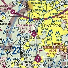
| Sectional chart |
|---|
|
| Airport distance calculator |
|---|
|
|
| Sunrise and sunset |
|---|
|
Times for 27-Jul-2026
| | Local
(UTC-4) | | Zulu
(UTC) |
|---|
| Morning civil twilight | | 06:02 | | 10:02 |
| Sunrise | | 06:33 | | 10:33 |
| Sunset | | 20:54 | | 00:54 |
| Evening civil twilight | | 21:25 | | 01:25 |
|
| Current date and time |
|---|
| Zulu (UTC) | 27-Jul-2026 12:38:14 |
|---|
| Local (UTC-4) | 27-Jul-2026 08:38:14 |
|---|
|
| METAR |
|---|
KMGY
5nm S | 271213Z AUTO 07003KT 3SM BR CLR 21/21 A2994 RMK AO2 T02110206
|
KMWO
12nm SW | 271215Z AUTO 00000KT 4SM HZ SCT002 20/ A2996 RMK AO2
|
KFFO
12nm NE | 271155Z AUTO 00000KT 10SM CLR 21/19 A2993 RMK AO2 SLP131 T02070190 10210 20189 52016
|
KDAY
13nm N | 271156Z 00000KT 7SM CLR 21/19 A2996 RMK AO2 SLP136 T02110194 10211 20189 51014
|
KI68
13nm S | 271215Z AUTO 00000KT 3SM BR CLR 21/21 A2994 RMK AO2
|
|
| TAF |
|---|
KFFO
12nm NE | 271100Z 2711/2817 22009KT 9999 FEW120 SCT200 510102 QNH2979INS TEMPO 2716/2722 24012G18KT BECMG 2721/2722 23012KT 9999 VCSH SCT040 BKN080 OVC200 520103 QNH2974INS TEMPO 2722/2724 23015G25KT 9000 -SHRA BKN040 OVC080 BECMG 2723/2724 23012KT 8000 -SHRA VCTS FEW020 OVC040CB QNH2957INS TEMPO 2800/2808 VRB15G25KT 4800 TSRA BECMG 2808/2809 27010G15KT 9999 VCSH BKN015 BKN022 QNH2957INS BECMG 2811/2812 32010G15KT 9999 NSW SCT015 BKN030 QNH2966INS TX31/2720Z TN29/2711Z
|
KDAY
13nm N | 271120Z 2712/2812 23006KT P6SM SCT050 FM271800 23010KT P6SM BKN050 PROB30 2720/2802 4SM -TSRA OVC025CB FM280200 24010KT P6SM BKN040 PROB30 2802/2808 4SM TSRA OVC015CB
|
|
| NOTAMs |
|---|
NOTAMs are issued by the DoD/FAA and will open in a separate window not controlled by AirNav.
|
|


