FAA INFORMATION EFFECTIVE 09 JULY 2026
Location
| FAA Identifier: | IDP |
| Lat/Long: | 37-09-28.5347N 095-46-44.2209W
37-09.475578N 095-46.737015W
37.1579263,-95.7789503
(estimated) |
| Elevation: | 824.7 ft. / 251.4 m (surveyed) |
| Variation: | 02E (2020) |
| From city: | 5 miles SW of INDEPENDENCE, KS |
| Time zone: | UTC -5 (UTC -6 during Standard Time) |
| Zip code: | 67301 |
Airport Operations
| Airport use: | Open to the public |
| Activation date: | 02/1944 |
| Control tower: | no |
| ARTCC: | KANSAS CITY CENTER |
| FSS: | WICHITA FLIGHT SERVICE STATION |
| NOTAMs facility: | ICT (NOTAM-D service available) |
| Attendance: | MON-FRI 0700-1800 |
| Wind indicator: | yes |
| Segmented circle: | yes |
| Lights: | ACTVT MALSR RWY 35; PAPI RWY 04 & 22; MIRL RWY 04 & 22: HIRL RWY 17 & 35 - CTAF. |
| Beacon: | white-green (lighted land airport)
Operates sunset to sunrise. |
Airport Communications
| CTAF/UNICOM: | 123.05 |
| WX AWOS-3PT: | 118.525 (620-331-5980) |
| WX ASOS at CFV (11 nm E): | 121.275 (620-251-1959) |
| WX ASOS at PPF (17 nm NE): | 118.175 (620-336-3834) |
- APCH/DEP CTL SVC PRVDD BY KANSAS CITY ARTCC (ZKC) ON FREQS 128.6/282.325 (EDNA RCAG).
- CLNC DEL PRVDD BY KANSAS CITY ARTCC ON FREQ 121.65.
Nearby radio navigation aids
| VOR radial/distance | | VOR name | | Freq | | Var |
|---|
| BVOr023/22.6 | | BARTLESVILLE VOR/DME | | 117.90 | | 08E |
Airport Services
| Fuel available: | 100LL JET-A
100LL:100LL ONLY SELF SVC AVBL 24 HRS. |
| Parking: | tiedowns |
| Airframe service: | MINOR |
| Powerplant service: | MAJOR |
| Bottled oxygen: | NONE |
| Bulk oxygen: | NONE |
Runway Information
Runway 17/35
| Dimensions: | 5501 x 100 ft. / 1677 x 30 m |
| Surface: | asphalt, in fair condition |
| Weight bearing capacity: | | PCN 15 /R/D/X/T | | Single wheel: | 44.0 | | Double wheel: | 56.0 |
|
| Runway edge lights: | high intensity |
| RUNWAY 17 | | RUNWAY 35 |
| Latitude: | 37-09.883790N | | 37-08.977293N |
| Longitude: | 095-46.593307W | | 095-46.598973W |
| Elevation: | 821.1 ft. | | 819.4 ft. |
| Traffic pattern: | left | | left |
| Runway heading: | 178 magnetic, 180 true | | 358 magnetic, 000 true |
| Markings: | nonprecision, in good condition | | precision, in good condition |
| Visual slope indicator: | | | 4-light PAPI on left (3.00 degrees glide path) |
| Approach lights: | | | MALSR: 1,400 foot medium intensity approach lighting system with runway alignment indicator lights |
| Runway end identifier lights: | yes | | no |
| Touchdown point: | yes, no lights | | yes, no lights |
| Instrument approach: | | | ILS/DME |
| Obstructions: | 50 ft. trees, 2351 ft. from runway, 43:1 slope to clear | | none |
Runway 4/22
| Dimensions: | 3402 x 60 ft. / 1037 x 18 m |
| Surface: | asphalt, in fair condition |
| Weight bearing capacity: | | PCN 12 /F/D/X/T | | Single wheel: | 32.0 | | Double wheel: | 43.0 |
|
| Runway edge lights: | medium intensity |
| RUNWAY 4 | | RUNWAY 22 |
| Latitude: | 37-09.351200N | | 37-09.745600N |
| Longitude: | 095-47.213683W | | 095-46.715933W |
| Elevation: | 820.2 ft. | | 820.1 ft. |
| Traffic pattern: | left | | left |
| Runway heading: | 043 magnetic, 045 true | | 223 magnetic, 225 true |
| Markings: | nonprecision, in good condition | | nonprecision, in good condition |
| Visual slope indicator: | 4-light PAPI on left | | 4-light PAPI on left |
| Touchdown point: | yes, no lights | | yes, no lights |
Airport Ownership and Management from official FAA records
| Ownership: | Publicly-owned |
| Owner: | CITY OF INDEPENDENCE
120 N. 6TH
INDEPENDENCE, KS 67301
Phone 620-332-2500 |
| Manager: | AARON SHRADER
498 FREEDOM DRIVE
INDEPENDENCE, KS 67301
Phone 620-332-2531 |
Additional Remarks
| A58-04 | 15 FT TREES 72 FT DST, 186 FT L. |
| - | RWY 35 DSGNDAS CALM WIND RWY. |
| - | FOR CD CTC KANSAS CITY ARTCC AT 913-254-8508. |
| - | MANUFACTURED ACFT TESTING ON & INVOF ARPT |
| - | CROP DUSTING ACFT & AGRICULTURAL EQUIP ON & INVOF ARPT. |
| - | MIGRATORY BIRDS & WATERFOWL ON & INVOF ARPT. |
| - | WILDLIFE ON & INVOF RWYS. |
| - | RWY 04/22 NO LINE ON SIGHT BETWEEN RWY ENDS. |
| - | EXTSV FLT TESTING & FLT TRNG. |
| - | FARM MACHINERY ON ARPT. |
| - | CROP DUSTING ACTIVITY INVOF ARPT. |
Instrument Procedures
NOTE: All procedures below are presented as PDF files. If you need a reader for these files, you should download the free Adobe Reader.NOT FOR NAVIGATION. Please procure official charts for flight.
FAA instrument procedures published for use from 09 July 2026 at 0901Z to 06 August 2026 at 0900Z.
IAPs - Instrument Approach Procedures |
|---|
| ILS OR LOC RWY 35 | |
download (234KB) |
| RNAV (GPS) RWY 17 | |
download (202KB) |
| RNAV (GPS) RWY 35 | |
download (233KB) |
| NOTE: Special Alternate Minimums apply **CHANGED** | |
download (147KB) |
| NOTE: Special Take-Off Minimums/Departure Procedures apply | |
download (147KB) |
Other nearby airports with instrument procedures:
KCFV - Coffeyville Municipal Airport (11 nm E)
KPPF - Tri-City Airport (17 nm NE)
2K7 - Neodesha Municipal Airport (18 nm N)
KBVO - Bartlesville Municipal Airport (26 nm SW)
KCNU - Chanute Martin Johnson Airport (34 nm NE)
|
|

Road maps at:
MapQuest
Bing
Google
| Aerial photo |
|---|
WARNING: Photo may not be current or correct

Do you have a better or more recent aerial photo of Independence Municipal Airport that you would like to share? If so, please send us your photo.
|
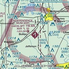
| Sectional chart |
|---|
|
| Airport distance calculator |
|---|
|
|
| Sunrise and sunset |
|---|
|
Times for 17-Jul-2026
| | Local
(UTC-5) | | Zulu
(UTC) |
|---|
| Morning civil twilight | | 05:47 | | 10:47 |
| Sunrise | | 06:17 | | 11:17 |
| Sunset | | 20:41 | | 01:41 |
| Evening civil twilight | | 21:11 | | 02:11 |
|
| Current date and time |
|---|
| Zulu (UTC) | 17-Jul-2026 11:14:01 |
|---|
| Local (UTC-5) | 17-Jul-2026 06:14:01 |
|---|
|
| METAR |
|---|
| KIDP | 171050Z AUTO 19007KT 10SM CLR 22/21 A3009 RMK AO2
|
KCFV
11nm SE | 171052Z AUTO 00000KT 10SM CLR 22/21 A3009 RMK AO2 SLP181 T02170206
|
KPPF
17nm NE | 171052Z AUTO 19005KT 10SM CLR 22/21 A3010 RMK AO2 SLP182 T02170206
|
|
| TAF |
|---|
KBVO
26nm SW | 170520Z 1706/1806 19003KT P6SM BKN150 FM171500 19008KT P6SM SCT045 BKN150 FM180200 19003KT P6SM BKN150
|
|
| NOTAMs |
|---|
NOTAMs are issued by the DoD/FAA and will open in a separate window not controlled by AirNav.
|
|

