FAA INFORMATION EFFECTIVE 27 NOVEMBER 2025
Location
| FAA Identifier: | BVO |
| Lat/Long: | 36-45-48.1000N 096-00-40.3000W
36-45.801667N 096-00.671667W
36.7633611,-96.0111944
(estimated) |
| Elevation: | 716.9 ft. / 218.5 m (surveyed) |
| Variation: | 03E (2020) |
| From city: | 2 miles NW of BARTLESVILLE, OK |
| Time zone: | UTC -6 (UTC -5 during Daylight Saving Time) |
| Zip code: | 74003 |
Airport Operations
| Airport use: | Open to the public |
| Activation date: | 11/1938 |
| Control tower: | no |
| ARTCC: | KANSAS CITY CENTER |
| FSS: | MC ALESTER FLIGHT SERVICE STATION |
| NOTAMs facility: | BVO (NOTAM-D service available) |
| Attendance: | MON-THU 0700-1900, ALL FRI-SUN 0700-1800 |
| Wind indicator: | lighted |
| Segmented circle: | yes |
| Lights: | ACTVT MALSR RWY 17; REIL RWY 35; PAPI RWY 17 & 35 - CTAF. MIRL RWY 17/35 OPER SS TO SR & PRESET LOW INTST, INCR INTST - CTAF. |
| Beacon: | white-green (lighted land airport)
Operates sunset to sunrise. |
Airport Communications
| CTAF: | 122.825 |
| WX ASOS: | 132.675 (918-336-2070) |
- APCH/DEP CTL SVC PRVDD BY KANSAS CITY ARTCC (ZKC) ON FREQS 128.6/282.325 (EDNA RCAG).
- NOTE: THIS FACILITY IS NOT AN ATCT FACILITY BUT AN ADVISORY COMMUNICATIONS STATION OPERATED BY THE AIRPORT.
- ADZY FREQ 122.825 MONITORED M-F DURG BUS HRS.
Nearby radio navigation aids
| VOR radial/distance | | VOR name | | Freq | | Var |
|---|
| BVOr167/4.3 | | BARTLESVILLE VOR/DME | | 117.90 | | 08E |
| TULr334/35.7 | | TULSA VORTAC | | 114.40 | | 08E |
Airport Services
| Fuel available: | 100LL JET-A+ |
| Oil available: | ADZY FREQ 122.825 MNT M-F DURG BUS HRS. |
| Parking: | hangars and tiedowns |
| Airframe service: | MAJOR |
| Powerplant service: | MAJOR |
| Bottled oxygen: | LOW |
| Bulk oxygen: | NONE |
Runway Information
Runway 17/35
| Dimensions: | 6850 x 100 ft. / 2088 x 30 m |
| Surface: | concrete/grooved, in good condition |
| Weight bearing capacity: | | Single wheel: | 50.0 | | Double wheel: | 100.0 | | Double tandem: | 170.0 |
|
| Runway edge lights: | medium intensity |
| RUNWAY 17 | | RUNWAY 35 |
| Latitude: | 36-46.365777N | | 36-45.237120N |
| Longitude: | 096-00.684808W | | 096-00.657128W |
| Elevation: | 685.5 ft. | | 716.9 ft. |
| Traffic pattern: | right | | left |
| Runway heading: | 176 magnetic, 179 true | | 356 magnetic, 359 true |
| Displaced threshold: | no | | 649 ft. |
| Declared distances: | TORA:6201 TODA:6201 ASDA:6201 LDA:6201 | | TORA:6850 TODA:6850 ASDA:6850 LDA:6201 |
| Markings: | precision, in good condition | | precision, in good condition |
| Visual slope indicator: | 4-light PAPI on left (3.00 degrees glide path) | | 4-light PAPI on left (3.00 degrees glide path) |
| Approach lights: | MALSR: 1,400 foot medium intensity approach lighting system with runway alignment indicator lights | | |
| Runway end identifier lights: | | | yes |
| Touchdown point: | yes, no lights | | yes, no lights |
| Instrument approach: | LOCALIZER | | |
| Obstructions: | 31 ft. trees, 572 ft. from runway, 344 ft. right of centerline, 12:1 slope to clear | | none |
Airport Ownership and Management from official FAA records
| Ownership: | Publicly-owned |
| Owner: | CITY OF BARTLESVILLE
CITY HALL, 401 S. JOHNSTONE
BARTLESVILLE, OK 74003
Phone 918-338-4282 |
| Manager: | MIKE RICHARDSON
401 NW WILEY POST RD.
BARTLESVILLE, OK 74003
Phone (918) 661-3500
FOR EMERG ONLY 918-350-0076. |
Additional Remarks
| - | FOR CD IF UNA TO CTC ON FSS FREQ, CTC KANSAS CITY ARTCC AT 913-254-8508. |
Instrument Procedures
NOTE: All procedures below are presented as PDF files. If you need a reader for these files, you should download the free Adobe Reader.NOT FOR NAVIGATION. Please procure official charts for flight.
FAA instrument procedures published for use from 27 November 2025 at 0901Z to 25 December 2025 at 0900Z.
IAPs - Instrument Approach Procedures |
|---|
| RNAV (GPS) RWY 17 | |
download (267KB) |
| RNAV (GPS) RWY 35 | |
download (248KB) |
| LOC RWY 17 | |
download (289KB) |
| VOR/DME RWY 35 | |
download (206KB) |
| NOTE: Special Alternate Minimums apply | |
download (39KB) |
| NOTE: Special Take-Off Minimums/Departure Procedures apply | |
download (460KB) |
Other nearby airports with instrument procedures:
KIDP - Independence Municipal Airport (26 nm NE)
KCFV - Coffeyville Municipal Airport (29 nm NE)
KTUL - Tulsa International Airport (34 nm S)
KOWP - William R Pogue Municipal Airport (36 nm S)
KGCM - Claremore Regional Airport (38 nm SE)
|
|

Road maps at:
MapQuest
Bing
Google
| Aerial photo |
|---|
WARNING: Photo may not be current or correct
 Photo by Toby Baker
Photo taken 07-Apr-2016
looking north.
Photo by Toby Baker
Photo taken 07-Apr-2016
looking north.
Do you have a better or more recent aerial photo of Bartlesville Municipal Airport that you would like to share? If so, please send us your photo.
|
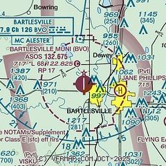
| Sectional chart |
|---|
|
| Airport distance calculator |
|---|
|
|
| Sunrise and sunset |
|---|
|
Times for 10-Dec-2025
| | Local
(UTC-6) | | Zulu
(UTC) |
|---|
| Morning civil twilight | | 06:58 | | 12:58 |
| Sunrise | | 07:27 | | 13:27 |
| Sunset | | 17:07 | | 23:07 |
| Evening civil twilight | | 17:36 | | 23:36 |
|
| Current date and time |
|---|
| Zulu (UTC) | 10-Dec-2025 19:30:57 |
|---|
| Local (UTC-6) | 10-Dec-2025 13:30:57 |
|---|
|
| METAR |
|---|
| KBVO | 101853Z AUTO 33007KT 280V020 10SM CLR 13/M03 A3013 RMK AO2 SLP199 T01281033
|
|
| TAF |
|---|
| KBVO | 101721Z 1018/1118 34013G22KT P6SM SKC FM102300 32005KT P6SM SKC FM111700 22010KT P6SM SKC
|
|
| NOTAMs |
|---|
NOTAMs are issued by the DoD/FAA and will open in a separate window not controlled by AirNav.
|
|


