FAA INFORMATION EFFECTIVE 11 JUNE 2026
Location
| FAA Identifier: | JZI |
| Lat/Long: | 32-42-03.7000N 080-00-11.7000W
32-42.061667N 080-00.195000W
32.7010278,-80.0032500
(estimated) |
| Elevation: | 18.6 ft. / 5.7 m (surveyed) |
| Variation: | 05W (1985) |
| From city: | 6 miles SW of CHARLESTON, SC |
| Time zone: | UTC -4 (UTC -5 during Standard Time) |
| Zip code: | 29455 |
Airport Operations
| Airport use: | Open to the public |
| Activation date: | 04/1943 |
| Control tower: | no |
| ARTCC: | JACKSONVILLE CENTER |
| FSS: | ANDERSON FLIGHT SERVICE STATION |
| NOTAMs facility: | AND (NOTAM-D service available) |
| Attendance: | 0600-2200 |
| Wind indicator: | lighted, SUPPLEMENTARY LGTD WINDCONES RWYS 04, 22, 09 & 27. |
| Segmented circle: | yes |
| Lights: | SR-SS, TO ACTVT AND INCR INTST REIL RWY 09 & 27; HIRL RWY 09/27; MIRL RWY 04/22 - CTAF. SR-SS, PAPI RWY 09 & 27 OPR CONSLY. SS-SR, REIL RWY 09 & 27; PAPI RWY 09 & 27; HIRL RWY 09/27 OPR CONSLY, TO INCR INTST - CTAF. SS-SR, TO ACTVT MIRL RWY 04/22 - CTAF. |
| Beacon: | white-green (lighted land airport)
Operates sunset to sunrise. |
Airport Communications
| CTAF/UNICOM: | 122.8 |
| WX AWOS-3: | 123.775 (843-559-3123) |
| CHARLESTON APPROACH: | 120.7 [1200-0400Z++ MON-SUN; 1500-2300Z++ HOLS.] |
| CHARLESTON DEPARTURE: | 120.7 [1200-0400Z++ MON-SUN; 1500-2300Z++ HOLS.] |
| CLEARANCE DELIVERY: | 119.85 |
| WX AWOS-1 at SC80 (6 nm NE): | 122.975 (843-985-0983) |
| WX ASOS at CHS (12 nm N): | PHONE 843-214-2525 |
| WX AWOS-3 at LRO (16 nm NE): | 118.625 (843-849-0438) |
Nearby radio navigation aids
| VOR radial/distance | | VOR name | | Freq | | Var |
|---|
| CHSr176/11.7 | | CHARLESTON VORTAC | | 113.50 | | 05W |
Airport Services
| Fuel available: | 100LL JET-A |
| Parking: | hangars and tiedowns |
| Airframe service: | MINOR |
| Powerplant service: | MINOR |
| Bulk oxygen: | NONE |
Runway Information
Runway 9/27
| Dimensions: | 5350 x 100 ft. / 1631 x 30 m |
| Surface: | concrete/grooved, in excellent condition |
| Weight bearing capacity: | | Single wheel: | 60.0 | | Double wheel: | 100.0 |
|
| Runway edge lights: | high intensity |
| RUNWAY 9 | | RUNWAY 27 |
| Latitude: | 32-42.291312N | | 32-42.302897N |
| Longitude: | 080-00.773787W | | 079-59.730383W |
| Elevation: | 18.6 ft. | | 11.1 ft. |
| Traffic pattern: | left | | left |
| Runway heading: | 094 magnetic, 089 true | | 274 magnetic, 269 true |
| Displaced threshold: | no | | 350 ft. |
| Markings: | precision, in good condition | | nonprecision, in good condition |
| Visual slope indicator: | 4-light PAPI on left (3.00 degrees glide path) | | 4-light PAPI on right (3.00 degrees glide path) |
| Runway end identifier lights: | yes | | yes |
| Touchdown point: | yes, no lights | | yes, no lights |
| Instrument approach: | ILS/DME | | |
| Obstructions: | 110 ft. trees, 3589 ft. from runway, 781 ft. left of centerline, 30:1 slope to clear | | 16 ft. brush, 438 ft. from runway, 250 ft. right of centerline, 14:1 slope to clear
APPROACH SLOPE TO DISPLACED THR. IS 50:1. |
Runway 4/22
| Dimensions: | 4313 x 150 ft. / 1315 x 46 m |
| Surface: | concrete, in good condition |
| Weight bearing capacity: | | Single wheel: | 45.0 | | Double wheel: | 56.0 |
|
| Runway edge lights: | medium intensity |
| RUNWAY 4 | | RUNWAY 22 |
| Latitude: | 32-41.467087N | | 32-42.068903N |
| Longitude: | 080-00.349825W | | 079-59.901578W |
| Elevation: | 9.8 ft. | | 11.1 ft. |
| Traffic pattern: | left | | left |
| Runway heading: | 037 magnetic, 032 true | | 217 magnetic, 212 true |
| Markings: | nonprecision, in good condition | | basic, in good condition |
| Touchdown point: | yes, no lights | | yes, no lights |
| Obstructions: | 83 ft. tree, 2221 ft. from runway, 50 ft. right of centerline, 24:1 slope to clear
TREE LINE 231 FEET EAST OF RWY 4 THLD 21 FEET HIGH | | none |
Airport Ownership and Management from official FAA records
| Ownership: | Publicly-owned |
| Owner: | CHARLESTON CO AVN AUTHORITY
5500 INTL BLVD, # 101
CHARLESTON, SC 29418-6911
Phone 843-767-7000 |
| Manager: | ELLIOTT SUMMEY
5500 INTERNATIONAL BLVD, #101
CHARLESTON, SC 29418
Phone 843-767-7000 |
Additional Remarks
| - | DEER & BIRDS ON & INVOF ARPT. |
| - | FOR CD CTC CHARLESTON APCH AT 843-414-2832. |
Instrument Procedures
NOTE: All procedures below are presented as PDF files. If you need a reader for these files, you should download the free Adobe Reader.NOT FOR NAVIGATION. Please procure official charts for flight.
FAA instrument procedures published for use from 11 June 2026 at 0901Z to 09 July 2026 at 0900z.
STARs - Standard Terminal Arrivals |
|---|
| AMYLU THREE (RNAV) **NEW** | |
2 pages:
[1] [2] (368KB) |
| BAGGY THREE (RNAV) **NEW** | |
2 pages:
[1] [2] (398KB) |
| OSPRI SEVEN (RNAV) **NEW** | |
2 pages:
[1] [2] (532KB) |
IAPs - Instrument Approach Procedures |
|---|
| ILS OR LOC RWY 09 | |
download (398KB) |
| RNAV (GPS) RWY 04 | |
download (254KB) |
| RNAV (GPS) RWY 09 | |
download (333KB) |
| RNAV (GPS) RWY 27 | |
download (307KB) |
| NOTE: Special Alternate Minimums apply | |
download (166KB) |
Departure Procedures |
|---|
| EXECUTIVE ONE (RNAV) | |
download (273KB) |
| KIAWAH TWO (RNAV) | |
download (169KB) |
| NOTE: Special Take-Off Minimums/Departure Procedures apply | |
download (355KB) |
Other nearby airports with instrument procedures:
KCHS - Charleston Air Force Base/International Airport (12 nm N)
KLRO - Mount Pleasant Regional Airport-Faison Field (16 nm NE)
KDYB - Summerville Airport (26 nm NW)
KMKS - Berkeley County Airport (29 nm N)
KRBW - Lowcountry Regional Airport (35 nm NW)
|
|

Road maps at:
MapQuest
Bing
Google
| Aerial photo |
|---|
WARNING: Photo may not be current or correct
 Photo courtesy of CCAA (Charleston County Aviation Authority)
Taken in October 2017
looking southwest.
Photo courtesy of CCAA (Charleston County Aviation Authority)
Taken in October 2017
looking southwest.
Do you have a better or more recent aerial photo of Charleston Executive Airport that you would like to share? If so, please send us your photo.
|
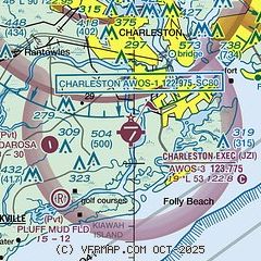
| Sectional chart |
|---|
|
| Airport distance calculator |
|---|
|
|
| Sunrise and sunset |
|---|
|
Times for 17-Jun-2026
| | Local
(UTC-4) | | Zulu
(UTC) |
|---|
| Morning civil twilight | | 05:44 | | 09:44 |
| Sunrise | | 06:13 | | 10:13 |
| Sunset | | 20:29 | | 00:29 |
| Evening civil twilight | | 20:57 | | 00:57 |
|
| Current date and time |
|---|
| Zulu (UTC) | 17-Jun-2026 04:55:42 |
|---|
| Local (UTC-4) | 17-Jun-2026 00:55:42 |
|---|
|
| METAR |
|---|
| KJZI | 170435Z AUTO 22004KT 9SM -DZ FEW034 SCT050 BKN075 23/23 A2991 RMK AO2
|
KCHS
12nm N | 170356Z 23004KT 10SM FEW055 SCT110 BKN160 23/22 A2991 RMK AO2 RAB07E24 SLP127 P0000 T02280217
|
KLRO
16nm NE | 170435Z AUTO 00000KT 10SM SCT120 24/24 A2991 RMK AO2
|
|
| TAF |
|---|
| KJZI | 170412Z 1704/1724 24006KT P6SM -RA SCT030 BKN050 FM170900 23007KT 6SM -SHRA BKN020 OVC030 FM171500 24012G18KT P6SM SCT025 BKN035 FM172300 21010KT P6SM BKN035
|
KCHS
12nm N | 170411Z 1704/1724 21005KT P6SM -RA SCT030 BKN050 FM171000 23007KT 6SM -SHRA BKN020 OVC030 FM171500 24011G17KT P6SM SCT025 BKN035
|
|
| NOTAMs |
|---|
NOTAMs are issued by the DoD/FAA and will open in a separate window not controlled by AirNav.
|
|


