FAA INFORMATION EFFECTIVE 30 OCTOBER 2025
Location
| FAA Identifier: | K23 |
| Lat/Long: | 42-37-45.2730N 074-53-27.5560W
42-37.754550N 074-53.459267W
42.6292425,-74.8909878
(estimated) |
| Elevation: | 1260 ft. / 384 m (estimated) |
| Variation: | 13W (1985) |
| From city: | 4 miles SE of COOPERSTOWN, NY |
| Time zone: | UTC -5 (UTC -4 during Daylight Saving Time) |
| Zip code: | 13326 |
Airport Operations
| Airport use: | Open to the public |
| Activation date: | 05/1956 |
| Control tower: | no |
| ARTCC: | BOSTON CENTER |
| FSS: | BUFFALO FLIGHT SERVICE STATION |
| NOTAMs facility: | BUF (NOTAM-D service available) |
| Attendance: | UNATNDD
CALL MGR FOR SERVICES. |
| Wind indicator: | yes |
| Segmented circle: | yes |
| Lights: | ACTVT MIRL RY 02/20 - CTAF. |
Airport Communications
| CTAF/UNICOM: | 122.8 |
| WX AWOS-3 at N66 (10 nm SW): | 119.575 (607-643-0253) |
Nearby radio navigation aids
| VOR radial/distance | | VOR name | | Freq | | Var |
|---|
| RKAr069/18.2 | | ROCKDALE VOR/DME | | 112.60 | | 11W |
| DNYr017/27.2 | | DELANCEY VOR/DME | | 112.10 | | 11W |
| HNKr040/38.9 | | HANCOCK VOR/DME | | 116.80 | | 11W |
| NDB name | | Hdg/Dist | | Freq | | Var | | ID |
|---|
| JOHNSTOWN | | 242/33.2 | | 523 | | 14W | | JJH | .--- .--- .... |
Airport Services
| Fuel available: | 100LL
100LL:ATNDD ONLY. |
| Parking: | hangars and tiedowns |
| Airframe service: | MAJOR |
| Powerplant service: | MAJOR |
| Bottled oxygen: | NONE |
| Bulk oxygen: | NONE |
Runway Information
Runway 2/20
| Dimensions: | 2337 x 125 ft. / 712 x 38 m
RWY EDGE MKD BY YELLOW TIRES ARND EDGE LGTS. |
| Surface: | turf, in fair condition |
| Runway edge lights: | non-standard
NSTD MIRL; SPACING; 2 THLD LGTS EACH SIDE. |
| RUNWAY 2 | | RUNWAY 20 |
| Traffic pattern: | right | | left |
| Visual slope indicator: | non-standard VASI system | | non-standard VASI system |
| Obstructions: | 33 ft. trees, 46 ft. from runway, 80 ft. right of centerline, 1:1 slope to clear
RWY 02; +60 FT TREE, 359 FT FROM THRESHOLD, 145 FT LEFT | | 9 ft. crops, 51 ft. from runway, 1 ft. both sides of centerline
RWY 20; +37 FT POLE, 394 FT FROM THRESHOLD, 163 FT RIGHT |
Airport Ownership and Management from official FAA records
| Ownership: | Privately-owned |
| Owner: | RICK WILLIAMS
866 ST. RT. 166, PO BOX 52, PO BOX 1285
COOPERSTOWN, NY 13326-8661
Phone (607) 437-8308 |
| Manager: | RICK WILLIAMS
BODEE AVIATION, LLC, PO BOX 52
COOPERSTOWN, NY 13326
Phone 607-437-8308 |
Additional Remarks
| - | FOR CD CTC BOSTON ARTCC AT 603-879-6859. |
Instrument Procedures
There are no published instrument procedures at K23.
Some nearby airports with instrument procedures:
N66 - Albert S Nader Regional Airport (10 nm SW)
KOIC - LT Warren Eaton Airport (28 nm W)
N23 - Sidney Municipal Airport (30 nm SW)
KVGC - Hamilton Municipal Airport (32 nm NW)
NY0 - Fulton County Airport (33 nm NE)
|
|

Road maps at:
MapQuest
Bing
Google
| Aerial photo |
|---|
WARNING: Photo may not be current or correct
 Photo by Michael Kilcher
As seen circa 2007
looking south.
Photo by Michael Kilcher
As seen circa 2007
looking south.
Do you have a better or more recent aerial photo of Cooperstown-Westville Airport that you would like to share? If so, please send us your photo.
|
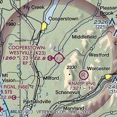
| Sectional chart |
|---|
|
| Airport distance calculator |
|---|
|
|
| Sunrise and sunset |
|---|
|
Times for 21-Nov-2025
| | Local
(UTC-5) | | Zulu
(UTC) |
|---|
| Morning civil twilight | | 06:29 | | 11:29 |
| Sunrise | | 06:59 | | 11:59 |
| Sunset | | 16:32 | | 21:32 |
| Evening civil twilight | | 17:02 | | 22:02 |
|
| Current date and time |
|---|
| Zulu (UTC) | 21-Nov-2025 12:50:36 |
|---|
| Local (UTC-5) | 21-Nov-2025 07:50:36 |
|---|
|
| METAR |
|---|
KOIC
28nm W | 211235Z AUTO 14003KT 10SM OVC025 03/01 A3001 RMK AO2
|
KVGC
32nm NW | 211235Z AUTO 14006KT 10SM OVC026 02/00 A2999 RMK AO2
|
KNY0
33nm NE | 211235Z AUTO 07003KT 10SM OVC017 M02/M03 A3002 RMK AO2 T10181032
|
KRME
42nm NW | 211153Z 13003KT 10SM OVC036 01/M03 A3002 RMK AO2 SLP169 T00061028 10006 21033 55008
|
KSCH
45nm E | 210259Z 00000KT 10SM CLR M03/M07 A3016
|
KALB
49nm E | 211240Z 14005KT 10SM OVC029 01/M03 A3004 RMK T00111033
|
|
| TAF |
|---|
KRME
42nm NW | 211130Z 2112/2212 VRB03KT P6SM BKN035 FM211430 15004KT P6SM BKN018 FM212300 26004KT P6SM BKN035 FM220300 29004KT P6SM BKN035
|
KALB
49nm E | 211120Z 2112/2212 17003KT P6SM OVC035 TEMPO 2112/2115 OVC030 FM211500 17007KT P6SM BKN035 FM220000 26005KT P6SM BKN040
|
|
| NOTAMs |
|---|
NOTAMs are issued by the DoD/FAA and will open in a separate window not controlled by AirNav.
|
|

