FAA INFORMATION EFFECTIVE 14 MAY 2026
Location
| FAA Identifier: | AFK |
| Lat/Long: | 40-36-23.5000N 095-52-00.0000W
40-36.391667N 095-52.000000W
40.6065278,-95.8666667
(estimated) |
| Elevation: | 1165 ft. / 355.1 m (surveyed) |
| Variation: | 05E (1995) |
| From city: | 4 miles S of NEBRASKA CITY, NE |
| Time zone: | UTC -5 (UTC -6 during Standard Time) |
| Zip code: | 68410 |
Airport Operations
| Airport use: | Open to the public |
| Control tower: | no |
| ARTCC: | MINNEAPOLIS CENTER |
| FSS: | COLUMBUS FLIGHT SERVICE STATION |
| NOTAMs facility: | AFK (NOTAM-D service available) |
| Attendance: | MON-FRI 0800-1700, ALL SAT-SUN 0900-1700 |
| Wind indicator: | lighted |
| Segmented circle: | yes |
| Lights: | ACTVT MIRL RY 15/33 & PAPI RYS 15 & 33 - CTAF. |
| Beacon: | white-green (lighted land airport)
Operates sunset to sunrise. |
Airport Communications
| CTAF/UNICOM: | 122.7 |
| WX AWOS-3PT: | 128.325 (402-873-7375) |
| OMAHA APPROACH: | 135.875 |
| OMAHA DEPARTURE: | 135.875 |
Nearby radio navigation aids
| VOR radial/distance | | VOR name | | Freq | | Var |
|---|
| OVRr182/34.1 | | OMAHA VORTAC | | 116.30 | | 08E |
| NDB name | | Hdg/Dist | | Freq | | Var | | ID |
|---|
| PLATTSMOUTH | | 169/20.3 | | 329 | | 05E | | PMV | .--. -- ...- |
Airport Services
| Fuel available: | 100LL JET-A
100LL:FOR FUEL CALL 402-873-0550; IF NO ANS CALL AMGR AT 402-209-1012. |
| Parking: | hangars and tiedowns |
Runway Information
Runway 15/33
| Dimensions: | 4501 x 76 ft. / 1372 x 23 m |
| Surface: | concrete, in good condition |
| Weight bearing capacity: | |
| Runway edge lights: | medium intensity |
| RUNWAY 15 | | RUNWAY 33 |
| Latitude: | 40-36.738943N | | 40-36.087695N |
| Longitude: | 095-52.174037W | | 095-51.709712W |
| Elevation: | 1156.7 ft. | | 1157.6 ft. |
| Traffic pattern: | left | | left |
| Runway heading: | 146 magnetic, 151 true | | 326 magnetic, 331 true |
| Markings: | nonprecision, in good condition | | nonprecision, in good condition |
| Visual slope indicator: | 2-light PAPI on left (3.00 degrees glide path) | | 2-light PAPI on left (3.00 degrees glide path) |
| Touchdown point: | yes, no lights | | yes, no lights |
Runway 5/23
| Dimensions: | 2550 x 151 ft. / 777 x 46 m |
| Surface: | turf, in good condition |
| RUNWAY 5 | | RUNWAY 23 |
| Latitude: | 40-36.210833N | | 40-36.496333N |
| Longitude: | 095-52.304667W | | 095-51.900500W |
| Elevation: | 1164.8 ft. | | 1159.9 ft. |
| Traffic pattern: | left | | left |
| Runway heading: | 043 magnetic, 048 true | | 223 magnetic, 228 true |
| Touchdown point: | yes, no lights | | yes, no lights |
Airport Ownership and Management from official FAA records
| Ownership: | Publicly-owned |
| Owner: | CITY OF NEBRASKA CITY
1409 CENTRAL AVE
NEBRASKA CITY, NE 68410-2223
Phone (402) 873-5515
PERRY MADER, CITY ADMIR (402) 873-5515. |
| Manager: | KYLE GRESS
972 S. 64TH ROAD
NEBRASKA CITY, NE 68410-6805
Phone 402-873-0550 |
Additional Remarks
| - | FOR SVC AND INFO CALL 402-873-0550. |
| - | FOR CD CTC OMAHA APCH AT 402-682-4395. |
Instrument Procedures
NOTE: All procedures below are presented as PDF files. If you need a reader for these files, you should download the free Adobe Reader.NOT FOR NAVIGATION. Please procure official charts for flight.
FAA instrument procedures published for use from 14 May 2026 at 0901Z to 11 June 2026 at 0900Z.
IAPs - Instrument Approach Procedures |
|---|
| RNAV (GPS) RWY 15 **CHANGED** | |
download (213KB) |
| RNAV (GPS) RWY 33 **CHANGED** | |
download (211KB) |
| NOTE: Special Alternate Minimums apply | |
download (147KB) |
| NOTE: Special Take-Off Minimums/Departure Procedures apply | |
download (147KB) |
Other nearby airports with instrument procedures:
K01 - Farington Field Airport (14 nm S)
0G3 - Tecumseh Municipal Airport (19 nm SW)
KPMV - Plattsmouth Municipal Airport/Douglas V Duey Field (21 nm N)
KSDA - Shenandoah Municipal Airport (22 nm NE)
K57 - Gould Peterson Municipal Airport (25 nm SE)
|
|

Road maps at:
MapQuest
Bing
Google
| Aerial photo |
|---|
WARNING: Photo may not be current or correct
 Photo by William Maxey
Photo taken 16-Nov-2007
Photo by William Maxey
Photo taken 16-Nov-2007
Do you have a better or more recent aerial photo of Nebraska City Municipal Airport that you would like to share? If so, please send us your photo.
|
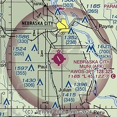
| Sectional chart |
|---|
|
| Airport distance calculator |
|---|
|
|
| Sunrise and sunset |
|---|
|
Times for 09-Jun-2026
| | Local
(UTC-5) | | Zulu
(UTC) |
|---|
| Morning civil twilight | | 05:20 | | 10:20 |
| Sunrise | | 05:53 | | 10:53 |
| Sunset | | 20:52 | | 01:52 |
| Evening civil twilight | | 21:25 | | 02:25 |
|
| Current date and time |
|---|
| Zulu (UTC) | 09-Jun-2026 22:33:11 |
|---|
| Local (UTC-5) | 09-Jun-2026 17:33:11 |
|---|
|
| METAR |
|---|
| KAFK | 092215Z AUTO 19014G21KT 10SM BKN037 OVC043 31/23 A2977 RMK AO2 T03060230
|
|
| TAF |
|---|
KOFF
31nm N | 092015Z 0920/1024 15010G15KT 9999 SCT040 QNH2970INS TEMPO 0920/0924 15015G25KT BECMG 1001/1002 15010G15KT 8000 -SHRA SCT030 BKN040 QNH2963INS TEMPO 1003/1006 VRB30G50KT 4800 -TSRAGR OVC020CB BECMG 1009/1010 20012G18KT 9999 NSW BKN030 BKN200 QNH2962INS TEMPO 1018/1021 VRB25G40KT 4800 -TSRAGR OVC020CB TX32/0920Z TN24/1012Z
|
|
| NOTAMs |
|---|
NOTAMs are issued by the DoD/FAA and will open in a separate window not controlled by AirNav.
|
|


