FAA INFORMATION EFFECTIVE 09 JULY 2026
Location
| FAA Identifier: | SDA |
| Lat/Long: | 40-45-05.7140N 095-24-49.0470W
40-45.095233N 095-24.817450W
40.7515872,-95.4136242
(estimated) |
| Elevation: | 971.1 ft. / 296.0 m (surveyed) |
| Variation: | 05E (1995) |
| From city: | 3 miles SW of SHENANDOAH, IA |
| Time zone: | UTC -5 (UTC -6 during Standard Time) |
| Zip code: | 51601 |
Airport Operations
| Airport use: | Open to the public |
| Activation date: | 04/1946 |
| Control tower: | no |
| ARTCC: | MINNEAPOLIS CENTER |
| FSS: | FORT DODGE FLIGHT SERVICE STATION |
| NOTAMs facility: | SDA (NOTAM-D service available) |
| Attendance: | MON - SAT 0800-1700
FOR ATTENDANT AFT HRS CALL (712) 370-2367. |
| Wind indicator: | lighted |
| Segmented circle: | yes |
| Lights: | ACTVT MIRL RY 04/22; PAPI RYS 04 & 22; VASI RY 30; REIL RYS 04 & 22 - CTAF. |
| Beacon: | white-green (lighted land airport)
Operates sunset to sunrise. |
Airport Communications
| CTAF/UNICOM: | 122.8 |
| WX AWOS-3: | 125.525 (712-246-4021) |
| OMAHA APPROACH: | 124.5 |
| OMAHA DEPARTURE: | 124.5 |
| WX AWOS-3P at RDK (17 nm NE): | 123.925 (712-623-3220) |
| WX AWOS-3 at ICL (18 nm E): | 132.025 (712-542-3345) |
Nearby radio navigation aids
| VOR radial/distance | | VOR name | | Freq | | Var |
|---|
| OVRr142/28.9 | | OMAHA VORTAC | | 116.30 | | 08E |
| NDB name | | Hdg/Dist | | Freq | | Var | | ID |
|---|
| PLATTSMOUTH | | 112/25.4 | | 329 | | 05E | | PMV | .--. -- ...- |
Airport Services
| Fuel available: | 100LL JET-A+ |
| Parking: | hangars and tiedowns |
| Airframe service: | MAJOR |
| Powerplant service: | MAJOR |
| Bottled oxygen: | NONE |
| Bulk oxygen: | NONE |
Runway Information
Runway 4/22
| Dimensions: | 5000 x 75 ft. / 1524 x 23 m |
| Surface: | concrete, in good condition |
| Weight bearing capacity: | | PCN 10 /R/C/W/T | | Single wheel: | 30.0 | | Double wheel: | 38.0 |
|
| Runway edge lights: | medium intensity |
| RUNWAY 4 | | RUNWAY 22 |
| Latitude: | 40-44.726680N | | 40-45.326228N |
| Longitude: | 095-25.106890W | | 095-24.364673W |
| Elevation: | 960.7 ft. | | 967.9 ft. |
| Traffic pattern: | left | | left |
| Runway heading: | 038 magnetic, 043 true | | 218 magnetic, 223 true |
| Markings: | nonprecision, in fair condition | | nonprecision, in fair condition |
| Visual slope indicator: | 2-light PAPI on left (3.00 degrees glide path) | | 2-light PAPI on left (3.00 degrees glide path) |
| Runway end identifier lights: | yes | | yes |
| Touchdown point: | yes, no lights | | yes, no lights |
| Obstructions: | 15 ft. brush, 225 ft. from runway, 163 ft. left of centerline, 1:1 slope to clear
24 FT TREE 30 FT FM RWY END 168 FT RIGHT ON APCH 1:1 APCH SLP. | | 10 ft. brush, marked and lighted, 210 ft. from runway, 160 ft. right of centerline, 1:1 slope to clear
10 FT TREE 10 FT FM RWY END 175 FT RIGHT ON APCH 1:1 APCH SLP. |
Runway 12/30
| Dimensions: | 3439 x 75 ft. / 1048 x 23 m |
| Surface: | concrete, in good condition |
| Weight bearing capacity: | | PCN 6 /R/C/W/T | | Single wheel: | 4.0 |
|
| Runway edge lights: | low intensity |
| RUNWAY 12 | | RUNWAY 30 |
| Latitude: | 40-45.357945N | | 40-45.032500N |
| Longitude: | 095-25.240888W | | 095-24.631500W |
| Elevation: | 952.2 ft. | | 969.4 ft. |
| Traffic pattern: | left | | left |
| Runway heading: | 120 magnetic, 125 true | | 300 magnetic, 305 true |
| Markings: | nonprecision, in good condition | | nonprecision, in good condition |
| Visual slope indicator: | | | 4-box VASI on left (3.50 degrees glide path) |
| Runway end identifier lights: | | | no |
| Touchdown point: | yes, no lights | | yes, no lights |
| Obstructions: | 23 ft. trees, 568 ft. from runway, 138 ft. left of centerline, 16:1 slope to clear
ACCESS ROAD 40 FT FM RWY END ON RWY CENTERLINE 1:1. | | 23 ft. trees, 262 ft. from runway, 113 ft. left of centerline, 2:1 slope to clear |
Airport Ownership and Management from official FAA records
| Ownership: | Publicly-owned |
| Owner: | CITY OF SHENANDOAH
500 WEST CLARINDA
SHENANDOAH, IA 51601
Phone 712-246-4411
AJ LYMAN- CITY MGR PHONE 712-246-4411. |
| Manager: | RANDY WAGNER
2033 MANTI ROAD
SHENANDOAH, IA 51601
Phone 712-246-1931 |
Additional Remarks
| - | RY 22 IS CALM WIND RY. |
| - | FOR CD CTC OMAHA APCH AT 402-682-4395. |
Instrument Procedures
NOTE: All procedures below are presented as PDF files. If you need a reader for these files, you should download the free Adobe Reader.NOT FOR NAVIGATION. Please procure official charts for flight.
FAA instrument procedures published for use from 09 July 2026 at 0901Z to 06 August 2026 at 0900Z.
IAPs - Instrument Approach Procedures |
|---|
| RNAV (GPS) RWY 04 | |
download (233KB) |
| VOR/DME RWY 12 | |
download (191KB) |
| NOTE: Special Alternate Minimums apply | |
download (110KB) |
| NOTE: Special Take-Off Minimums/Departure Procedures apply | |
download (158KB) |
Other nearby airports with instrument procedures:
KRDK - Red Oak Municipal Airport (17 nm NE)
KICL - Schenck Field Airport (18 nm E)
K57 - Gould Peterson Municipal Airport (18 nm S)
KAFK - Nebraska City Municipal Airport (22 nm SW)
KPMV - Plattsmouth Municipal Airport/Douglas V Duey Field (26 nm NW)
|
|

Road maps at:
MapQuest
Bing
Google
| Aerial photo |
|---|
WARNING: Photo may not be current or correct
 Photo by William Maxey
Photo taken 07-Nov-2003
Photo by William Maxey
Photo taken 07-Nov-2003
Do you have a better or more recent aerial photo of Shenandoah Municipal Airport that you would like to share? If so, please send us your photo.
|
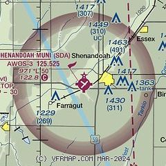
| Sectional chart |
|---|
|
| Airport distance calculator |
|---|
|
|
| Sunrise and sunset |
|---|
|
Times for 24-Jul-2026
| | Local
(UTC-5) | | Zulu
(UTC) |
|---|
| Morning civil twilight | | 05:40 | | 10:40 |
| Sunrise | | 06:12 | | 11:12 |
| Sunset | | 20:44 | | 01:44 |
| Evening civil twilight | | 21:16 | | 02:16 |
|
| Current date and time |
|---|
| Zulu (UTC) | 24-Jul-2026 11:20:09 |
|---|
| Local (UTC-5) | 24-Jul-2026 06:20:09 |
|---|
|
| METAR |
|---|
| KSDA | 241055Z AUTO 09005KT 10SM BKN033 BKN043 OVC050 20/20 A3002 RMK AO2
|
KRDK
17nm NE | 241055Z AUTO 10006KT 10SM FEW035 OVC070 19/18 A3005 RMK AO2
|
KICL
18nm E | 241055Z AUTO 00000KT 10SM BKN039 OVC065 A3007 RMK AO2
|
|
| TAF |
|---|
KOFF
32nm NW | 241000Z 2410/2516 12006KT 9000 -SHRA BKN025 OVC080 QNH3003INS TEMPO 2412/2414 BKN015 BECMG 2413/2414 14009KT 9000 -SHRA OVC015 QNH3003INS TEMPO 2414/2416 OVC009 BECMG 2415/2416 14009KT 9999 NSW OVC015 QNH3000INS TEMPO 2416/2418 OVC009 BECMG 2419/2420 15012KT 9999 BKN025 QNH2996INS BECMG 2423/2424 14009KT 9999 SCT025 QNH2996INS BECMG 2505/2506 14006KT 4800 BR OVC005 QNH2996INS BECMG 2513/2514 16006KT 9999 NSW BKN035 BKN120 QNH2997INS TX27/2422Z TN19/2412Z
|
|
| NOTAMs |
|---|
NOTAMs are issued by the DoD/FAA and will open in a separate window not controlled by AirNav.
|
|

