FAA INFORMATION EFFECTIVE 22 JANUARY 2026
Location
| FAA Identifier: | AXV |
| Lat/Long: | 40-29-36.7730N 084-17-53.0680W
40-29.612883N 084-17.884467W
40.4935481,-84.2980744
(estimated) |
| Elevation: | 912.3 ft. / 278.1 m (surveyed) |
| Variation: | 04W (1985) |
| From city: | 8 miles SW of WAPAKONETA, OH |
| Time zone: | UTC -5 (UTC -4 during Daylight Saving Time) |
| Zip code: | 45871 |
Airport Operations
| Airport use: | Open to the public |
| Activation date: | 05/1956 |
| Control tower: | no |
| ARTCC: | INDIANAPOLIS CENTER |
| FSS: | DAYTON FLIGHT SERVICE STATION |
| NOTAMs facility: | AXV (NOTAM-D service available) |
| Attendance: | MON-FRI 0700-1700, ALL SAT-SUN ON CALL
FOR SVC & FUEL CALL AMGR. |
| Pattern altitude: | 1902.3 ft. MSL |
| Wind indicator: | lighted |
| Segmented circle: | no |
| Lights: | ACTVT REIL RWY 08 & 26; MIRL RWY 08/26 - 122.7. |
| Beacon: | white-green (lighted land airport)
Operates sunset to sunrise. |
Airport Communications
| CTAF/UNICOM: | 122.8 |
| WX AWOS-3PT: | 128.325 (419-753-2821) |
| COLUMBUS APPROACH: | 134.45 |
| COLUMBUS DEPARTURE: | 134.45 |
| WX AWOS-3 at SCA (17 nm SE): | 120.425 (937-492-3683) |
| WX ASOS at AOH (18 nm NE): | 128.725 (419-224-6098) |
Nearby radio navigation aids
| VOR radial/distance | | VOR name | | Freq | | Var |
|---|
| RODr322/17.0 | | ROSEWOOD VORTAC | | 117.50 | | 05W |
| DQNr010/29.0 | | DAYTON VOR/DME | | 114.50 | | 01W |
| FBCr224/37.1 | | FLAG CITY VORTAC | | 108.20 | | 02W |
Airport Services
| Fuel available: | 100LL JET-A1+
100LL:100LL & JET A1+ AVBL H24 SELF SVC VIA CREDIT CARD. |
| Parking: | tiedowns |
| Airframe service: | MAJOR |
| Powerplant service: | MAJOR |
| Bottled oxygen: | HIGH |
| Bulk oxygen: | NONE |
Runway Information
Runway 8/26
| Dimensions: | 5500 x 100 ft. / 1676 x 30 m |
| Surface: | asphalt/grooved, in fair condition |
| Runway edge lights: | medium intensity |
| RUNWAY 8 | | RUNWAY 26 |
| Latitude: | 40-29.507773N | | 40-29.717953N |
| Longitude: | 084-18.461433W | | 084-17.307480W |
| Elevation: | 907.7 ft. | | 908.0 ft. |
| Traffic pattern: | left | | left |
| Runway heading: | 081 magnetic, 077 true | | 261 magnetic, 257 true |
| Displaced threshold: | 698 ft. | | 237 ft. |
| Markings: | nonprecision, in fair condition | | nonprecision, in fair condition |
| Visual slope indicator: | 4-light PAPI on left (4.00 degrees glide path) | | 4-light PAPI on left (3.00 degrees glide path) |
| Runway end identifier lights: | yes | | yes |
| Touchdown point: | yes, no lights | | yes, no lights |
| Instrument approach: | | | LOC/DME |
| Obstructions: | 89 ft. trees, 485 ft. from runway, 238 ft. left of centerline, 3:1 slope to clear
APCH SLP 13:1 TO DTHR DUE TO +89 FT TREE, 1168 FT DIST, 238 FT L. | | 15 ft. road, lighted, 330 ft. from runway, 275 ft. right of centerline, 8:1 slope to clear
8 FT FENCE, 65-200 FT DIST, 220-230 FT L. |
Airport Ownership and Management from official FAA records
| Ownership: | Publicly-owned |
| Owner: | AUGLAIZE CO ARPT AUTH
PO BOX 400
NEW KNOXVILLE, OH 45871-0400
Phone 419-753-2810 |
| Manager: | TED BERGSTROM
PO BOX 400
NEW KNOXVILLE, OH 45871-0400
Phone 419-753-2810 |
Additional Remarks
| - | FOR CD CTC COLUMBUS APCH AT 614-338-8537. |
| - | WILDLIFE ON & INVOF ARPT. |
Instrument Procedures
NOTE: All procedures below are presented as PDF files. If you need a reader for these files, you should download the free Adobe Reader.NOT FOR NAVIGATION. Please procure official charts for flight.
FAA instrument procedures published for use from 22 January 2026 at 0901Z to 19 February 2026 at 0900z.
IAPs - Instrument Approach Procedures |
|---|
| RNAV (GPS) RWY 08 | |
download (210KB) |
| RNAV (GPS) RWY 26 | |
download (229KB) |
| VOR-A | |
download (190KB) |
| NOTE: Special Take-Off Minimums/Departure Procedures apply | |
download (164KB) |
Other nearby airports with instrument procedures:
KCQA - Lakefield Airport (12 nm W)
KSCA - Sidney Municipal Airport (17 nm SE)
KAOH - Lima Allen County Airport (18 nm NE)
I17 - Piqua Airport/Hartzell Field (20 nm S)
KVES - Darke County Airport (20 nm SW)
|
|

Road maps at:
MapQuest
Bing
Google
| Aerial photo |
|---|
WARNING: Photo may not be current or correct
 Photo taken 24-Jul-2006
from a Cessna 340 at 12000 ft MSL
Photo taken 24-Jul-2006
from a Cessna 340 at 12000 ft MSL
Do you have a better or more recent aerial photo of Neil Armstrong Airport that you would like to share? If so, please send us your photo.
|
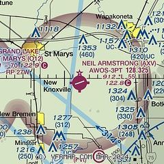
| Sectional chart |
|---|
|
| Airport distance calculator |
|---|
|
|
| Sunrise and sunset |
|---|
|
Times for 02-Feb-2026
| | Local
(UTC-5) | | Zulu
(UTC) |
|---|
| Morning civil twilight | | 07:18 | | 12:18 |
| Sunrise | | 07:47 | | 12:47 |
| Sunset | | 17:55 | | 22:55 |
| Evening civil twilight | | 18:24 | | 23:24 |
|
| Current date and time |
|---|
| Zulu (UTC) | 02-Feb-2026 20:14:49 |
|---|
| Local (UTC-5) | 02-Feb-2026 15:14:49 |
|---|
|
| METAR |
|---|
| KAXV | 021955Z AUTO 22009KT 10SM OVC016 M03/M07 A3008 RMK AO2
|
KAOH
18nm NE | 021953Z AUTO 21009KT 6SM HZ OVC015 M06/M09 A3007 RMK AO2 SLP203 T10561089
|
|
| TAF |
|---|
KDAY
36nm S | 021740Z 0218/0318 21009KT P6SM BKN027 FM022200 22009KT 5SM BR BKN015 FM031300 00000KT 2SM -SN OVC011 PROB30 0315/0318 1SM -SN OVC007
|
KFFO
42nm S | 021545Z 0215/0317 VRB06KT 9999 OVC070 620705 QNH3014INS TEMPO 0215/0219 18009KT 9000 -SN OVC015 620159 BECMG 0217/0219 21009KT 6000 -SN OVC015 620159 QNH3009INS BECMG 0220/0221 24009KT 9999 NSW OVC010 620104 QNH3008INS BECMG 0300/0301 VRB06KT 9999 OVC015 620153 QNH3013INS BECMG 0305/0306 VRB06KT 9999 OVC020 620202 620804 QNH3014INS BECMG 0311/0312 27009KT 6000 -SN SCT007 OVC010 620109 621002 QNH3015INS TXM02/0221Z TNM07/0215Z
|
KFDY
43nm NE | 021740Z 0218/0318 21009KT 6SM -SN OVC028 FM022100 23010KT P6SM OVC018 FM030000 24007KT P6SM OVC008 FM030600 26005KT P6SM OVC025 FM031700 28005KT P6SM OVC035
|
|
| NOTAMs |
|---|
NOTAMs are issued by the DoD/FAA and will open in a separate window not controlled by AirNav.
|
|


