FAA INFORMATION EFFECTIVE 14 MAY 2026
Location
| FAA Identifier: | BCR |
| Lat/Long: | 30-50-37.9880N 085-36-06.2980W
30-50.633133N 085-36.104967W
30.8438856,-85.6017494
(estimated) |
| Elevation: | 86 ft. / 26.2 m (surveyed) |
| Variation: | 03W (2010) |
| From city: | 6 miles NE of BONIFAY, FL |
| Time zone: | UTC -5 (UTC -6 during Standard Time) |
| Zip code: | 32425 |
Airport Operations
| Airport use: | Open to the public |
| Activation date: | 02/1975 |
| Control tower: | no |
| ARTCC: | JACKSONVILLE CENTER |
| FSS: | GAINESVILLE FLIGHT SERVICE STATION |
| NOTAMs facility: | GNV (NOTAM-D service available) |
| Attendance: | MON-FRI 0830-1630 |
| Wind indicator: | lighted |
| Segmented circle: | yes |
| Lights: | ACTVT PAPI RWY 01 & 19; MIRL RWY 01/19 - CTAF. |
| Beacon: | white-green (lighted land airport)
Operates sunset to sunrise. |
Airport Communications
| CTAF/UNICOM: | 122.725 |
| WX ASOS: | 119.825 (850-949-3178) |
| CAIRNS APPROACH: | 133.75 |
| CAIRNS DEPARTURE: | 133.75 |
- APCH/DEP SVC PRVDD BY JACKSONVILLE ARTCC ON FREQS 134.3/322.55 (DOTHAN RCAG) WHEN CAIRNS APCH/DEP CLSD.
Nearby radio navigation aids
| VOR radial/distance | | VOR name | | Freq | | Var |
|---|
| MAIr278/24.8 | | MARIANNA VORTAC | | 114.00 | | 00E |
| OZRr169/26.3 | | CAIRNS VOR/DME | | 111.20 | | 03W |
| RRSr196/27.9 | | WIREGRASS VORTAC | | 111.60 | | 02E |
| EDNr153/(31.2) | | ENTERPRISE VOR | | 116.60 | | 03W |
| HEYr178/(31.9) | | HANCHEY VOR | | 110.60 | | 03W |
| NDB name | | Hdg/Dist | | Freq | | Var | | ID |
|---|
| BOLL WEEVIL | | 150/35.6 | | 352 | | 03W | | BVG | -... ...- --. |
Airport Services
| Fuel available: | 100LL JET-A
100LL:SELF SVC FUEL AVBL. |
| Parking: | hangars and tiedowns |
| Airframe service: | NONE |
| Powerplant service: | NONE |
| Bottled oxygen: | NONE |
| Bulk oxygen: | NONE |
Runway Information
Runway 1/19
| Dimensions: | 5398 x 75 ft. / 1645 x 23 m |
| Surface: | asphalt, in good condition |
| Weight bearing capacity: | | PCN 21 /F/B/W/T | | Single wheel: | 30.0 |
|
| Runway edge lights: | medium intensity |
| Operational restrictions: | RWY SAFETY AREA CONTAINS MULT WASHOUTS WI FIRST 1000 FT BOTH SIDES. FENCE 252 FT E OF CNTRLN PENETRATES TRSNL SFC. |
| RUNWAY 1 | | RUNWAY 19 |
| Latitude: | 30-50.194240N | | 30-51.072010N |
| Longitude: | 085-36.191647W | | 085-36.018263W |
| Elevation: | 86.0 ft. | | 84.0 ft. |
| Traffic pattern: | left | | left |
| Runway heading: | 013 magnetic, 010 true | | 193 magnetic, 190 true |
| Markings: | nonprecision, in good condition | | nonprecision, in good condition |
| Visual slope indicator: | 2-light PAPI on left (3.00 degrees glide path) | | 2-light PAPI on left (3.00 degrees glide path) |
| Touchdown point: | yes, no lights | | yes, no lights |
| Obstructions: | 10 ft. brush, 220 ft. from runway, 115 ft. right of centerline, 2:1 slope to clear | | 65 ft. trees, 1490 ft. from runway, 235 ft. left of centerline, 19:1 slope to clear |
Airport Ownership and Management from official FAA records
| Ownership: | Publicly-owned |
| Owner: | TRI COUNTY AIRPORT AUTHORITY
PO BOX 756
BONIFAY, FL 32425
Phone 850-703-6808
CTC PERSON: JACK LOCKE |
| Manager: | MARK WILSON
1983 TRI COUNTY AIRPORT RD
BONIFAY, FL 32425
Phone 850-703-6808 |
Additional Remarks
| A30A-01 | TREES WIDTH OF RWY 252 FT FM RWY END 300 FT E OF CNTRLN PENETRATE TRSNL SFC. |
| A30A-19 | HILL 3553-3725 FT AFT APCH END 320-750 FT R OF CNTRLN PENETRATES TRSNL SFC. |
| - | WILDLIFE ON RWY; MIL OPS DALGT HR. |
| - | FOR CD CTC CAIRNS APCH AT 334-255-8402, WHEN APCH CLSD CTC JACKSONVILLE ARTCC AT 904-845-1592. |
| - | EXTSV SKYDIVING OPS ON WKENDS. |
| - | TREES & FENCE FULL LEN OF RWY 01/19 252 FT TO 300 FT E OF CNTRLN PENTS THE TRANSITIONAL SFC OF RWY 01/19. |
Instrument Procedures
NOTE: All procedures below are presented as PDF files. If you need a reader for these files, you should download the free Adobe Reader.NOT FOR NAVIGATION. Please procure official charts for flight.
FAA instrument procedures published for use from 14 May 2026 at 0901Z to 11 June 2026 at 0900Z.
IAPs - Instrument Approach Procedures |
|---|
| RNAV (GPS) RWY 01 | |
download (217KB) |
| RNAV (GPS) RWY 19 | |
download (201KB) |
| NOTE: Special Alternate Minimums apply | |
download (126KB) |
| NOTE: Special Take-Off Minimums/Departure Procedures apply | |
download (403KB) |
Other nearby airports with instrument procedures:
33J - Geneva Municipal Airport (19 nm NW)
KMAI - Marianna Municipal Airport (22 nm E)
KOZR - Cairns Army Airfield (Fort Rucker) (27 nm N)
54J - DeFuniak Springs Airport (29 nm W)
KDHN - Dothan Regional Airport (30 nm N)
|
|

Road maps at:
MapQuest
Bing
Google
| Aerial photo |
|---|
WARNING: Photo may not be current or correct
 Photo by Brian Christopher
Photo taken 28-Sep-2005
Photo by Brian Christopher
Photo taken 28-Sep-2005
Do you have a better or more recent aerial photo of Tri-County Airport that you would like to share? If so, please send us your photo.
|
| Sectional chart |
|---|
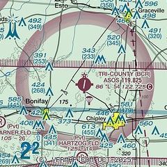
|
| Airport distance calculator |
|---|
|
|
| Sunrise and sunset |
|---|
|
Times for 08-Jun-2026
| | Local
(UTC-5) | | Zulu
(UTC) |
|---|
| Morning civil twilight | | 05:12 | | 10:12 |
| Sunrise | | 05:40 | | 10:40 |
| Sunset | | 19:43 | | 00:43 |
| Evening civil twilight | | 20:11 | | 01:11 |
|
| Current date and time |
|---|
| Zulu (UTC) | 08-Jun-2026 13:56:55 |
|---|
| Local (UTC-5) | 08-Jun-2026 08:56:55 |
|---|
|
| METAR |
|---|
| KBCR | 081258Z AUTO 06003KT 10SM CLR 24/22 A3011 RMK AO2 SLP153 T02440217 $
|
|
| TAF |
|---|
KOZR
27nm N | 081000Z 0810/0916 VRB06KT 9999 SCT050 BKN120 QNH3000INS TX33/0820Z TN22/0810Z
|
KDHN
29nm N | 081120Z 0812/0912 VRB03KT P6SM FEW040 BKN150 FM081600 16007KT P6SM SCT050 BKN250 FM090000 VRB04KT P6SM BKN250
|
KECP
31nm S | 081120Z 0812/0912 00000KT 1SM BR OVC001 FM081230 14006KT P6SM SCT030 BKN250 FM081700 18010KT P6SM FEW040 FM090100 VRB03KT P6SM SKC
|
|
| NOTAMs |
|---|
NOTAMs are issued by the DoD/FAA and will open in a separate window not controlled by AirNav.
|
|


