FAA INFORMATION EFFECTIVE 30 OCTOBER 2025
Location
| FAA Identifier: | MAI |
| Lat/Long: | 30-50-17.5970N 085-10-56.0050W
30-50.293283N 085-10.933417W
30.8382214,-85.1822236
(estimated) |
| Elevation: | 110.7 ft. / 33.7 m (surveyed) |
| Variation: | 02W (2000) |
| From city: | 4 miles NE of MARIANNA, FL |
| Time zone: | UTC -6 (UTC -5 during Daylight Saving Time) |
| Zip code: | 32443 |
Airport Operations
| Airport use: | Open to the public |
| Activation date: | 09/1943 |
| Control tower: | no |
| ARTCC: | JACKSONVILLE CENTER |
| FSS: | GAINESVILLE FLIGHT SERVICE STATION |
| NOTAMs facility: | MAI (NOTAM-D service available) |
| Attendance: | MON-FRI 0800-1700
EXCLUDING HOLIDAYS.
FOR SVC AFTER HRS CALL 850-482-2281. |
| Wind indicator: | lighted |
| Segmented circle: | yes |
| Lights: | ACTVT PAPI RWY 18 & 36; MIRL RWY 18/36 - CTAF. |
| Beacon: | white-green (lighted land airport)
Operates sunset to sunrise. |
Airport Communications
| CTAF/UNICOM: | 123.0 |
| WX ASOS: | 133.525 (850-482-6082) |
| CAIRNS APPROACH: | 133.75 |
| CAIRNS DEPARTURE: | 133.75 |
| WX AWOS-3PT at 17J (19 nm NE): | 119.675 (229-524-0001) |
- APCH/DEP SVC PRVDD BY JACKSONVILLE ARTCC ON FREQS 134.3/322.55 (DOTHAN RCAG) WHEN CAIRNS APCH/DEP CLSD.
Nearby radio navigation aids
| VOR radial/distance | | VOR name | | Freq | | Var |
|---|
| MAIr316/4.3 | | MARIANNA VORTAC | | 114.00 | | 00E |
| RRSr152/29.7 | | WIREGRASS VORTAC | | 111.60 | | 02E |
| OZRr136/38.1 | | CAIRNS VOR/DME | | 111.20 | | 03W |
| NDB name | | Hdg/Dist | | Freq | | Var | | ID |
|---|
| WILLIS | | 261/34.8 | | 359 | | 04W | | LYZ | .-.. -.-- --.. |
Airport Services
| Fuel available: | 100LL JET-A |
| Parking: | hangars and tiedowns |
| Airframe service: | MAJOR |
| Powerplant service: | MAJOR |
| Bottled oxygen: | NONE |
| Bulk oxygen: | NONE |
Runway Information
Runway 18/36
| Dimensions: | 6001 x 100 ft. / 1829 x 30 m |
| Surface: | asphalt, in good condition |
| Weight bearing capacity: | |
| Runway edge lights: | medium intensity |
| RUNWAY 18 | | RUNWAY 36 |
| Latitude: | 30-50.628167N | | 30-49.638300N |
| Longitude: | 085-11.139825W | | 085-11.139587W |
| Elevation: | 110.5 ft. | | 104.6 ft. |
| Traffic pattern: | left | | left |
| Runway heading: | 182 magnetic, 180 true | | 002 magnetic, 360 true |
| Markings: | precision, in fair condition | | nonprecision, in fair condition |
| Visual slope indicator: | 4-light PAPI on left (2.83 degrees glide path) | | 4-light PAPI on left (3.00 degrees glide path) |
| Touchdown point: | yes, no lights | | yes, no lights |
| Obstructions: | 30 ft. trees, 1050 ft. from runway, 35 ft. right of centerline, 28:1 slope to clear | | 61 ft. trees, 1950 ft. from runway, 185 ft. right of centerline, 28:1 slope to clear |
Runway 8/26
| Dimensions: | 4763 x 100 ft. / 1452 x 30 m |
| Surface: | asphalt, in poor condition
RWY 08/26 CRACKING WITH GRASS GROWING & PRODUCING LOOSE AGGREGATE. |
| Weight bearing capacity: | |
| Runway edge markings: | FADED. |
| RUNWAY 8 | | RUNWAY 26 |
| Latitude: | 30-50.440037N | | 30-50.549805N |
| Longitude: | 085-11.124283W | | 085-10.222693W |
| Elevation: | 110.0 ft. | | 108.9 ft. |
| Traffic pattern: | left | | left |
| Runway heading: | 084 magnetic, 082 true | | 264 magnetic, 262 true |
| Markings: | nonprecision, in poor condition | | nonprecision, in poor condition |
| Touchdown point: | yes, no lights | | yes, no lights |
| Obstructions: | 47 ft. trees, 1820 ft. from runway, 35 ft. left of centerline, 34:1 slope to clear | | 39 ft. pline, marked, 1440 ft. from runway, 31:1 slope to clear |
Airport Ownership and Management from official FAA records
| Ownership: | Publicly-owned |
| Owner: | MARIANNA MUNI AIRPORT AUTHORITY
P.O. BOX 936
MARIANNA, FL 32447
Phone 850-482-
CONTACT PERSON: WILLIAM LONG, CITY MANAGER 850-482-4353. |
| Manager: | DOUG GLASS
MARIANNA MUNICIPAL AIRPORT, 3689 INDUSTRIAL PARK DR
MARIANNA, FL 32446
Phone 850-482-2281 |
Additional Remarks
| - | MIL HEL OPS ON & INVOF ARPT. |
| - | FOR CD CTC CAIRNS APCH AT 334-255-8402, WHEN APCH CLSD CTC JACKSONVILLE ARTCC AT 904-845-1592. |
Instrument Procedures
NOTE: All procedures below are presented as PDF files. If you need a reader for these files, you should download the free Adobe Reader.NOT FOR NAVIGATION. Please procure official charts for flight.
FAA instrument procedures published for use from 30 October 2025 at 0901Z to 27 November 2025 at 0900Z.
IAPs - Instrument Approach Procedures |
|---|
| RNAV (GPS) RWY 18 | |
download (254KB) |
| VOR-A | |
download (192KB) |
| NOTE: Special Alternate Minimums apply | |
download (148KB) |
| NOTE: Special Take-Off Minimums/Departure Procedures apply | |
download (397KB) |
Other nearby airports with instrument procedures:
17J - Donalsonville Municipal Airport (19 nm NE)
KBCR - Tri-County Airport (22 nm W)
KBGE - Decatur County Industrial Air Park (29 nm E)
KDHN - Dothan Regional Airport (32 nm NW)
KHDL - Headland Municipal Airport (32 nm N)
|
|

Road maps at:
MapQuest
Bing
Google
| Aerial photo |
|---|
WARNING: Photo may not be current or correct
 Photo by Frank Daniels and Alex Nowell
Photo taken 10-Mar-2009
Photo by Frank Daniels and Alex Nowell
Photo taken 10-Mar-2009
Do you have a better or more recent aerial photo of Marianna Municipal Airport that you would like to share? If so, please send us your photo.
|
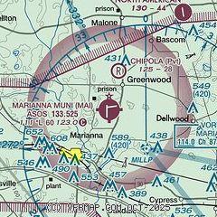
| Sectional chart |
|---|
|
CAUTION: Diagram may not be current

| Airport distance calculator |
|---|
|
|
| Sunrise and sunset |
|---|
|
Times for 20-Nov-2025
| | Local
(UTC-6) | | Zulu
(UTC) |
|---|
| Morning civil twilight | | 05:47 | | 11:47 |
| Sunrise | | 06:13 | | 12:13 |
| Sunset | | 16:40 | | 22:40 |
| Evening civil twilight | | 17:06 | | 23:06 |
|
| Current date and time |
|---|
| Zulu (UTC) | 20-Nov-2025 12:27:01 |
|---|
| Local (UTC-6) | 20-Nov-2025 06:27:01 |
|---|
|
| METAR |
|---|
| KMAI | 201220Z AUTO 1 1/4SM BR OVC002 13/13 A3017 RMK AO2 T01280128
|
|
| TAF |
|---|
KDHN
32nm NW | 201120Z 2012/2112 00000KT 3SM BR SCT002 TEMPO 2012/2014 1/2SM FG VV002 FM201500 19005KT P6SM SCT040 FM210900 00000KT 1SM BR SCT050
|
KOZR
38nm NW | 201000Z 2010/2116 VRB04KT 6000 BR FEW002 QNH3012INS BECMG 2011/2012 VRB04KT 0800 FG OVC002 QNH3014INS BECMG 2015/2016 VRB06KT 9999 NSW FEW005 SCT012 QNH3014INS BECMG 2016/2017 18006KT 9999 SCT035 QNH3002INS BECMG 2107/2108 VRB04KT 4800 BR SCT004 QNH3004INS BECMG 2109/2110 VRB04KT 0800 FG OVC002 QNH3006INS TX28/2020Z TN14/2010Z
|
|
| NOTAMs |
|---|
NOTAMs are issued by the DoD/FAA and will open in a separate window not controlled by AirNav.
|
|


