FAA INFORMATION EFFECTIVE 14 MAY 2026
Location
| FAA Identifier: | BRO |
| Lat/Long: | 25-54-22.1000N 097-25-33.6000W
25-54.368333N 097-25.560000W
25.9061389,-97.4260000
(estimated) |
| Elevation: | 22.4 ft. / 6.8 m (surveyed) |
| Variation: | 03E (2020) |
| From city: | 4 miles E of BROWNSVILLE, TX |
| Time zone: | UTC -5 (UTC -6 during Standard Time) |
| Zip code: | 78521 |
Airport Operations
| Airport use: | Open to the public |
| Activation date: | 09/1937 |
| Control tower: | yes |
| ARTCC: | HOUSTON CENTER |
| FSS: | SAN ANGELO FLIGHT SERVICE STATION |
| NOTAMs facility: | BRO (NOTAM-D service available) |
| Attendance: | CONTINUOUS
FOR ACFT SVC CALL 956-542-5852 OR 956-542-9111. |
| Wind indicator: | lighted |
| Segmented circle: | yes |
| Lights: | DUSK-DAWN. WHEN ATCT CLSD ACTVT MALSR RWY 13 - CTAF. |
| Beacon: | white-green (lighted land airport)
Operates sunset to sunrise. |
| Landing fee: | yes |
| Fire and rescue: | ARFF index B |
| Airline operations: | WHEN ATCT CLSD REQ ARFF ASSISTANCE THRU HOUSTON ARTCC OR FLT SVC. PPR 24 HRS FOR UNSKED ACR OPNS WITH MORE THAN 30 PSGR SEATS CALL AMGR 956-542-4373. |
| International operations: | international airport of entry |
Airport Communications
| CTAF: | 118.9 |
| UNICOM: | 122.95 |
| ATIS: | 128.55 |
| WX ASOS: | 128.55 (956-299-5871) |
| BROWNSVILLE GROUND: | 121.9 [0600-0000] |
| BROWNSVILLE TOWER: | 118.9 239.3 [0600-0000] |
| VALLEY APPROACH: | 119.5 |
| VALLEY DEPARTURE: | 119.5 |
| EMERG: | 121.5 243.0 |
| WX ASOS at PIL (16 nm N): | 118.525 (956-233-1954) |
Nearby radio navigation aids
| VOR radial/distance | | VOR name | | Freq | | Var |
|---|
| BROr240/2.9 | | BROWNSVILLE VORTAC | | 116.30 | | 09E |
| MAMr029/9.7 | | MATAMOROS VOR/DME | | 114.30 | | 04E |
| HRLr143/22.9 | | HARLINGEN VOR/DME | | 113.65 | | 05E |
| NDB name | | Hdg/Dist | | Freq | | Var | | ID |
|---|
| DEPOO | | 133/6.5 | | 393 | | 03E | | BR | -... .-. |
Airport Services
| Fuel available: | 100LL JET-A |
| Parking: | hangars and tiedowns |
| Airframe service: | MAJOR |
| Powerplant service: | MAJOR |
| Bottled oxygen: | HIGH |
| Bulk oxygen: | HIGH |
Runway Information
Runway 13/31
| Dimensions: | 7399 x 150 ft. / 2255 x 46 m |
| Surface: | asphalt/grooved, in good condition |
| Weight bearing capacity: | | Single wheel: | 75.0 | | Double wheel: | 170.0 | | Double tandem: | 240.0 |
|
| Runway edge lights: | high intensity |
| RUNWAY 13 | | RUNWAY 31 |
| Latitude: | 25-54.769345N | | 25-53.899642N |
| Longitude: | 097-25.878205W | | 097-24.930022W |
| Elevation: | 17.3 ft. | | 20.0 ft. |
| Traffic pattern: | left | | left |
| Runway heading: | 132 magnetic, 135 true | | 312 magnetic, 315 true |
| Declared distances: | TORA:7399 TODA:7399 ASDA:7399 LDA:7399 | | TORA:7399 TODA:7399 ASDA:7399 LDA:7399 |
| Markings: | precision, in good condition | | precision, in good condition |
| Visual slope indicator: | | | 4-light PAPI on left (3.00 degrees glide path) |
| RVR equipment: | touchdown | | rollout |
| Approach lights: | MALSR: 1,400 foot medium intensity approach lighting system with runway alignment indicator lights | | |
| Touchdown point: | yes, no lights | | yes, no lights |
| Instrument approach: | ILS/DME | | |
| Obstructions: | 31 ft. tree, 1224 ft. from runway, 369 ft. left of centerline, 33:1 slope to clear | | 24 ft. tree, 751 ft. from runway, 611 ft. left of centerline, 22:1 slope to clear |
Runway 18/36
| Dimensions: | 6000 x 150 ft. / 1829 x 46 m |
| Surface: | asphalt/grooved, in fair condition |
| Weight bearing capacity: | | Single wheel: | 75.0 | | Double wheel: | 144.0 | | Double tandem: | 150.0 |
|
| Runway edge lights: | medium intensity |
| RUNWAY 18 | | RUNWAY 36 |
| Latitude: | 25-54.904458N | | 25-53.914683N |
| Longitude: | 097-25.731002W | | 097-25.771965W |
| Elevation: | 19.7 ft. | | 22.3 ft. |
| Traffic pattern: | left | | left |
| Runway heading: | 179 magnetic, 182 true | | 359 magnetic, 002 true |
| Displaced threshold: | 190 ft. | | no |
| Declared distances: | TORA:6000 TODA:6000 ASDA:6000 LDA:5810 | | TORA:5532 TODA:5532 ASDA:5532 LDA:5532 |
| Markings: | nonprecision, in good condition | | nonprecision, in good condition |
| Visual slope indicator: | 4-light PAPI on left (3.00 degrees glide path) | | 4-box VASI on left (3.00 degrees glide path) |
| Touchdown point: | yes, no lights | | yes, no lights |
| Obstructions: | 37 ft. tree, 722 ft. from runway, 140 ft. left of centerline, 14:1 slope to clear | | 30 ft. tree, 660 ft. from runway, 312 ft. right of centerline, 15:1 slope to clear |
Airport Ownership and Management from official FAA records
| Ownership: | Publicly-owned |
| Owner: | CITY OF BROWNSVILLE
BOX 911
BROWNSVILLE, TX 78520
Phone 956-542-4373 |
| Manager: | FAISAL KHALIFA- INTERIM AIRPORT DIR
700 AMELIA EARHART
BROWNSVILLE, TX 78521-5721
Phone 956-459-1811
INTERIM DIRECTOR OF AVIATION. |
Additional Remarks
| A39-18/36 | PCR VALUE: 540/F/D/X/T |
| A39-13/31 | PCR VALUE: 660/F/B/X/T |
| - | FLIGHT NOTIFICATION SERVICE (ADCUS) AVAILABLE. |
| - | LGTD OIL DERRICKS LCTN APRXLY 5 NM NE MAX 500 FT AGL. |
| - | BIRDS ON & INVOF ARPT. |
| - | FOR CD WHEN ATCT IS CLSD CTC CRP APCH AT 361-299-4230. |
| - | TXY J NORTH OF TXY H OPEN TO TFC UNDER 12500 LBS. |
| - | FOR CUST AND BDR PROTECTION SVCS CTC: 956-547-5760 DLY 0800-2400; KBRO.GAP@CBP.DHS.GOV. AFT HRS: 956-983-5704, 956-982-3653; BROWNSVILLEOPSCENTER@CBP.DHS.GOV. |
Instrument Procedures
NOTE: All procedures below are presented as PDF files. If you need a reader for these files, you should download the free Adobe Reader.NOT FOR NAVIGATION. Please procure official charts for flight.
FAA instrument procedures published for use from 14 May 2026 at 0901Z to 11 June 2026 at 0900Z.
IAPs - Instrument Approach Procedures |
|---|
| ILS OR LOC RWY 13 | |
download (309KB) |
| RNAV (GPS) RWY 13 | |
download (308KB) |
| RNAV (GPS) RWY 18 | |
download (233KB) |
| RNAV (GPS) RWY 31 | |
download (253KB) |
| LOC BC RWY 31 | |
download (314KB) |
| VOR OR TACAN-A | |
download (249KB) |
| NOTE: Special Alternate Minimums apply | |
download (120KB) |
| NOTE: Special Take-Off Minimums/Departure Procedures apply | |
download (149KB) |
Other nearby airports with instrument procedures:
KPIL - Cameron County Airport (16 nm N)
KHRL - Valley International Airport (23 nm NW)
KTXW - Mid Valley Airport (34 nm NW)
KMFE - Mc Allen International Airport (47 nm W)
KEBG - South Texas International Airport at Edinburg (49 nm NW)
|
|

Road maps at:
MapQuest
Bing
Google
| Aerial photo |
|---|
WARNING: Photo may not be current or correct
 Photo courtesy of the Airport Administration
Taken in October 2016
looking east-southeast.
Photo courtesy of the Airport Administration
Taken in October 2016
looking east-southeast.
Do you have a better or more recent aerial photo of Brownsville/South Padre Island International Airport that you would like to share? If so, please send us your photo.
|
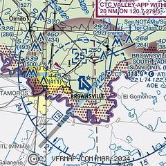
| Sectional chart |
|---|
|
CAUTION: Diagram may not be current
 Download PDF
of official airport diagram from the FAA
| Airport distance calculator |
|---|
|
|
| Sunrise and sunset |
|---|
|
Times for 02-Jun-2026
| | Local
(UTC-5) | | Zulu
(UTC) |
|---|
| Morning civil twilight | | 06:13 | | 11:13 |
| Sunrise | | 06:39 | | 11:39 |
| Sunset | | 20:17 | | 01:17 |
| Evening civil twilight | | 20:42 | | 01:42 |
|
| Current date and time |
|---|
| Zulu (UTC) | 02-Jun-2026 13:34:44 |
|---|
| Local (UTC-5) | 02-Jun-2026 08:34:44 |
|---|
|
| METAR |
|---|
| KBRO | 021253Z 09003KT 10SM CLR 28/26 A2991 RMK AO2 SLP128 T02830256 $
|
MMMA
10nm SW | 021110Z RTD 08003KT 6SM FEW008 25/25 A2990 RMK 8/500 HZY ISOL CI MSGTX MMMX
|
KPIL
16nm N | 021253Z AUTO 00000KT 10SM CLR 27/26 A2992 RMK AO2 SLP131 T02720256
|
|
| TAF |
|---|
| KBRO | 021120Z 0212/0312 13005KT P6SM FEW015 FM021600 10010KT P6SM SCT050 TEMPO 0216/0220 SHRA FM030200 12005KT P6SM FEW020
|
MMMA
10nm SW | 020553Z 0206/0306 13005KT P6SM SCT015 FM021400 10010KT P6SM SCT020 TEMPO 0215/0219 5SM RA FM030200 12005KT P6SM SCT020
|
|
| NOTAMs |
|---|
NOTAMs are issued by the DoD/FAA and will open in a separate window not controlled by AirNav.
|
|


