FAA INFORMATION EFFECTIVE 25 DECEMBER 2025
Location
| FAA Identifier: | CCO |
| Lat/Long: | 33-18-41.6360N 084-46-11.1195W
33-18.693933N 084-46.185325W
33.3115656,-84.7697554
(estimated) |
| Elevation: | 970.2 ft. / 295.7 m (surveyed) |
| Variation: | 03W (2000) |
| From city: | 4 miles S of ATLANTA, GA |
| Time zone: | UTC -5 (UTC -4 during Daylight Saving Time) |
| Zip code: | 30263 |
Airport Operations
| Airport use: | Open to the public |
| Control tower: | no |
| ARTCC: | ATLANTA CENTER |
| FSS: | MACON FLIGHT SERVICE STATION |
| NOTAMs facility: | MCN (NOTAM-D service available) |
| Attendance: | M-F 0700-2000, ALL S-S 0800-1800 |
| Wind indicator: | lighted |
| Segmented circle: | yes |
| Lights: | ACTVT MALSF RWY 33; HIRL RWY 15/33 - CTAF. |
| Beacon: | white-green (lighted land airport)
Operates sunset to sunrise. |
Airport Communications
| CTAF/UNICOM: | 122.7 |
| WX AWOS-3PT: | 118.975 (770-254-1617) |
| ATLANTA APPROACH: | 119.8 |
| ATLANTA DEPARTURE: | 119.8 |
| WX ASOS at FFC (10 nm E): | 118.525 (770-487-1610) |
Nearby radio navigation aids
| VOR radial/distance | | VOR name | | Freq | | Var |
|---|
| LGCr053/27.0 | | LAGRANGE VORTAC | | 115.60 | | 01E |
| NDB name | | Hdg/Dist | | Freq | | Var | | ID |
|---|
| COWETA COUNTY | | 322/4.3 | | 234 | | 03W | | EQQ | . --.- --.- |
| PECAT | | 278/14.2 | | 316 | | 05W | | FFC | ..-. ..-. -.-. |
| CARROLLTON | | 134/23.7 | | 278 | | 04W | | GPQ | --. .--. --.- |
Airport Services
| Fuel available: | 100LL JET-A+ |
| Parking: | tiedowns |
| Airframe service: | MAJOR |
| Powerplant service: | MAJOR |
| Bottled oxygen: | LOW |
| Bulk oxygen: | NONE |
Runway Information
Runway 15/33
| Dimensions: | 5500 x 100 ft. / 1676 x 30 m |
| Surface: | asphalt, in fair condition |
| Weight bearing capacity: | | Single wheel: | 26.0 | | Double wheel: | 37.0 |
|
| Runway edge lights: | high intensity |
| RUNWAY 15 | | RUNWAY 33 |
| Latitude: | 33-19.038500N | | 33-18.349367N |
| Longitude: | 084-46.536350W | | 084-45.834300W |
| Elevation: | 970.2 ft. | | 928.9 ft. |
| Traffic pattern: | left | | left |
| Runway heading: | 142 magnetic, 139 true | | 322 magnetic, 319 true |
| Markings: | precision, in good condition | | precision, in good condition |
| Visual slope indicator: | 4-light PAPI on left (3.00 degrees glide path) | | 4-light PAPI on left (3.00 degrees glide path) |
| Approach lights: | | | MALSF: 1,400 foot medium intensity approach lighting system with sequenced flashers |
| Touchdown point: | yes, no lights | | yes, no lights |
| Instrument approach: | | | LOC/GS |
| Obstructions: | 64 ft. trees, 927 ft. from runway, 582 ft. left of centerline, 11:1 slope to clear
15 FT POWER POLES, 139 FT FROM EOR, 355 FT RIGHT OF CNTRLN. | | 30 ft. trees, 201 ft. from runway, 345 ft. right of centerline
30 FT TREES, 264 FT RIGHT OF CNTRLN AT RWY END OUT TO 200 FT FM RWY END. |
Airport Ownership and Management from official FAA records
| Ownership: | Publicly-owned |
| Owner: | NEWNAN & COWETA CO ARPT AUTH
115 AIRPORT ROAD, BOX 2
NEWNAN, GA 30263
Phone 770-254-8102 |
| Manager: | CALVIN WALKER
115 AIRPORT ROAD, BOX 2
NEWNAN, GA 30263
Phone 770-254-8102 |
Additional Remarks
| - | GCO AVBL ON FREQ 121.725 THRU FLT SVCS. |
| - | WILDLIFE INVOF ARPT. |
| - | EXTENSIVE FLIGHT TRAINING ON AND INVOF AIRPORT |
| - | FOR CD CTC ATLANTA APCH AT 678-364-6131. |
Instrument Procedures
NOTE: All procedures below are presented as PDF files. If you need a reader for these files, you should download the free Adobe Reader.NOT FOR NAVIGATION. Please procure official charts for flight.
FAA instrument procedures published for use from 25 December 2025 at 0901z to 22 January 2026 at 0900z.
STARs - Standard Terminal Arrivals |
|---|
| BUKHD THREE (RNAV) | |
download (190KB) |
| DEHAN THREE (RNAV) | |
2 pages:
[1] [2] (325KB) |
IAPs - Instrument Approach Procedures |
|---|
| ILS OR LOC RWY 33 | |
download (232KB) |
| RNAV (GPS) RWY 15 | |
download (227KB) |
| RNAV (GPS) RWY 33 | |
download (240KB) |
| NOTE: Special Alternate Minimums apply | |
download (162KB) |
| NOTE: Special Take-Off Minimums/Departure Procedures apply | |
download |
Other nearby airports with instrument procedures:
KFFC - Atlanta Regional Airport-Falcon Field (10 nm E)
KHMP - Atlanta Speedway Airport (22 nm E)
KLGC - LaGrange-Callaway Airport (24 nm SW)
6A2 - Griffin-Spalding County Airport (25 nm E)
KATL - Hartsfield/Jackson Atlanta International Airport (26 nm NE)
|
|

Road maps at:
MapQuest
Bing
Google
| Aerial photo |
|---|
WARNING: Photo may not be current or correct
 Photo courtesy of AirNav, LLC
Photo taken 05-May-2011
looking northwest.
Photo courtesy of AirNav, LLC
Photo taken 05-May-2011
looking northwest.
Do you have a better or more recent aerial photo of Newnan Coweta County Airport that you would like to share? If so, please send us your photo.
|
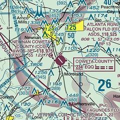
| Sectional chart |
|---|
|
CAUTION: Diagram may not be current

| Airport distance calculator |
|---|
|
|
| Sunrise and sunset |
|---|
|
Times for 21-Jan-2026
| | Local
(UTC-5) | | Zulu
(UTC) |
|---|
| Morning civil twilight | | 07:15 | | 12:15 |
| Sunrise | | 07:42 | | 12:42 |
| Sunset | | 17:59 | | 22:59 |
| Evening civil twilight | | 18:26 | | 23:26 |
|
| Current date and time |
|---|
| Zulu (UTC) | 21-Jan-2026 15:26:10 |
|---|
| Local (UTC-5) | 21-Jan-2026 10:26:10 |
|---|
|
| METAR |
|---|
| KCCO | 211515Z AUTO 13007KT 10SM CLR 03/M09 A3045 RMK AO2 T00251090
|
KFFC
10nm E | 211453Z AUTO 15003KT 10SM CLR M01/M07 A3047 RMK AO2 SLP327 T10061067 51009
|
|
| TAF |
|---|
KATL
25nm NE | 211357Z 2114/2218 11006KT P6SM FEW250 FM211600 16007KT P6SM FEW100 SCT200 FM212200 17005KT P6SM SCT050 BKN100 FM220500 19004KT P6SM VCSH OVC035 FM220900 24003KT P6SM VCSH SCT015 OVC025 PROB30 2209/2215 5SM -SHRA BR OVC015 FM221500 29004KT 5SM -SHRA BR SCT008 OVC012
|
KFTY
31nm NE | 211126Z 2112/2212 00000KT P6SM FEW250 FM211600 14006KT P6SM FEW050 SCT100 BKN200 FM212300 17004KT P6SM SCT050 BKN090 FM220500 VRB03KT P6SM OVC035 FM220800 VRB03KT P6SM VCSH SCT015 OVC025 PROB30 2208/2212 5SM -SHRA BR OVC015
|
|
| NOTAMs |
|---|
NOTAMs are issued by the DoD/FAA and will open in a separate window not controlled by AirNav.
|
|


