FAA INFORMATION EFFECTIVE 09 JULY 2026
Location
| FAA Identifier: | EOD |
| Lat/Long: | 36-34-03.5495N 087-28-53.2497W
36-34.059158N 087-28.887495W
36.5676526,-87.4814583
(estimated) |
| Elevation: | 595.2 ft. / 181.4 m (surveyed) |
| Variation: | 03W (2010) |
| From city: | 7 miles NW of FORT CAMPBELL (CLARKSVILLE), TN |
| Time zone: | UTC -5 (UTC -6 during Standard Time) |
| Zip code: | 42223 |
Airport Operations
| Airport use: | Private use. Permission required prior to landing |
| Control tower: | yes |
| ARTCC: | MEMPHIS CENTER |
| FSS: | JACKSON FLIGHT SERVICE STATION |
| NOTAMs facility: | MKL (NOTAM-D service available) |
| Attendance: | FRI 0800-1600, ALL MON-THU 0800-2400
REMARKS - OPR 1400-0600Z++ MON-FRI, EXC HOL; BASE OPS 1400-2300Z++ MON-FRI, EXC HOL. WHEN BASE OPS CLSD, CTC CAMPBELL BASE OPS 130.65 142.9 230.1, C270-798-7163/64. CK NOTAM FOR POSSIBLE CHG TO OPR HR. |
| Wind indicator: | lighted |
| Segmented circle: | no |
| Lights: | ACTVT HIRL RWY 05/23 - CTAF. |
| Beacon: | white (unlighted land airport)
Operates sunset to sunrise. |
Airport Communications
| CTAF: | 124.675 |
| ATIS: | 306.5 |
| WX AWOS-3: | PHONE 270-956-3100 |
| SABRE GROUND: | 142.975 267.3 [OPR HX, CTC BASE OPS FOR INFO. DSN 635-6122 FOR PPR-6115.] |
| SABRE TOWER: | 124.675 290.45 [OPR HX, CTC BASE OPS FOR INFO. DSN 635-6122 FOR PPR-6115.] |
| CAMPBELL APPROACH: | 134.35 |
| CAMPBELL DEPARTURE: | 134.35 |
| OPS: | 139.9 ;EAGLE CON 285.7 ;EAGLE CON 285.7 ;EAGLE RDO |
| PTD: | 138.7 |
| WX ASOS at CKV (5 nm NE): | 134.575 (931-431-3045) |
| WX AWOS-3 at HVC (17 nm N): | 132.575 (270-886-6311) |
- COMMUNICATIONS - CTAF - 124.675 PTD - 138.7 ATIS - 306.5 CAMPBELL APP/DEP - (R) (E) OPR H24 134.35, 307.025. TWR: (E) OPR 124.675 & 290.45. REMARKS: OPR 1400-0600Z++ MON-FRI EXC HOL, OT USE CTAF AND CTC CAMPBELL APP 134.35, OR 307.025 AIRBORNE; 237.6 ON GND. GND: 142.975 267.3. CLNC DEL: 237.6. REMARKS: WHEN UNAVBL VIA 237.6, CTC CAMPBELL APP AT 270-798-6441. EAGLE RDO - 139.9 285.7. FSS-JACKSON MKL-NOTAM MKL.
Nearby radio navigation aids
| VOR radial/distance | | VOR name | | Freq | | Var |
|---|
| CKVr226/4.6 | | CLARKSVILLE VOR/DME | | 110.60 | | 01W |
| NDB name | | Hdg/Dist | | Freq | | Var | | ID |
|---|
| SNUFF | | 299/5.2 | | 335 | | 01W | | CK | -.-. -.- |
| AIRBE | | 199/10.7 | | 273 | | 01W | | FK | ..-. -.- |
Airport Services
Runway Information
Runway 5/23
| Dimensions: | 5000 x 100 ft. / 1524 x 30 m |
| Surface: | concrete |
| Weight bearing capacity: | |
| Runway edge lights: | high intensity |
| RUNWAY 5 | | RUNWAY 23 |
| Latitude: | 36-33.761165N | | 36-34.357152N |
| Longitude: | 087-29.240893W | | 087-28.534097W |
| Elevation: | 595.2 ft. | | 573.4 ft. |
| Traffic pattern: | left | | left |
| Markings: | precision, in good condition | | precision, in good condition |
| Touchdown point: | yes, no lights | | yes, no lights |
Airport Ownership and Management from official FAA records
| Ownership: | U.S. Army |
| Owner: | US ARMY ATCA-ASO
9325 GUNSTON ROAD
FT BELVOIR, VA 22060 |
| Manager: | BILL ZIENTEK
Phone 270 798 9451 |
Additional Remarks
| - | RSTD - 24 HR PPR FOR F/W AND CIV ACFT. CTC BASE OPS C270-798-6122 DSN 635-6122 FOR PPR. EMERG PRO TRNG AND HOT REFUEL NOT AUTH WHEN ARFF EQPT NOT ON SITE. |
| - | MISC - CLASS D AIRSPACE REMAINS CLASS D WHEN TWR CLSD, USE CTAF AND CONTACT CAMPBELL APP 134.35 OR 307.025 PRIOR TO ENTERING CLASS D OR 237.6 ON THE GND. WHEN SABRE TWR AND BASE OPS CLSD, OPEN-CLOSE FLT PLAN WITH CAMPBELL BASE OPS. |
| - | MISC - NO TRML FCST ISSUED FOR SABRE AAF. |
| - | RSTD - TSNT PILOTS PLANNING TO CONDUCT OPR WI R3701 OR R3702 MUST RCV A BRIEF PRIOR TO FLT, CONTACT EAGLE RDO C270-798-2967. |
| - | TFC PAT - R/W DAY/NVD 900 FT, R/W NGT UNAIDED 1300 FT, UAS 1300 FT, F/W 2100 FT, OVERHEAD 2600 FT. F/W RGT TFC RWY 05, LFT TFC RWY 23 RGT TFC RWY 23, LFT TFC RWY 05. UAS LFT TFC RWY 05, RGT TFC RWY 23. |
| - | MISC - LTD TRAN PRK. LGTD HELIPAD NE TWY A. CK NOTAM FOR POSSIBLE CHG TO OPR HR. |
| - | CAUTION - UNMANNED ACFT IN CLASS D. |
| - | OPR 1400-0600Z++ MON-FRI, EXC HOL; BASE OPS 1400-2300Z++ MON-FRI, EXC HOL. WHEN BASE OPS CLSD, CTC CAMPBELL BASE OPS 130.65, 142.9 & 230.1, C270-798-7163/64. CK NOTAM FOR POSSIBLE CHG TO OPR HR. |
| - | FOR CD WHEN UNA VIA FREQ CTC CAMPBELL APCH AT 270-798-6441. |
Instrument Procedures
NOTE: All procedures below are presented as PDF files. If you need a reader for these files, you should download the free Adobe Reader.NOT FOR NAVIGATION. Please procure official charts for flight.
FAA instrument procedures published for use from 09 July 2026 at 0901Z to 06 August 2026 at 0900Z.
IAPs - Instrument Approach Procedures |
|---|
| RNAV (GPS) X RWY 05 | |
download (114KB) |
| RNAV (GPS) X RWY 23 | |
download (88KB) |
| COPTER RNAV (GPS) Y RWY 05 | |
download (115KB) |
| COPTER RNAV (GPS) Y RWY 23 | |
download (109KB) |
| COPTER VOR RWY 23 | |
download (114KB) |
| COPTER NDB 303 | |
download (112KB) |
| Radar Approach Procedures available | |
download (130KB) |
| NOTE: Special Take-Off Minimums/Departure Procedures apply | |
download (400KB) |
Other nearby airports with instrument procedures:
KCKV - Outlaw Field Airport (5 nm NE)
KHOP - Campbell Army Airfield (Fort Campbell) (6 nm N)
KHVC - Hopkinsville-Christian County Airport (17 nm N)
M02 - Dickson Municipal Airport (26 nm S)
M91 - Springfield Robertson County Airport (27 nm E)
|
|

Road maps at:
MapQuest
Bing
Google
| Aerial photo |
|---|
WARNING: Photo may not be current or correct

Do you have a better or more recent aerial photo of Sabre Army Airfield (Fort Campbell) that you would like to share? If so, please send us your photo.
|
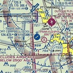
| Sectional chart |
|---|
|
 Download PDF
of official airport diagram from the FAA
| Airport distance calculator |
|---|
|
|
| Sunrise and sunset |
|---|
|
Times for 24-Jul-2026
| | Local
(UTC-5) | | Zulu
(UTC) |
|---|
| Morning civil twilight | | 05:22 | | 10:22 |
| Sunrise | | 05:51 | | 10:51 |
| Sunset | | 20:02 | | 01:02 |
| Evening civil twilight | | 20:31 | | 01:31 |
|
| Current date and time |
|---|
| Zulu (UTC) | 25-Jul-2026 01:22:59 |
|---|
| Local (UTC-5) | 24-Jul-2026 20:22:59 |
|---|
|
| METAR |
|---|
| KEOD | 242355Z AUTO 00000KT 10SM CLR 25/20 A3010 RMK AO2 SLP191 P0000 60000 T02470197 10284 20237 57003
|
KCKV
4nm NE | 250052Z AUTO 09003KT 10SM SCT120 24/19 A3008 RMK AO2 SLP179 T02390189
|
KHOP
6nm N | 250055Z AUTO 04003KT 10SM CLR 24/19 A3007 RMK AO2 SLP180 T02400191 $
|
KHVC
17nm N | 250055Z AUTO 00000KT 10SM CLR 22/20 A3008 RMK A01
|
|
| TAF |
|---|
KCKV
4nm NE | 241720Z 2418/2518 36005KT P6SM SCT250 FM250000 00000KT P6SM OVC100 FM250600 00000KT P6SM VCSH BKN080 FM251200 12004KT 5SM -RA BR BKN050
|
KHOP
6nm N | 250000Z 2500/2606 VRB04KT 9000 -DZ SCT030 BKN080 QNH3006INS BECMG 2507/2508 VRB05KT 8000 -SHRA SCT030 BKN060 QNH3002INS TEMPO 2519/2523 26010G15KT 6000 -TSRA OVC030CB BECMG 2523/2600 VRB05KT 1600 FG OVC004 QNH2999INS TX29/2517Z TN20/2506Z
|
|
| NOTAMs |
|---|
NOTAMs are issued by the DoD/FAA and will open in a separate window not controlled by AirNav.
|
|


