FAA INFORMATION EFFECTIVE 09 JULY 2026
Location
| FAA Identifier: | GMJ |
| Lat/Long: | 36-36-24.4000N 094-44-18.8000W
36-36.406667N 094-44.313333W
36.6067778,-94.7385556
(estimated) |
| Elevation: | 830.9 ft. / 253.3 m (surveyed) |
| Variation: | 04E (2000) |
| From city: | 2 miles NE of GROVE, OK |
| Time zone: | UTC -5 (UTC -6 during Standard Time) |
| Zip code: | 74344 |
Airport Operations
| Airport use: | Open to the public |
| Activation date: | 08/1960 |
| Control tower: | no |
| ARTCC: | KANSAS CITY CENTER |
| FSS: | MC ALESTER FLIGHT SERVICE STATION |
| NOTAMs facility: | GMJ (NOTAM-D service available) |
| Attendance: | 0800-1700
ARPT UNATNDD THANKSGIVING AND CHRISTMAS. |
| Wind indicator: | lighted |
| Segmented circle: | no |
| Lights: | MIRL RY 18/36 PRESET MED INTST DUSK-DAWN; TO INCR INTST & ACTVT TWY LGTS - CTAF. |
| Beacon: | white-green (lighted land airport)
Operates sunset to sunrise. |
Airport Communications
| CTAF/UNICOM: | 122.8 |
| WX AWOS-3PT: | 119.025 (918-786-8350) |
| WX AWOS-3PT at 1K8 (14 nm W): | 118.150 (918-782-2047) |
| WX AWOS-3PT at MIO (20 nm N): | 119.675 (918-544-6164) |
- APCH/DEP CTL SVC PRVDD BY KANSAS CITY ARTCC (ZKC) ON FREQS 128.6/282.325 (EDNA RCAG).
Nearby radio navigation aids
| VOR radial/distance | | VOR name | | Freq | | Var |
|---|
| RZCr302/36.8 | | RAZORBACK VORTAC | | 116.40 | | 04E |
| NDB name | | Hdg/Dist | | Freq | | Var | | ID |
|---|
| SILOAM SPRINGS | | 330/27.8 | | 284 | | 04E | | SLG | ... .-.. --. |
Airport Services
| Fuel available: | 100LL JET-A+ |
| Parking: | hangars and tiedowns |
| Airframe service: | MAJOR |
| Powerplant service: | MAJOR |
| Bottled oxygen: | LOW |
| Bulk oxygen: | NONE |
Runway Information
Runway 18/36
| Dimensions: | 5200 x 75 ft. / 1585 x 23 m |
| Surface: | asphalt, in good condition |
| Weight bearing capacity: | |
| Runway edge lights: | medium intensity |
| RUNWAY 18 | | RUNWAY 36 |
| Latitude: | 36-36.834827N | | 36-35.977927N |
| Longitude: | 094-44.314527W | | 094-44.313093W |
| Elevation: | 817.1 ft. | | 828.2 ft. |
| Traffic pattern: | left | | left |
| Runway heading: | 176 magnetic, 180 true | | 356 magnetic, 360 true |
| Markings: | nonprecision, in good condition | | nonprecision, in good condition |
| Visual slope indicator: | 4-light PAPI on left (2.75 degrees glide path) | | 4-light PAPI on left (2.75 degrees glide path) |
| Touchdown point: | yes, no lights | | yes, no lights |
| Obstructions: | 29 ft. trees, 773 ft. from runway, 164 ft. left of centerline, 19:1 slope to clear | | 34 ft. trees, 674 ft. from runway, 300 ft. right of centerline, 13:1 slope to clear |
Airport Ownership and Management from official FAA records
| Ownership: | Publicly-owned |
| Owner: | CITY OF GROVE
104 W. 3RD ST.
GROVE, OK 74344
Phone 918-786-6107 |
| Manager: | LISA M. JEWETT
335 AIRPORT DR
GROVE, OK 74344
Phone 918-786-6150
918-961-0837. |
Additional Remarks
| - | TRML BLDG/FBO LCTD ON W SIDE OF RWY. |
| - | FOR CD CTC KANSAS CITY ARTCC AT 913-254-8508. |
Instrument Procedures
NOTE: All procedures below are presented as PDF files. If you need a reader for these files, you should download the free Adobe Reader.NOT FOR NAVIGATION. Please procure official charts for flight.
FAA instrument procedures published for use from 09 July 2026 at 0901Z to 06 August 2026 at 0900Z.
IAPs - Instrument Approach Procedures |
|---|
| RNAV (GPS) RWY 18 | |
download (239KB) |
| RNAV (GPS) RWY 36 **CHANGED** | |
download (213KB) |
| NOTE: Special Take-Off Minimums/Departure Procedures apply | |
download (389KB) |
Other nearby airports with instrument procedures:
1K8 - South Grand Lake Regional Airport (14 nm W)
KMIO - Miami Regional Airport (20 nm N)
H04 - Vinita Municipal Airport (20 nm W)
KEOS - Neosho Hugh Robinson Airport (21 nm NE)
5M5 - Crystal Lake Airport (21 nm SE)
|
|

Road maps at:
MapQuest
Bing
Google
| Aerial photo |
|---|
WARNING: Photo may not be current or correct
 Photo courtesy of HelicopterAdvantage.com
Photo taken 18-Nov-2008
Photo courtesy of HelicopterAdvantage.com
Photo taken 18-Nov-2008
Do you have a better or more recent aerial photo of Grove Regional Airport that you would like to share? If so, please send us your photo.
|
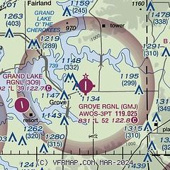
| Sectional chart |
|---|
|
| Airport distance calculator |
|---|
|
|
| Sunrise and sunset |
|---|
|
Times for 21-Jul-2026
| | Local
(UTC-5) | | Zulu
(UTC) |
|---|
| Morning civil twilight | | 05:48 | | 10:48 |
| Sunrise | | 06:17 | | 11:17 |
| Sunset | | 20:33 | | 01:33 |
| Evening civil twilight | | 21:03 | | 02:03 |
|
| Current date and time |
|---|
| Zulu (UTC) | 21-Jul-2026 11:34:25 |
|---|
| Local (UTC-5) | 21-Jul-2026 06:34:25 |
|---|
|
| METAR |
|---|
| KGMJ | 211115Z AUTO 00000KT 10SM 24/24 A2990 RMK AO2
|
KMIO
20nm N | 211115Z AUTO 00000KT 10SM CLR 25/23 A2989 RMK A01 TSNO
|
|
| TAF |
|---|
KXNA
29nm SE | 210541Z 2106/2206 24006KT P6SM SKC FM211800 35008KT P6SM FEW050 FM220200 02007KT P6SM SKC
|
KJLN
35nm N | 210520Z 2106/2206 19004KT P6SM SKC FM211500 27007KT P6SM FEW250 FM212200 01010G16KT P6SM SKC
|
KROG
35nm SE | 210541Z 2106/2206 23006KT P6SM SKC FM211800 35008KT P6SM FEW050 FM220200 03006KT P6SM SKC
|
|
| NOTAMs |
|---|
NOTAMs are issued by the DoD/FAA and will open in a separate window not controlled by AirNav.
|
|


