FAA INFORMATION EFFECTIVE 14 MAY 2026
Location
| FAA Identifier: | H04 |
| Lat/Long: | 36-36-52.6186N 095-09-06.1012W
36-36.876977N 095-09.101687W
36.6146163,-95.1516948
(estimated) |
| Elevation: | 695.2 ft. / 212 m (estimated) |
| Variation: | 05E (1985) |
| From city: | 2 miles SE of VINITA, OK |
| Time zone: | UTC -5 (UTC -6 during Standard Time) |
| Zip code: | 74301 |
Airport Operations
| Airport use: | Open to the public |
| Activation date: | 01/1965 |
| Control tower: | no |
| ARTCC: | KANSAS CITY CENTER |
| FSS: | MC ALESTER FLIGHT SERVICE STATION |
| NOTAMs facility: | MLC (NOTAM-D service available) |
| Attendance: | UNATNDD |
| Wind indicator: | lighted |
| Segmented circle: | yes |
| Lights: | ACTVT MIRL RWY 17/35 - CTAF. |
| Beacon: | white-green (lighted land airport)
Operates sunset to sunrise. |
Airport Communications
| CTAF: | 122.9 |
| WX AWOS-3PT at 1K8 (8 nm SE): | 118.150 (918-782-2047) |
| WX AWOS-3PT at GMJ (20 nm E): | 119.025 (918-786-8350) |
- APCH/DEP CTL SVC PRVDD BY KANSAS CITY ARTCC (ZKC) ON 128.6/282.325 (EDNA RCAG).
Nearby radio navigation aids
| VOR radial/distance | | VOR name | | Freq | | Var |
|---|
| TULr043/39.7 | | TULSA VORTAC | | 114.40 | | 08E |
Airport Services
| Fuel available: | 100LL
100LL:24/7 SELF SERVE 100LL AVAILABLE W/ CC |
| Parking: | tiedowns |
| Airframe service: | NONE |
| Powerplant service: | NONE |
| Bottled oxygen: | NONE |
| Bulk oxygen: | NONE |
Runway Information
Runway 17/35
| Dimensions: | 4209 x 60 ft. / 1283 x 18 m |
| Surface: | asphalt/concrete, in good condition |
| Runway edge lights: | medium intensity |
| RUNWAY 17 | | RUNWAY 35 |
| Latitude: | 36-37.223772N | | 36-36.530182N |
| Longitude: | 095-09.102705W | | 095-09.100667W |
| Elevation: | 695.2 ft. | | 678.6 ft. |
| Traffic pattern: | left | | left |
| Runway heading: | 174 magnetic, 179 true | | 354 magnetic, 359 true |
| Displaced threshold: | 210 ft. | | no |
| Markings: | basic, in good condition | | basic, in good condition |
| Visual slope indicator: | 2-light PAPI on left (3.00 degrees glide path) | | 2-light PAPI on left (3.00 degrees glide path) |
| Touchdown point: | yes, no lights | | yes, no lights |
| Obstructions: | 6 ft. fence, 228 ft. from runway, 4:1 slope to clear
RWY 17; 47 FT TREE 757 FT FM THLD, 120 FT RIGHT OF EXTDD CNTRLN. APCH SLOPE 20:1 TO DTHR. | | 30 ft. trees, 605 ft. from runway, 32 ft. left of centerline, 13:1 slope to clear |
Airport Ownership and Management from official FAA records
| Ownership: | Publicly-owned |
| Owner: | CITY OF VINITA
104 E. ILLINOIS, PO BOX 329
VINITA, OK 74301
Phone 918-256-6468 |
| Manager: | BRIAN PRINCE
747 E. AIRPORT ROAD, 104 E. ILLINOIS
VINITA, OK 74301
Phone 918-244-7260
DIRECTOR OF OPERATIONS. ARPT ATTENDANT: TERRY WILLIAMS 918-397-0193. |
Additional Remarks
| - | ULTRALIGHT ACTVTY ON & INVOF ARPT. |
| - | INTERSTATE HWY 425 FT NORTH OF RY 17 END. |
| - | FOR CD CTC KANSAS CITY ARTCC AT 913-254-8508. |
Instrument Procedures
NOTE: All procedures below are presented as PDF files. If you need a reader for these files, you should download the free Adobe Reader.NOT FOR NAVIGATION. Please procure official charts for flight.
FAA instrument procedures published for use from 14 May 2026 at 0901Z to 11 June 2026 at 0900Z.
IAPs - Instrument Approach Procedures |
|---|
| RNAV (GPS)-A | |
download (170KB) |
| NOTE: Special Take-Off Minimums/Departure Procedures apply | |
download (395KB) |
Other nearby airports with instrument procedures:
1K8 - South Grand Lake Regional Airport (8 nm SE)
KGMJ - Grove Regional Airport (20 nm E)
KMIO - Miami Regional Airport (22 nm NE)
H71 - Mid-America Industrial Airport (25 nm S)
KGCM - Claremore Regional Airport (25 nm SW)
|
|

Road maps at:
MapQuest
Bing
Google
| Aerial photo |
|---|
WARNING: Photo may not be current or correct
 Photo by Dean Ritter, Aerial Oklahoma
Do you have a better or more recent aerial photo of Vinita Municipal Airport that you would like to share? If so, please send us your photo.
|
| Sectional chart |
|---|
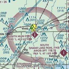
|
| Airport distance calculator |
|---|
|
|
| Sunrise and sunset |
|---|
|
Times for 10-Jun-2026
| | Local
(UTC-5) | | Zulu
(UTC) |
|---|
| Morning civil twilight | | 05:32 | | 10:32 |
| Sunrise | | 06:03 | | 11:03 |
| Sunset | | 20:37 | | 01:37 |
| Evening civil twilight | | 21:08 | | 02:08 |
|
| Current date and time |
|---|
| Zulu (UTC) | 10-Jun-2026 06:21:45 |
|---|
| Local (UTC-5) | 10-Jun-2026 01:21:45 |
|---|
|
| METAR |
|---|
KGMJ
20nm E | 100555Z AUTO 19009KT 10SM CLR 25/22 A2993 RMK AO2
|
KMIO
22nm NE | 100555Z AUTO 18012G18KT 10SM CLR 26/24 A2991 RMK A01
|
KGCM
25nm SW | 100555Z AUTO 16008G14KT 10SM CLR 25/25 A2992 RMK AO2
|
KCFV
34nm NW | 100552Z AUTO 19013G18KT 10SM CLR 26/22 A2988 RMK AO2 SLP111 T02610217 10306 20261 403170228 50004
|
|
| TAF |
|---|
KBVO
43nm W | 100520Z 1006/1106 18009G18KT P6SM FEW025 SCT100 BKN150 WS020/20040KT FM101500 19015G24KT P6SM FEW035 SCT060 SCT180 FM110200 18011G20KT P6SM FEW040 SCT120
|
KTUL
43nm SW | 100520Z 1006/1106 18014G21KT P6SM FEW030 SCT120 SCT150 WS020/20040KT FM101300 19017G25KT P6SM FEW025 SCT060 SCT180 FM101800 19020G30KT P6SM FEW040 SCT150 SCT250 FM110300 17016G23KT P6SM FEW120
|
KJLN
45nm NE | 100520Z 1006/1106 19012G20KT P6SM FEW250 FM101100 20013G22KT P6SM SCT250 FM101400 21017G26KT P6SM SCT220 FM110000 20014G23KT P6SM SKC FM110200 19012KT P6SM FEW230
|
KXNA
46nm SE | 100520Z 1006/1106 19008KT P6SM FEW250 FM101300 20015G23KT P6SM SCT020 BKN100 FM101700 20018G28KT P6SM FEW030 SCT120 SCT250 FM110200 18012KT P6SM SCT040 SCT120
|
|
| NOTAMs |
|---|
NOTAMs are issued by the DoD/FAA and will open in a separate window not controlled by AirNav.
|
|

