FAA INFORMATION EFFECTIVE 11 JUNE 2026
Location
| FAA Identifier: | HAO |
| Lat/Long: | 39-21-49.5000N 084-31-19.0000W
39-21.825000N 084-31.316667W
39.3637500,-84.5219444
(estimated) |
| Elevation: | 631.8 ft. / 192.6 m (surveyed) |
| Variation: | 06W (2025) |
| From city: | 3 miles SE of HAMILTON, OH |
| Time zone: | UTC -4 (UTC -5 during Standard Time) |
| Zip code: | 45015 |
Airport Operations
| Airport use: | Open to the public |
| Activation date: | 12/1937 |
| Control tower: | no |
| ARTCC: | INDIANAPOLIS CENTER |
| FSS: | DAYTON FLIGHT SERVICE STATION |
| NOTAMs facility: | HAO (NOTAM-D service available) |
| Attendance: | NOV-MAR 0700-2100, APR-OCT 0700-2200 |
| Wind indicator: | lighted |
| Segmented circle: | no |
| Lights: | ACTVT MALS RWY 30; REIL RWY 12 & 30; PAPI RWY 12 & 30; MIRL RWY 12/30 - CTAF. |
| Beacon: | white-green (lighted land airport)
Operates sunset to sunrise. |
Airport Communications
| CTAF/UNICOM: | 123.05 |
| WX ASOS: | 121.425 (513-863-6137) |
| CINCINNATI APPROACH: | 121.0 |
| CINCINNATI DEPARTURE: | 121.0 |
| CLEARANCE DELIVERY: | 126.25 |
| WX AWOS-3PT at MWO (12 nm NE): | 120.025 (513-422-3505) |
| WX AWOS-3PT at I67 (13 nm SW): | 118.15 (513-569-4964) |
| WX AWOS-3PT at I68 (14 nm NE): | 120.55 (513-934-5500) |
| WX AWOS-3PT at OXD (15 nm NW): | 118.625 (513-273-2032) |
| WX ASOS at LUK (16 nm S): | PHONE 513-321-6291 |
| WX ASOS at MGY (19 nm NE): | 118.375 (937-885-2171) |
Nearby radio navigation aids
| VOR radial/distance | | VOR name | | Freq | | Var |
|---|
| MXQr267/33.6 | | MIDWEST VOR/DME | | 112.90 | | 04W |
| DQNr189/39.6 | | DAYTON VOR/DME | | 114.50 | | 01W |
| NDB name | | Hdg/Dist | | Freq | | Var | | ID |
|---|
| SPORTYS | | 324/22.4 | | 245 | | 04W | | PWF | .--. .-- ..-. |
Airport Services
| Fuel available: | 100LL JET-A JET-A+
A+:JET A+ AVBL ON REQ AT DLVY. |
| Parking: | hangars and tiedowns |
| Airframe service: | MAJOR |
| Powerplant service: | MAJOR |
| Bottled oxygen: | LOW |
| Bulk oxygen: | NONE |
Runway Information
Runway 12/30
| Dimensions: | 5500 x 100 ft. / 1676 x 30 m |
| Surface: | asphalt/grooved, in good condition |
| Weight bearing capacity: | | Single wheel: | 60.0 | | Double wheel: | 75.0 | | Double tandem: | 75.0 |
|
| Runway edge lights: | medium intensity |
| RUNWAY 12 | | RUNWAY 30 |
| Latitude: | 39-21.983263N | | 39-21.667883N |
| Longitude: | 084-31.863653W | | 084-30.769597W |
| Elevation: | 631.8 ft. | | 618.9 ft. |
| Traffic pattern: | left | | left |
| Runway heading: | 116 magnetic, 110 true | | 296 magnetic, 290 true |
| Markings: | nonprecision, in good condition | | precision, in good condition |
| Visual slope indicator: | 4-light PAPI on left (3.50 degrees glide path) | | 4-light PAPI on left (3.00 degrees glide path) |
| Approach lights: | | | MALS: 1,400 foot medium intensity approach lighting system |
| Runway end identifier lights: | yes | | yes |
| Touchdown point: | yes, no lights | | yes, no lights |
| Instrument approach: | | | ILS/DME |
| Obstructions: | 137 ft. trees, lighted, 2520 ft. from runway, 537 ft. right of centerline, 16:1 slope to clear
+3-9 FT BRUSH, 0-200 FT DIST, 190-415 FT L. | | 25 ft. trees, 382 ft. from runway, 434 ft. right of centerline, 7:1 slope to clear |
Airport Ownership and Management from official FAA records
| Ownership: | Publicly-owned |
| Owner: | BUTLER COUNTY BD OF COMMISSIONERS
130 HIGH ST
HAMILTON, OH 45011-2750
Phone 513-887-3412 |
| Manager: | JERRY RICHARDSON
7802 E AIRPORT RD
HAMILTON, OH 45015
Phone 513-785-5444 |
Additional Remarks
| - | FOR CD CTC CINCINNATI APCH AT 859-372-6440. |
| - | DEER, BIRDS, & OTR WILDLIFE ON & INVOF ARPT. |
Instrument Procedures
NOTE: All procedures below are presented as PDF files. If you need a reader for these files, you should download the free Adobe Reader.NOT FOR NAVIGATION. Please procure official charts for flight.
FAA instrument procedures published for use from 11 June 2026 at 0901Z to 09 July 2026 at 0900z.
STARs - Standard Terminal Arrivals |
|---|
| CEGRM EIGHT (RNAV) **NEW** | |
2 pages:
[1] [2] (316KB) |
| CEGRM EIGHT (RNAV), CONT.2 **NEW** | |
download (214KB) |
| GAVNN EIGHT (RNAV) **NEW** | |
2 pages:
[1] [2] (461KB) |
| HEDEE ONE (RNAV) **NEW** | |
download (116KB) |
| JAKIE SEVEN (RNAV) **NEW** | |
2 pages:
[1] [2] (297KB) |
| JAKIE SEVEN (RNAV), CONT.2 **NEW** | |
download (242KB) |
| SARGO FIVE (RNAV) **NEW** | |
2 pages:
[1] [2] (453KB) |
IAPs - Instrument Approach Procedures |
|---|
| ILS OR LOC RWY 30 | |
download (220KB) |
| RNAV (GPS) RWY 12 | |
download (203KB) |
| RNAV (GPS) RWY 30 | |
download (203KB) |
| NOTE: Special Alternate Minimums apply | |
download (169KB) |
| NOTE: Special Take-Off Minimums/Departure Procedures apply | |
download (479KB) |
Other nearby airports with instrument procedures:
KMWO - Middletown Regional Airport/Hook Field (12 nm NE)
I67 - Cincinnati West Airport (13 nm SW)
I68 - Warren County Airport/John Lane Field (14 nm NE)
KOXD - Miami University Airport (15 nm NW)
KLUK - Cincinnati Municipal Airport/Lunken Field (16 nm S)
KMGY - Dayton/Wright Brothers Airport (19 nm NE)
|
|

Road maps at:
MapQuest
Bing
Google
| Aerial photo |
|---|
WARNING: Photo may not be current or correct
 Photo by Daniel Betts
Photo taken 02-Apr-2012
looking north.
Photo by Daniel Betts
Photo taken 02-Apr-2012
looking north.
Do you have a better or more recent aerial photo of Butler County Regional Airport/Hogan Field that you would like to share? If so, please send us your photo.
|
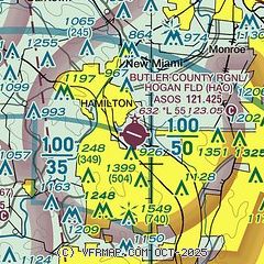
| Sectional chart |
|---|
|
CAUTION: Diagram may not be current

| Airport distance calculator |
|---|
|
|
| Sunrise and sunset |
|---|
|
Times for 17-Jun-2026
| | Local
(UTC-4) | | Zulu
(UTC) |
|---|
| Morning civil twilight | | 05:39 | | 09:39 |
| Sunrise | | 06:12 | | 10:12 |
| Sunset | | 21:06 | | 01:06 |
| Evening civil twilight | | 21:39 | | 01:39 |
|
| Current date and time |
|---|
| Zulu (UTC) | 17-Jun-2026 10:36:12 |
|---|
| Local (UTC-4) | 17-Jun-2026 06:36:12 |
|---|
|
| METAR |
|---|
| KHAO | 171014Z AUTO 00000KT 4SM BR CLR 13/13 A2977 RMK AO2 T01280128
|
KMWO
12nm NE | 171015Z AUTO 24003KT 1SM BR VV007 12/12 A2977 RMK AO2 VIS 1/4V5
|
KI67
13nm SW | 170915Z AUTO 17003KT 10SM CLR 15/14 A2975 RMK AO1
|
KI68
14nm NE | 171015Z AUTO 00000KT 10SM CLR 14/14 A2975 RMK AO2
|
KOXD
15nm NW | 171015Z AUTO 24004KT 10SM CLR 15/14 A2976 RMK AO2 T01450140
|
KLUK
17nm S | 171007Z AUTO 19004KT 3SM R21/1200V2200FT BR BKN080 14/14 A2977 RMK AO2 T01390139
|
KMGY
19nm NE | 170953Z AUTO 21003KT 10SM CLR 15/13 A2975 RMK AO2 SLP068 T01500128
|
KCVG
20nm S | 170952Z 20004KT 6SM BR FEW075 SCT250 14/13 A2977 RMK AO2 SLP074 T01390133 $
|
|
| TAF |
|---|
KLUK
17nm S | 170954Z 1710/1806 19005KT 4SM BR SCT250 TEMPO 1710/1712 2SM BR FM171200 19010KT P6SM BKN250 FM171800 20014G20KT P6SM SCT050 FM172300 20020G30KT P6SM BKN080 FM180400 22018G28KT P6SM -SHRA BKN060 WS020/22050KT TEMPO 1805/1806 2SM -TSRA OVC025CB
|
KCVG
20nm S | 170857Z 1709/1812 20008KT P6SM SCT060 FM171400 19010KT P6SM BKN250 FM171800 20014G20KT P6SM SCT050 FM172300 20020G30KT P6SM BKN080 FM180400 22018G28KT P6SM -SHRA BKN060 WS020/22050KT TEMPO 1805/1808 2SM -TSRA OVC025CB FM180900 24014G24KT P6SM BKN025
|
|
| NOTAMs |
|---|
NOTAMs are issued by the DoD/FAA and will open in a separate window not controlled by AirNav.
|
|


