FAA INFORMATION EFFECTIVE 14 MAY 2026
Location
| FAA Identifier: | OXD |
| Lat/Long: | 39-30-08.1350N 084-47-03.7730W
39-30.135583N 084-47.062883W
39.5022597,-84.7843814
(estimated) |
| Elevation: | 1040.7 ft. / 317.2 m (surveyed) |
| Variation: | 04W (1995) |
| From city: | 2 miles W of OXFORD, OH |
| Time zone: | UTC -4 (UTC -5 during Standard Time) |
| Zip code: | 45056 |
Airport Operations
| Airport use: | Open to the public |
| Activation date: | 02/1940 |
| Control tower: | no |
| ARTCC: | INDIANAPOLIS CENTER |
| FSS: | DAYTON FLIGHT SERVICE STATION |
| NOTAMs facility: | OXD (NOTAM-D service available) |
| Attendance: | UNATNDD |
| Wind indicator: | lighted |
| Segmented circle: | no |
| Lights: | ACTVT OR INCR INTST REIL RWY 05 & 23; MIRL RWY 05/23 - 122.9. PAPI RWY 05 & 23 OPR CONSLY; MIRL RWY 05/23 PRESET LOW INTST DUSK-2100. |
| Beacon: | white-green (lighted land airport)
Operates sunset to sunrise. |
Airport Communications
| CTAF/UNICOM: | 122.8 |
| WX AWOS-3PT: | 118.625 (513-273-2032) |
| CINCINNATI APPROACH: | 121.0 |
| CINCINNATI DEPARTURE: | 121.0 |
| WX AWOS-3PT at I67 (15 nm S): | 118.15 (513-569-4964) |
| WX ASOS at HAO (15 nm SE): | 121.425 (513-863-6137) |
| WX AWOS-3 at RID (15 nm N): | 121.225 (765-983-1903) |
| WX AWOS-3PT at MWO (18 nm E): | 120.025 (513-422-3505) |
| WX AWOS-3 at CEV (20 nm NW): | 118.325 (765-827-6649) |
Nearby radio navigation aids
| VOR radial/distance | | VOR name | | Freq | | Var |
|---|
| DQNr211/35.7 | | DAYTON VOR/DME | | 114.50 | | 01W |
| NDB name | | Hdg/Dist | | Freq | | Var | | ID |
|---|
| NEW CASTLE | | 139/33.5 | | 385 | | 06W | | UWL | ..- .-- .-.. |
| SPORTYS | | 318/36.7 | | 245 | | 04W | | PWF | .--. .-- ..-. |
Airport Services
| Fuel available: | 100LL JET-A1+
100LL:100LL AVBL H24 SELF SVC VIA CREDIT CARD.
A1+:JET A AVBL FULL SER ONLY ON RQ. CALL ARPT MGR FOR SER. |
| Parking: | hangars and tiedowns |
| Airframe service: | MINOR |
| Powerplant service: | MINOR |
| Bottled oxygen: | NONE |
| Bulk oxygen: | NONE |
Runway Information
Runway 5/23
| Dimensions: | 4011 x 70 ft. / 1223 x 21 m |
| Surface: | asphalt, in good condition |
| Weight bearing capacity: | | Single wheel: | 34.0 | | Double wheel: | 50.0 |
|
| Runway edge lights: | medium intensity |
| RUNWAY 5 | | RUNWAY 23 |
| Latitude: | 39-29.904370N | | 39-30.366798N |
| Longitude: | 084-47.367397W | | 084-46.758325W |
| Elevation: | 1040.3 ft. | | 1034.3 ft. |
| Traffic pattern: | left | | left |
| Runway heading: | 050 magnetic, 046 true | | 230 magnetic, 226 true |
| Displaced threshold: | 270 ft. | | no |
| Markings: | nonprecision, in good condition | | nonprecision, in good condition |
| Visual slope indicator: | 2-light PAPI on left (3.00 degrees glide path) | | 2-light PAPI on left (3.00 degrees glide path) |
| Runway end identifier lights: | yes | | yes |
| Touchdown point: | yes, no lights | | yes, no lights |
| Obstructions: | 10 ft. road, 201 ft. from runway, 130 ft. left of centerline, 1:1 slope to clear
5 FT FENCE & 10 FT ROAD, 75-200 FT DIST, 130-250 FT L. | | 12 ft. trees, 361 ft. from runway, 254 ft. left of centerline, 13:1 slope to clear |
Airport Ownership and Management from official FAA records
| Ownership: | Publicly-owned |
| Owner: | MIAMI UNIVERSITY
MIAMI UNIVERSITY ARPT, 7101 FAIRFIELD RD
OXFORD, OH 45056-9776
Phone 513-529-2735 |
| Manager: | SCOTT SMITH
7101 FAIRFIELD RD
OXFORD, OH 45056-9776
Phone 513-330-1502 |
Additional Remarks
| - | FOR CD CTC CINCINNATI APCH AT 859-372-6440. |
Instrument Procedures
NOTE: All procedures below are presented as PDF files. If you need a reader for these files, you should download the free Adobe Reader.NOT FOR NAVIGATION. Please procure official charts for flight.
FAA instrument procedures published for use from 14 May 2026 at 0901Z to 11 June 2026 at 0900Z.
IAPs - Instrument Approach Procedures |
|---|
| RNAV (GPS) RWY 05 | |
download (248KB) |
| RNAV (GPS) RWY 23 | |
download (249KB) |
| NOTE: Special Alternate Minimums apply | |
download (151KB) |
| NOTE: Special Take-Off Minimums/Departure Procedures apply | |
download (487KB) |
Other nearby airports with instrument procedures:
I67 - Cincinnati West Airport (15 nm S)
KHAO - Butler County Regional Airport/Hogan Field (15 nm SE)
KRID - Richmond Municipal Airport (15 nm N)
KMWO - Middletown Regional Airport/Hook Field (18 nm E)
KCEV - Mettel Field Airport (20 nm NW)
|
|

Road maps at:
MapQuest
Bing
Google
| Aerial photo |
|---|
WARNING: Photo may not be current or correct
 Photo taken 23-Sep-2014
looking north.
Photo taken 23-Sep-2014
looking north.
Do you have a better or more recent aerial photo of Miami University Airport that you would like to share? If so, please send us your photo.
|
| Sectional chart |
|---|
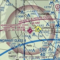
|
| Airport distance calculator |
|---|
|
|
| Sunrise and sunset |
|---|
|
Times for 31-May-2026
| | Local
(UTC-4) | | Zulu
(UTC) |
|---|
| Morning civil twilight | | 05:44 | | 09:44 |
| Sunrise | | 06:15 | | 10:15 |
| Sunset | | 20:58 | | 00:58 |
| Evening civil twilight | | 21:30 | | 01:30 |
|
| Current date and time |
|---|
| Zulu (UTC) | 31-May-2026 12:45:05 |
|---|
| Local (UTC-4) | 31-May-2026 08:45:05 |
|---|
|
| METAR |
|---|
| KOXD | 311235Z AUTO 09006KT 10SM CLR 14/09 A3010 RMK AO2 T01400090
|
KI67
15nm S | 311235Z AUTO 04003KT 10SM CLR 13/10 A3010 RMK AO1
|
KHAO
15nm SE | 311153Z AUTO 06004KT 10SM CLR 14/09 A3012 RMK AO2 SLP196 T01390089 10150 20083 58000
|
KRID
15nm N | 311235Z AUTO 09008KT 10SM CLR 14/08 A3011 RMK AO2
|
KMWO
18nm E | 311235Z AUTO 05006KT 10SM CLR 15/10 A3011 RMK AO2
|
|
| TAF |
|---|
KCVG
28nm S | 311120Z 3112/0118 08007KT P6SM BKN250 FM312200 VRB04KT P6SM SCT100 BKN200 FM011500 06008KT P6SM SCT100 BKN200
|
KLUK
30nm SE | 311120Z 3112/0112 09005KT P6SM BKN250 FM312200 VRB02KT P6SM SCT100 BKN200
|
|
| NOTAMs |
|---|
NOTAMs are issued by the DoD/FAA and will open in a separate window not controlled by AirNav.
|
|


