FAA INFORMATION EFFECTIVE 09 JULY 2026
Location
| FAA Identifier: | RID |
| Lat/Long: | 39-45-21.9000N 084-50-33.7000W
39-45.365000N 084-50.561667W
39.7560833,-84.8426944
(estimated) |
| Elevation: | 1139.8 ft. / 347.4 m (surveyed) |
| Variation: | 03W (1985) |
| From city: | 5 miles SE of RICHMOND, IN |
| Time zone: | UTC -4 (UTC -5 during Standard Time) |
| Zip code: | 47374 |
Airport Operations
| Airport use: | Open to the public |
| Activation date: | 12/1944 |
| Control tower: | no |
| ARTCC: | INDIANAPOLIS CENTER |
| FSS: | TERRE HAUTE FLIGHT SERVICE STATION |
| NOTAMs facility: | HUF (NOTAM-D service available) |
| Attendance: | 0800-1745 |
| Wind indicator: | lighted |
| Segmented circle: | no |
| Lights: | ACTVT REIL RWY 06; PAPI RWY 06 & 24; MIRL RWY 06/24 & RWY 15/33 - CTAF. |
| Beacon: | white-green (lighted land airport)
Operates sunset to sunrise. |
Airport Communications
| CTAF/UNICOM: | 122.7 |
| WX AWOS-3: | 121.225 (765-983-1903) |
| COLUMBUS APPROACH: | 134.45 [1230-0400Z++] |
| COLUMBUS DEPARTURE: | 134.45 [1230-0400Z++] |
| CLEARANCE DELIVERY: | 133.55 |
| WX AWOS-3 at CEV (14 nm W): | 118.325 (765-827-6649) |
| WX AWOS-3PT at OXD (15 nm S): | 118.625 (513-273-2032) |
Nearby radio navigation aids
| VOR radial/distance | | VOR name | | Freq | | Var |
|---|
| DQNr234/25.8 | | DAYTON VOR/DME | | 114.50 | | 01W |
| NDB name | | Hdg/Dist | | Freq | | Var | | ID |
|---|
| PNTHR | | 099/13.3 | | 227 | | 04W | | SQ | ... --.- |
| NEW CASTLE | | 115/23.2 | | 385 | | 06W | | UWL | ..- .-- .-.. |
Airport Services
| Fuel available: | 100LL JET-A |
| Parking: | hangars and tiedowns |
| Airframe service: | MINOR |
| Powerplant service: | MINOR |
Runway Information
Runway 6/24
| Dimensions: | 5502 x 150 ft. / 1677 x 46 m |
| Surface: | asphalt/grooved, in excellent condition |
| Weight bearing capacity: | | Single wheel: | 30.0 | | Double wheel: | 40.0 | | Double tandem: | 60.0 |
|
| Runway edge lights: | medium intensity |
| RUNWAY 6 | | RUNWAY 24 |
| Latitude: | 39-45.098590N | | 39-45.616303N |
| Longitude: | 084-51.005935W | | 084-50.042418W |
| Elevation: | 1134.7 ft. | | 1138.2 ft. |
| Traffic pattern: | left | | left |
| Runway heading: | 058 magnetic, 055 true | | 238 magnetic, 235 true |
| Displaced threshold: | 300 ft. | | no |
| Declared distances: | TORA:5500 TODA:5500 ASDA:5500 LDA:5200 | | TORA:5500 TODA:5500 ASDA:5500 LDA:5500 |
| Markings: | precision, in good condition | | precision, in good condition |
| Visual slope indicator: | 4-light PAPI on left (3.00 degrees glide path) | | 4-light PAPI on left (3.00 degrees glide path) |
| Runway end identifier lights: | yes | | no |
| Touchdown point: | yes, no lights | | yes, no lights |
| Instrument approach: | | | LOC/GS |
| Obstructions: | 18 ft. road, 320 ft. from runway, 510 ft. left of centerline, 6:1 slope to clear
APCH RATIO 34:1 TO DTHR. | | 72 ft. trees, 1740 ft. from runway, 730 ft. right of centerline, 21:1 slope to clear
APCH RATIO 24:1 TO THR. |
Runway 15/33
| Dimensions: | 4999 x 100 ft. / 1524 x 30 m |
| Surface: | asphalt, in fair condition |
| Weight bearing capacity: | | Single wheel: | 30.0 | | Double wheel: | 40.0 | | Double tandem: | 60.0 |
|
| Runway edge lights: | medium intensity |
| RUNWAY 15 | | RUNWAY 33 |
| Latitude: | 39-45.712193N | | 39-45.036672N |
| Longitude: | 084-50.909478W | | 084-50.299737W |
| Elevation: | 1126.7 ft. | | 1139.8 ft. |
| Traffic pattern: | left | | left |
| Runway heading: | 148 magnetic, 145 true | | 328 magnetic, 325 true |
| Markings: | nonprecision, in good condition | | nonprecision, in good condition |
| Touchdown point: | yes, no lights | | yes, no lights |
| Obstructions: | none
10 FT CROPS 105 FT L OF RWY END CNTRLN. | | 66 ft. trees, 2550 ft. from runway, 15 ft. left of centerline, 35:1 slope to clear
10 FT CROPS 100 FT L & R OF RWY END CNTRLN. |
Airport Ownership and Management from official FAA records
| Ownership: | Publicly-owned |
| Owner: | RICHMOND BOAC
5169 SR 227 S.
RICHMOND, IN 47375
Phone 765-983-7296 |
| Manager: | RODNEY MAYSE
5169 SR 227 S.
RICHMOND, IN 47374
Phone 765-983-7296
AFT HR 765-993-4139. |
Instrument Procedures
NOTE: All procedures below are presented as PDF files. If you need a reader for these files, you should download the free Adobe Reader.NOT FOR NAVIGATION. Please procure official charts for flight.
FAA instrument procedures published for use from 09 July 2026 at 0901Z to 06 August 2026 at 0900Z.
IAPs - Instrument Approach Procedures |
|---|
| RNAV (GPS) RWY 06 **CHANGED** | |
download (207KB) |
| RNAV (GPS) RWY 24 **CHANGED** | |
download (203KB) |
| RNAV (GPS) RWY 33 **CHANGED** | |
download (191KB) |
| NOTE: Special Take-Off Minimums/Departure Procedures apply | |
download (482KB) |
Other nearby airports with instrument procedures:
KCEV - Mettel Field Airport (14 nm W)
KOXD - Miami University Airport (15 nm S)
3I7 - Dayton/Phillipsburg Airport (22 nm NE)
KUWL - New Castle Henry County Airport / Marlatt Field (23 nm W)
KMWO - Middletown Regional Airport/Hook Field (25 nm SE)
|
|

Road maps at:
MapQuest
Bing
Google
| Aerial photo |
|---|
WARNING: Photo may not be current or correct
 Photo courtesy of MetroFlyer, LLC www.metroflyer.com
Taken in January 2008
Photo courtesy of MetroFlyer, LLC www.metroflyer.com
Taken in January 2008
Do you have a better or more recent aerial photo of Richmond Municipal Airport that you would like to share? If so, please send us your photo.
|
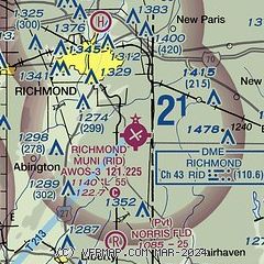
| Sectional chart |
|---|
|
| Airport distance calculator |
|---|
|
|
| Sunrise and sunset |
|---|
|
Times for 13-Jul-2026
| | Local
(UTC-4) | | Zulu
(UTC) |
|---|
| Morning civil twilight | | 05:52 | | 09:52 |
| Sunrise | | 06:23 | | 10:23 |
| Sunset | | 21:07 | | 01:07 |
| Evening civil twilight | | 21:39 | | 01:39 |
|
| Current date and time |
|---|
| Zulu (UTC) | 13-Jul-2026 20:42:07 |
|---|
| Local (UTC-4) | 13-Jul-2026 16:42:07 |
|---|
|
| METAR |
|---|
| KRID | 132015Z AUTO 02006KT 10SM SCT038 29/21 A3017 RMK AO2
|
KOXD
15nm S | 132015Z AUTO 07006KT 10SM SCT034 SCT100 29/22 A3015 RMK AO2 T02930215
|
|
| TAF |
|---|
KDAY
30nm E | 131721Z 1318/1418 05007KT P6SM FEW250 FM140100 VRB04KT P6SM SKC
|
KFFO
37nm E | 131900Z 1319/1501 05009KT 9999 SCT037 SCT250 QNH3010INS BECMG 1322/1323 VRB06KT 9999 FEW250 QNH3011INS BECMG 1415/1416 12006KT 9999 FEW040 SCT250 QNH3009INS TX31/1320Z TN19/1411Z
|
|
| NOTAMs |
|---|
NOTAMs are issued by the DoD/FAA and will open in a separate window not controlled by AirNav.
|
|

