FAA INFORMATION EFFECTIVE 16 APRIL 2026
Location
| FAA Identifier: | LUX |
| Lat/Long: | 34-30-25.6000N 081-56-49.0000W
34-30.426667N 081-56.816667W
34.5071111,-81.9469444
(estimated) |
| Elevation: | 697.6 ft. / 212.6 m (surveyed) |
| Variation: | 07W (2015) |
| From city: | 3 miles E of LAURENS, SC |
| Time zone: | UTC -4 (UTC -5 during Standard Time) |
| Zip code: | 29360 |
Airport Operations
| Airport use: | Open to the public |
| Activation date: | 11/1963 |
| Control tower: | no |
| ARTCC: | ATLANTA CENTER |
| FSS: | ANDERSON FLIGHT SERVICE STATION |
| NOTAMs facility: | AND (NOTAM-D service available) |
| Attendance: | MON-SAT 0900-1700, ALL SUN 1300-1700 |
| Pattern altitude: | 1500.6 ft. MSL
TPA: 803 FT AGL. |
| Wind indicator: | lighted |
| Segmented circle: | yes |
| Lights: | ACTVT REIL RWY 08 & 26; MIRL RWY 08/26 - CTAF. PAPI RWY 08 & 26 OPR CONSLY. |
| Beacon: | white-green (lighted land airport)
Operates sunset to sunrise. |
Airport Communications
| CTAF/UNICOM: | 122.8 |
| WX AWOS-3: | 123.975 (864-682-3639) |
| GREER APPROACH: | 120.6 |
| GREER DEPARTURE: | 120.6 |
| WX AWOS-3PT at 35A (19 nm NE): | 119.45 (864-427-1514) |
| WX ASOS at GRD (19 nm SW): | 121.125 (864-388-9115) |
| WX AWOS-3 at EOE (19 nm SE): | 124.275 (803-276-2419) |
- APCH/DEP SVC PRVDD BY ATLANTA ARTCC ON FREQS 135.35/263.125 (OWING RCAG) WHEN GREER APCH CTL CLSD.
Nearby radio navigation aids
| VOR radial/distance | | VOR name | | Freq | | Var |
|---|
| SPAr184/31.6 | | SPARTANBURG VORTAC | | 115.70 | | 02W |
| NDB name | | Hdg/Dist | | Freq | | Var | | ID |
|---|
| UNION COUNTY | | 241/18.4 | | 326 | | 06W | | UOT | ..- --- - |
Airport Services
| Fuel available: | 100LL
100LL:SELF SVC 24 HR FUEL WITH CREDIT CARD. |
| Parking: | tiedowns |
| Airframe service: | MAJOR |
| Powerplant service: | MAJOR |
| Bottled oxygen: | NONE |
| Bulk oxygen: | NONE |
Runway Information
Runway 8/26
| Dimensions: | 4051 x 75 ft. / 1235 x 23 m |
| Surface: | concrete, in excellent condition |
| Weight bearing capacity: | |
| Runway edge lights: | medium intensity |
| RUNWAY 8 | | RUNWAY 26 |
| Latitude: | 34-30.325628N | | 34-30.527625N |
| Longitude: | 081-57.201332W | | 081-56.432455W |
| Elevation: | 697.2 ft. | | 693.1 ft. |
| Traffic pattern: | left | | left |
| Runway heading: | 079 magnetic, 072 true | | 259 magnetic, 252 true |
| Markings: | nonprecision, in good condition | | nonprecision, in good condition |
| Visual slope indicator: | 2-light PAPI on left (3.00 degrees glide path) | | 2-light PAPI on left (3.25 degrees glide path) |
| Runway end identifier lights: | yes | | yes |
| Touchdown point: | yes, no lights | | yes, no lights |
| Obstructions: | 52 ft. tree, 1002 ft. from runway, 113 ft. left of centerline, 15:1 slope to clear | | 56 ft. tree, 1059 ft. from runway, 144 ft. right of centerline, 15:1 slope to clear |
Airport Ownership and Management from official FAA records
| Ownership: | Publicly-owned |
| Owner: | LAURENS COUNTY
606 SOUTH ADAIR STREET
CLINTON, SC 29360
Phone (864) 833-4304 |
| Manager: | GIFFORD A. BOYTER
3985 TORRINGTON ROAD
LAURENS, SC 29360
Phone (864) 923-3507 |
Additional Remarks
| - | FOR CD CTC GREER APCH AT 864-877-8275. WHEN GREER APCH CLSD, FOR CD CTC ATLANTA ARTCC AT 770-210-7692. |
Instrument Procedures
NOTE: All procedures below are presented as PDF files. If you need a reader for these files, you should download the free Adobe Reader.NOT FOR NAVIGATION. Please procure official charts for flight.
FAA instrument procedures published for use from 16 April 2026 at 0901Z to 14 May 2026 at 0900Z.
IAPs - Instrument Approach Procedures |
|---|
| RNAV (GPS) RWY 08 | |
download (229KB) |
| RNAV (GPS) RWY 26 | |
download (206KB) |
| NOTE: Special Take-Off Minimums/Departure Procedures apply | |
download (141KB) |
Other nearby airports with instrument procedures:
35A - Union County Airport, Troy Shelton Field (19 nm NE)
KGRD - Greenwood County Airport (19 nm SW)
KEOE - Newberry County Airport (19 nm SE)
KSPA - Spartanburg Downtown Memorial Airport/Simpson Field (25 nm N)
KGYH - Donaldson Field Airport (26 nm NW)
|
|

Road maps at:
MapQuest
Bing
Google
| Aerial photo |
|---|
WARNING: Photo may not be current or correct
 Photo by Jim Austin
Photo taken 08-Dec-2012
looking north.
Photo by Jim Austin
Photo taken 08-Dec-2012
looking north.
Do you have a better or more recent aerial photo of Laurens County Airport that you would like to share? If so, please send us your photo.
|
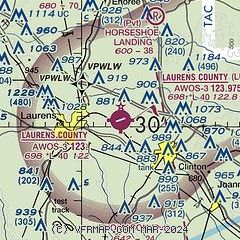
| Sectional chart |
|---|
|
| Airport distance calculator |
|---|
|
|
| Sunrise and sunset |
|---|
|
Times for 12-May-2026
| | Local
(UTC-4) | | Zulu
(UTC) |
|---|
| Morning civil twilight | | 06:01 | | 10:01 |
| Sunrise | | 06:29 | | 10:29 |
| Sunset | | 20:20 | | 00:20 |
| Evening civil twilight | | 20:47 | | 00:47 |
|
| Current date and time |
|---|
| Zulu (UTC) | 12-May-2026 15:14:38 |
|---|
| Local (UTC-4) | 12-May-2026 11:14:38 |
|---|
|
| METAR |
|---|
| KLUX | 121435Z AUTO 00000KT 10SM CLR 15/07 A3026 RMK AO2
|
KGRD
18nm SW | 121356Z AUTO 04006KT 10SM OVC060 16/09 A3025 RMK AO2 SLP241 T01560094
|
KEOE
19nm SE | 121435Z AUTO 06004KT 10SM CLR 16/07 A3028 RMK AO2
|
|
| TAF |
|---|
KGSP
27nm NW | 121139Z 1212/1312 05007KT P6SM SCT060 BKN250 FM121800 13006KT P6SM FEW250 FM130100 VRB03KT P6SM SKC
|
KGMU
29nm NW | 121139Z 1212/1312 06008KT P6SM SCT060 BKN250 FM121800 13006KT P6SM FEW250 FM130200 VRB03KT P6SM SKC
|
|
| NOTAMs |
|---|
NOTAMs are issued by the DoD/FAA and will open in a separate window not controlled by AirNav.
|
|

