FAA INFORMATION EFFECTIVE 19 MARCH 2026
Location
| FAA Identifier: | ONX |
| Lat/Long: | 36-23-59.7880N 076-00-55.5310W
36-23.996467N 076-00.925517W
36.3999411,-76.0154253
(estimated) |
| Elevation: | 17.7 ft. / 5.4 m (surveyed) |
| Variation: | 10W (1995) |
| From city: | 4 miles S of CURRITUCK, NC |
| Time zone: | UTC -4 (UTC -5 during Standard Time) |
| Zip code: | 27956 |
Airport Operations
| Airport use: | Open to the public |
| Activation date: | 06/1976 |
| Control tower: | no |
| ARTCC: | WASHINGTON CENTER |
| FSS: | RALEIGH FLIGHT SERVICE STATION |
| NOTAMs facility: | ONX (NOTAM-D service available) |
| Attendance: | 0800-1600
UNATNDD ON ALL STATE HOLIDAYS.
AFTER HRS SVC CALL 252-232-6101. |
| Wind indicator: | lighted |
| Segmented circle: | yes |
| Lights: | ACTVT REIL RWY 05 & 23; MIRL RWY 05/23 AFT SS - CTAF. PAPI RWY 05 & 23 ON CONSLY; TO INCR INTST - CTAF. |
| Beacon: | white-green (lighted land airport)
Operates sunset to sunrise. |
Airport Communications
| CTAF: | 122.9 |
| WX AWOS-3: | 119.775 (252-453-8939) |
| OCEANA APPROACH: | 123.9 |
| OCEANA DEPARTURE: | 123.9 |
| WX ASOS at ECG (11 nm SW): | 124.375 (252-338-4750) |
Nearby radio navigation aids
| VOR radial/distance | | VOR name | | Freq | | Var |
|---|
| ECGr049/11.5 | | ELIZABETH CITY VOR/DME | | 115.75 | | 07W |
| ORFr170/30.8 | | NORFOLK VORTAC | | 116.90 | | 07W |
| RBXr340/32.6 | | WRIGHT BROTHERS VOR/DME | | 111.60 | | 08W |
| NDB name | | Hdg/Dist | | Freq | | Var | | ID |
|---|
| WOODVILLE | | 069/15.9 | | 254 | | 10W | | LLW | .-.. .-.. .-- |
| MANTEO | | 341/33.0 | | 370 | | 09W | | MQI | -- --.- .. |
Airport Services
| Fuel available: | 100LL JET-A1+
100LL:FUEL AVBL 24 HRS WITH CREDIT CARD. |
| Parking: | tiedowns |
| Airframe service: | MAJOR |
| Powerplant service: | MAJOR |
| Bottled oxygen: | NONE |
| Bulk oxygen: | NONE |
Runway Information
Runway 5/23
| Dimensions: | 5502 x 150 ft. / 1677 x 46 m |
| Surface: | asphalt/concrete, in good condition |
| Weight bearing capacity: | | Single wheel: | 35.0 | | Double wheel: | 47.5 |
|
| Runway edge lights: | medium intensity |
| RUNWAY 5 | | RUNWAY 23 |
| Latitude: | 36-23.625082N | | 36-24.367853N |
| Longitude: | 076-01.247220W | | 076-00.603770W |
| Elevation: | 12.7 ft. | | 14.1 ft. |
| Traffic pattern: | left | | left |
| Runway heading: | 045 magnetic, 035 true | | 225 magnetic, 215 true |
| Markings: | nonprecision, in good condition | | nonprecision, in good condition |
| Visual slope indicator: | 4-light PAPI on right (3.00 degrees glide path) | | 2-light PAPI on left (3.00 degrees glide path) |
| Runway end identifier lights: | yes | | yes |
| Touchdown point: | yes, no lights | | yes, no lights |
| Obstructions: | 106 ft. pline, 3395 ft. from runway, 148 ft. right of centerline, 30:1 slope to clear | | 24 ft. trees, 793 ft. from runway, 232 ft. left of centerline, 24:1 slope to clear |
Airport Ownership and Management from official FAA records
| Ownership: | Publicly-owned |
| Owner: | COUNTY OF CURRITUCK
153 COURTHOUSE ROAD, SUITE 800
CURRITUCK, NC 27929-9653
Phone 252-453-8032 |
| Manager: | WILLIAM NELSON
264 AIRPORT RD (PHYSICAL ADDRESS), 153 COURTHOUSE ROAD, SUITE 302
CURRITUCK, NC 27929
Phone (252) 453-2876
OR 252-453-8032. |
Additional Remarks
| - | BIRDS & DEER ON AND INVOF ARPT. |
| - | FOR CD CTC OCEANA APCH AT 757-433-2968. |
Instrument Procedures
NOTE: All procedures below are presented as PDF files. If you need a reader for these files, you should download the free Adobe Reader.NOT FOR NAVIGATION. Please procure official charts for flight.
FAA instrument procedures published for use from 19 March 2026 at 0901Z to 16 April 2026 at 0900Z.
IAPs - Instrument Approach Procedures |
|---|
| RNAV (GPS) RWY 05 | |
download (267KB) |
| RNAV (GPS) RWY 23 | |
download (220KB) |
| VOR/DME-A | |
download (239KB) |
| NOTE: Special Alternate Minimums apply | |
download (162KB) |
| NOTE: Special Take-Off Minimums/Departure Procedures apply | |
download (141KB) |
Other nearby airports with instrument procedures:
KECG - Elizabeth City Coast Guard Air Station/Regional Airport (11 nm SW)
KCPK - Chesapeake Regional Airport (22 nm NW)
KNTU - Oceana Naval Air Station (Apollo Soucek Field) (25 nm N)
KFFA - First Flight Airport (28 nm SE)
KORF - Norfolk International Airport (31 nm N)
|
|

Road maps at:
MapQuest
Bing
Google
| Aerial photo |
|---|
WARNING: Photo may not be current or correct
 Photo by Mark Leuzinger
Photo taken 27-May-2017
looking northeast.
Photo by Mark Leuzinger
Photo taken 27-May-2017
looking northeast.
Do you have a better or more recent aerial photo of Currituck County Regional Airport that you would like to share? If so, please send us your photo.
|
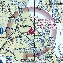
| Sectional chart |
|---|
|
CAUTION: Diagram may not be current

| Airport distance calculator |
|---|
|
|
| Sunrise and sunset |
|---|
|
Times for 09-Apr-2026
| | Local
(UTC-4) | | Zulu
(UTC) |
|---|
| Morning civil twilight | | 06:14 | | 10:14 |
| Sunrise | | 06:40 | | 10:40 |
| Sunset | | 19:32 | | 23:32 |
| Evening civil twilight | | 19:58 | | 23:58 |
|
| Current date and time |
|---|
| Zulu (UTC) | 10-Apr-2026 00:31:54 |
|---|
| Local (UTC-4) | 09-Apr-2026 20:31:54 |
|---|
|
| METAR |
|---|
| KONX | 100015Z AUTO 04005KT 10SM CLR 10/07 A3045 RMK AO2 T01010070
|
KECG
11nm SW | 092354Z 07010KT 10SM CLR 11/07 A3044 RMK AO2 SLP309 T01060067 10156 20106 50001
|
KNFE
18nm N | 092358Z AUTO 06005KT 10SM CLR 09/06 A3045 RMK AO2 SLP313 T00890061 10144 20089 58003
|
|
| TAF |
|---|
KECG
11nm SW | 091720Z 0918/1018 06012KT P6SM SCT040 FM100000 04004KT P6SM SKC FM100900 03003KT 4SM BR SCT015 FM101200 05005KT P6SM SKC
|
|
| NOTAMs |
|---|
NOTAMs are issued by the DoD/FAA and will open in a separate window not controlled by AirNav.
|
|


