FAA INFORMATION EFFECTIVE 16 APRIL 2026
Location
| FAA Identifier: | PCZ |
| Lat/Long: | 44-19-59.7000N 089-01-11.2000W
44-19.995000N 089-01.186667W
44.3332500,-89.0197778
(estimated) |
| Elevation: | 840.2 ft. / 256.1 m (surveyed) |
| Variation: | 01W (1995) |
| From city: | 3 miles SE of WAUPACA, WI |
| Time zone: | UTC -5 (UTC -6 during Standard Time) |
| Zip code: | 54981 |
Airport Operations
| Airport use: | Open to the public |
| Activation date: | 08/1945 |
| Control tower: | no |
| ARTCC: | MINNEAPOLIS CENTER |
| FSS: | GREEN BAY FLIGHT SERVICE STATION |
| NOTAMs facility: | PCZ (NOTAM-D service available) |
| Attendance: | MON-FRI 0800-1700, SEP - MAY 0800-1700
OPEN MEMORIAL DAY TO LABOR DAY. |
| Wind indicator: | lighted |
| Segmented circle: | yes |
| Lights: | ACTVT REIL RWY 10 & 28; MIRL RWY 13/31 - CTAF. MIRL RWY 10/28 PRESET TO LOW SS-SR; TO INCR INTST & ACTVT - CTAF. |
| Beacon: | white-green (lighted land airport)
Operates sunset to sunrise. |
Airport Communications
| CTAF/UNICOM: | 122.8 |
| WX AWOS-3: | 118.625 (920-867-2407) |
| MINNEAPOLIS ARTCC APPROACH: | 126.3 |
| MINNEAPOLIS ARTCC DEPARTURE: | 126.3 |
- APCH/DEP SVC PRVDD BY MINNEAPOLIS ARTCC ON FREQS 124.4/317.7 (MOSINEE RCAG).
Nearby radio navigation aids
| VOR radial/distance | | VOR name | | Freq | | Var |
|---|
| OSHr314/28.7 | | OSHKOSH VOR/DME | | 116.75 | | 02E |
| GRBr248/37.8 | | GREEN BAY VORTAC | | 115.50 | | 01E |
Airport Services
| Fuel available: | 100LL JET-A+
100LL:24 HR FUEL AVBL WITH CREDIT CARD. |
| Parking: | hangars and tiedowns |
| Airframe service: | MAJOR |
| Powerplant service: | MAJOR |
| Bottled oxygen: | NONE |
| Bulk oxygen: | NONE |
Runway Information
Runway 10/28
| Dimensions: | 5200 x 100 ft. / 1585 x 30 m |
| Surface: | asphalt, in fair condition |
| Runway edge lights: | medium intensity |
| RUNWAY 10 | | RUNWAY 28 |
| Latitude: | 44-20.001925N | | 44-19.950500N |
| Longitude: | 089-01.973585W | | 089-00.783427W |
| Elevation: | 840.0 ft. | | 805.2 ft. |
| Traffic pattern: | left | | left |
| Runway heading: | 094 magnetic, 093 true | | 274 magnetic, 273 true |
| Markings: | nonprecision, in fair condition | | nonprecision, in fair condition |
| Visual slope indicator: | 2-light PAPI on left (3.00 degrees glide path)
PAPI ON CONTINUOUSLY. | | 2-light PAPI on left (3.00 degrees glide path)
PAPI ON CONTINUOUSLY. |
| Runway end identifier lights: | yes | | yes |
| Touchdown point: | yes, no lights | | yes, no lights |
| Obstructions: | none | | 59 ft. trees, 1500 ft. from runway, 350 ft. right of centerline, 22:1 slope to clear |
Runway 13/31
| Dimensions: | 3899 x 75 ft. / 1188 x 23 m |
| Surface: | asphalt, in poor condition
NMRS CRACKS AND VEGETATION IN PAVEMENT. |
| Weight bearing capacity: | |
| Runway edge lights: | medium intensity |
| Runway edge markings: | MRKGS FADED. |
| RUNWAY 13 | | RUNWAY 31 |
| Latitude: | 44-20.199772N | | 44-19.842705N |
| Longitude: | 089-01.301343W | | 089-00.558585W |
| Elevation: | 826.6 ft. | | 802.8 ft. |
| Traffic pattern: | left | | left |
| Runway heading: | 124 magnetic, 123 true | | 304 magnetic, 303 true |
| Markings: | nonprecision, in poor condition | | nonprecision, in poor condition |
| Visual slope indicator: | 4-light PAPI on left (4.00 degrees glide path)
PAPI ON CONTINUOUSLY. | | 2-light PAPI on left (3.00 degrees glide path)
PAPI ON CONTINUOUSLY. |
| Runway end identifier lights: | no | | no |
| Touchdown point: | yes, no lights | | yes, no lights |
| Obstructions: | 75 ft. trees, 1330 ft. from runway, 210 ft. right of centerline, 15:1 slope to clear | | none |
Airport Ownership and Management from official FAA records
| Ownership: | Publicly-owned |
| Owner: | CITY OF WAUPACA
CITY HALL
WAUPACA, WI 54981
Phone 715-258-4411 |
| Manager: | MATHEW KLATT
2601 RUNWAY DRIVE
WAUPACA, WI 54981
Phone 715-258-4427
AFT HRS CALL 920-225-9881. |
Additional Remarks
| - | TWY LGTS AT ENTRANCE ONLY. |
| - | FOR CD CTC MINNEAPOLIS ARTCC AT 651-463-5588. |
Instrument Procedures
NOTE: All procedures below are presented as PDF files. If you need a reader for these files, you should download the free Adobe Reader.NOT FOR NAVIGATION. Please procure official charts for flight.
FAA instrument procedures published for use from 16 April 2026 at 0901Z to 14 May 2026 at 0900Z.
IAPs - Instrument Approach Procedures |
|---|
| RNAV (GPS) RWY 10 | |
download (220KB) |
| RNAV (GPS) RWY 28 | |
download (206KB) |
| NOTE: Special Alternate Minimums apply | |
download (154KB) |
| NOTE: Special Take-Off Minimums/Departure Procedures apply | |
download (201KB) |
Other nearby airports with instrument procedures:
KCLI - Clintonville Municipal Airport (21 nm NE)
Y50 - Wautoma Municipal Airport (21 nm SW)
KATW - Appleton International Airport (22 nm E)
KSTE - Stevens Point Municipal Airport (25 nm NW)
KOSH - Wittman Regional Airport (29 nm SE)
|
|

Road maps at:
MapQuest
Bing
Google
| Aerial photo |
|---|
WARNING: Photo may not be current or correct
 Photo by Randal Geiger
Photo taken 03-Aug-2019
looking north.
Photo by Randal Geiger
Photo taken 03-Aug-2019
looking north.
Do you have a better or more recent aerial photo of Waupaca Municipal Airport that you would like to share? If so, please send us your photo.
|
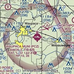
| Sectional chart |
|---|
|
CAUTION: Diagram may not be current

| Airport distance calculator |
|---|
|
|
| Sunrise and sunset |
|---|
|
Times for 19-Apr-2026
| | Local
(UTC-5) | | Zulu
(UTC) |
|---|
| Morning civil twilight | | 05:36 | | 10:36 |
| Sunrise | | 06:07 | | 11:07 |
| Sunset | | 19:44 | | 00:44 |
| Evening civil twilight | | 20:15 | | 01:15 |
|
| Current date and time |
|---|
| Zulu (UTC) | 19-Apr-2026 13:55:39 |
|---|
| Local (UTC-5) | 19-Apr-2026 08:55:39 |
|---|
|
| METAR |
|---|
| KPCZ | 191335Z AUTO 26007G16KT 10SM SCT015 BKN029 OVC049 03/M04 A3011 RMK AO2 T00251043
|
|
| TAF |
|---|
KATW
22nm E | 191222Z 1912/2012 28005KT P6SM SCT035 OVC060 TEMPO 1913/1915 5SM -SHSN BKN035 FM191500 32010G17KT P6SM BKN045 FM192100 32011G17KT P6SM BKN060 FM192200 34009G15KT P6SM SCT080 FM200100 35003KT P6SM SKC
|
|
| NOTAMs |
|---|
NOTAMs are issued by the DoD/FAA and will open in a separate window not controlled by AirNav.
|
|


