FAA INFORMATION EFFECTIVE 17 APRIL 2025
Location
| FAA Identifier: | SPA |
| Lat/Long: | 34-54-59.0590N 081-57-20.7750W
34-54.984317N 081-57.346250W
34.9164053,-81.9557708
(estimated) |
| Elevation: | 802 ft. / 244.4 m (surveyed) |
| Variation: | 05W (1995) |
| From city: | 3 miles SW of SPARTANBURG, SC |
| Time zone: | UTC -4 (UTC -5 during Standard Time) |
| Zip code: | 29376 |
Airport Operations
| Airport use: | Open to the public |
| Activation date: | 11/1937 |
| Control tower: | no |
| ARTCC: | ATLANTA CENTER |
| FSS: | ANDERSON FLIGHT SERVICE STATION |
| NOTAMs facility: | SPA (NOTAM-D service available) |
| Attendance: | 0700-1900 |
| Pattern altitude: | 1602 ft. MSL
TPA: 800 FT AGL FOR PISTON ACFT, 1300 FT AGL FOR TURBO PROP ACFT AND SML JETS. |
| Wind indicator: | lighted |
| Segmented circle: | yes |
| Lights: | ACTVT MALSR RWY 05; REIL RWY 23; PAPI RWY 05 & 23; HIRL RWY 05/23 - CTAF. |
| Beacon: | white-green (lighted land airport)
ACTVT ROTATING BCN - CTAF. Operates sunset to sunrise. |
Airport Communications
| CTAF/UNICOM: | 123.0 |
| WX AWOS-3: | 133.925 (864-587-2529) |
| GREER APPROACH: | 119.4 |
| GREER DEPARTURE: | 119.4 |
| CLEARANCE DELIVERY: | 120.55 |
| BIMMR DP: | 119.4R |
| BWALL DP: | 119.4 |
| WX ASOS at GSP (13 nm W): | PHONE 864-334-6232 |
| WX ASOS at GMU (20 nm W): | 127.075 (864-239-0014) |
- APCH/DEP SVC PRVDD BY ATLANTA ARTCC ON FREQS 135.35/263.125 (OWING RCAG) WHEN GREER APCH CTL CLSD.
Nearby radio navigation aids
| VOR radial/distance | | VOR name | | Freq | | Var |
|---|
| SPAr193/7.2 | | SPARTANBURG VORTAC | | 115.70 | | 02W |
| SUGr154/33.2 | | SUGARLOAF MOUNTAIN VORTAC | | 112.20 | | 02W |
Airport Services
| Fuel available: | 100LL JET-A
100LL:FOR FUEL AFT HRS CALL 864-574-8552. |
| Parking: | hangars and tiedowns |
| Airframe service: | MAJOR |
| Powerplant service: | MAJOR |
| Bottled oxygen: | NONE |
| Bulk oxygen: | NONE |
Runway Information
Runway 5/23
| Dimensions: | 5852 x 100 ft. / 1784 x 30 m |
| Surface: | asphalt, in excellent condition |
| Weight bearing capacity: | | PCN 37 /F/C/X/T | | Single wheel: | 95.0 | | Double wheel: | 131.0 |
|
| Runway edge lights: | high intensity |
| RUNWAY 5 | | RUNWAY 23 |
| Latitude: | 34-54.623530N | | 34-55.345083N |
| Longitude: | 081-57.734858W | | 081-56.957570W |
| Elevation: | 794.5 ft. | | 786.5 ft. |
| Traffic pattern: | left | | left |
| Runway heading: | 047 magnetic, 042 true | | 227 magnetic, 222 true |
| Declared distances: | TORA:5852 TODA:5852 ASDA:5852 LDA:5852 | | TORA:5852 TODA:5852 ASDA:5452 LDA:5452 |
| Markings: | precision, in good condition | | precision, in good condition |
| Visual slope indicator: | 4-light PAPI on right (3.00 degrees glide path) | | 4-light PAPI on left (3.00 degrees glide path) |
| Approach lights: | MALSR: 1,400 foot medium intensity approach lighting system with runway alignment indicator lights | | |
| Runway end identifier lights: | no | | yes |
| Touchdown point: | yes, no lights | | yes, no lights |
| Instrument approach: | ILS/DME | | |
| Obstructions: | 88 ft. tree, 3504 ft. from runway, 117 ft. right of centerline, 37:1 slope to clear | | none |
Airport Ownership and Management from official FAA records
| Ownership: | Publicly-owned |
| Owner: | CITY OF SPARTANBURG
PO DRAWER 1749
SPARTANBURG, SC 29304
Phone 864-596-2000 |
| Manager: | TERRY CONNORTON
500 AMMONS RD
SPARTANBURG, SC 29306
Phone (864) 580-5004 |
Additional Remarks
| - | GLIDER OPS. |
| - | FOR CD IF UNA TO CTC ON FSS FREQ, CTC GREER APCH AT 864-877-8275, WHEN APCH CLSD CTC ATLANTA ARTCC AT 770-210-7692. |
Instrument Procedures
NOTE: All procedures below are presented as PDF files. If you need a reader for these files, you should download the free Adobe Reader.NOT FOR NAVIGATION. Please procure official charts for flight.
FAA instrument procedures published for use from 17 April 2025 at 0901Z to 15 May 2025 at 0900z.
STARs - Standard Terminal Arrivals |
|---|
| JUNNR FOUR (RNAV) | |
download (154KB) |
| MCHLN TWO (RNAV) | |
download (121KB) |
| RCTOR THREE (RNAV) **NEW** | |
download (122KB) |
| WORXS TWO (RNAV) | |
download (155KB) |
IAPs - Instrument Approach Procedures |
|---|
| ILS OR LOC RWY 05 | |
download (240KB) |
| RNAV (GPS) RWY 05 | |
download (236KB) |
| RNAV (GPS) RWY 23 | |
download (223KB) |
| NOTE: Special Alternate Minimums apply | |
download (142KB) |
Departure Procedures |
|---|
| BIMMR THREE (RNAV) | |
download (161KB) |
| BWALL TWO (RNAV) | |
download (161KB) |
| NOTE: Special Take-Off Minimums/Departure Procedures apply | |
download (355KB) |
Other nearby airports with instrument procedures:
KGSP - Greenville Spartanburg International Airport (13 nm W)
KGMU - Greenville Downtown Airport (20 nm W)
35A - Union County Airport, Troy Shelton Field (21 nm SE)
KGYH - Donaldson Field Airport (23 nm SW)
KLUX - Laurens County Airport (25 nm S)
|
|

Road maps at:
MapQuest
Bing
Google
| Aerial photo |
|---|
WARNING: Photo may not be current or correct
 Photo courtesy of AirNav, LLC
Photo taken 28-Sep-2012
looking north.
Photo courtesy of AirNav, LLC
Photo taken 28-Sep-2012
looking north.
Do you have a better or more recent aerial photo of Spartanburg Downtown Memorial Airport/Simpson Field that you would like to share? If so, please send us your photo.
|
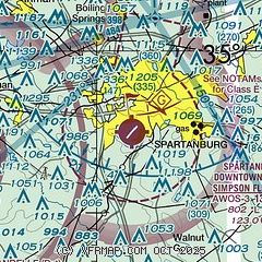
| Sectional chart |
|---|
|
CAUTION: Diagram may not be current

| Airport distance calculator |
|---|
|
|
| Sunrise and sunset |
|---|
|
Times for 25-Apr-2025
| | Local
(UTC-4) | | Zulu
(UTC) |
|---|
| Morning civil twilight | | 06:18 | | 10:18 |
| Sunrise | | 06:45 | | 10:45 |
| Sunset | | 20:07 | | 00:07 |
| Evening civil twilight | | 20:34 | | 00:34 |
|
| Current date and time |
|---|
| Zulu (UTC) | 25-Apr-2025 19:55:50 |
|---|
| Local (UTC-4) | 25-Apr-2025 15:55:50 |
|---|
|
| METAR |
|---|
KSPA
7nm N | 251935Z AUTO 23003KT 10SM BKN030 BKN039 OVC047 23/16 A3015 RMK AO2
|
KGSP
13nm W | 251853Z 26006KT 10SM OVC033 22/16 A3019 RMK AO2 SLP214 T02220161
|
KGMU
20nm W | 251925Z 31004KT 10SM OVC030 22/17 A3017 RMK AO2 T02170172
|
|
| TAF |
|---|
KGSP
13nm W | 251720Z 2518/2618 21007KT P6SM SCT015 BKN035 TEMPO 2518/2520 BKN015 FM260400 22006KT 5SM -SHRA SCT025 OVC050 TEMPO 2604/2608 2SM +RA FM260800 23006KT P6SM OVC015 FM261600 24006KT P6SM SCT025 BKN050
|
KGMU
20nm W | 251720Z 2518/2618 21007KT P6SM SCT015 BKN035 TEMPO 2518/2520 BKN015 FM260400 22006KT 5SM -SHRA SCT025 OVC050 TEMPO 2604/2608 2SM +RA FM260800 23006KT P6SM OVC015 FM261600 24006KT P6SM SCT025 BKN050
|
|
| NOTAMs |
|---|
NOTAMs are issued by the DoD/FAA and will open in a separate window not controlled by AirNav.
|
|


