FAA INFORMATION EFFECTIVE 02 OCTOBER 2025
Location
| FAA Identifier: | VDF |
| Lat/Long: | 28-00-50.3540N 082-20-42.9330W
28-00.839233N 082-20.715550W
28.0139872,-82.3452592
(estimated) |
| Elevation: | 21.1 ft. / 6.4 m (surveyed) |
| Variation: | 04W (2000) |
| From city: | 6 miles E of TAMPA, FL |
| Time zone: | UTC -4 (UTC -5 during Standard Time) |
| Zip code: | 33610 |
Airport Operations
| Airport use: | Open to the public |
| Activation date: | 05/1957 |
| Control tower: | no |
| ARTCC: | MIAMI CENTER |
| FSS: | SAINT PETERSBURG FLIGHT SERVICE STATION |
| NOTAMs facility: | VDF (NOTAM-D service available) |
| Attendance: | MON-FRI 0700-2200, ALL SAT-SUN 0700-1900 |
| Wind indicator: | lighted |
| Segmented circle: | yes |
| Lights: | ACTVT MALSR RWY 23; REIL RWY 05, 18, 36; PAPI RWY 05, 23, 18, 36; MIRL RWY 05/23, 18/36 - CTAF. |
| Beacon: | white-green (lighted land airport)
Operates sunset to sunrise. |
Airport Communications
| CTAF/UNICOM: | 122.7 |
| WX AWOS-3: | 121.125 (813-630-0924) |
| TAMPA APPROACH: | 119.9 |
| TAMPA DEPARTURE: | 119.9 |
| DADES STAR: | 135.5 |
| MAATY STAR: | 118.8 |
| WX AWOS-3 at TPF (8 nm SW): | 118.925 (813-251-6824) |
| WX AWOS-3 at PCM (10 nm E): | 120.025 (813-764-8259) |
| WX ASOS at TPA (10 nm W): | 126.45 (813-296-2752) |
| WX AWOS-3PT at ZPH (16 nm NE): | 118.975 (813-780-0031) |
| WX AWOS-3PT at LAL (17 nm E): | PHONE 863-834-2030 |
| WX ASOS at PIE (19 nm W): | 134.5 (727-502-6385) |
Nearby radio navigation aids
| VOR radial/distance | | VOR name | | Freq | | Var |
|---|
| LALr274/17.6 | | LAKELAND VORTAC | | 116.00 | | 01E |
| PIEr075/19.1 | | ST PETERSBURG VORTAC | | 116.40 | | 05W |
| SRQr023/38.2 | | SARASOTA VOR/DME | | 117.00 | | 05W |
Airport Services
| Fuel available: | 100LL JET-A |
| Parking: | hangars and tiedowns |
| Airframe service: | MAJOR |
| Powerplant service: | MAJOR |
| Bottled oxygen: | NONE |
| Bulk oxygen: | NONE |
Runway Information
Runway 5/23
| Dimensions: | 5000 x 100 ft. / 1524 x 30 m |
| Surface: | asphalt, in excellent condition |
| Weight bearing capacity: | | PCN 12 /F/A/X/T | | Single wheel: | 34.5 | | Double wheel: | 63.0 |
|
| Runway edge lights: | medium intensity |
| RUNWAY 5 | | RUNWAY 23 |
| Latitude: | 28-00.727325N | | 28-01.336483N |
| Longitude: | 082-20.862127W | | 082-20.235100W |
| Elevation: | 19.2 ft. | | 21.0 ft. |
| Traffic pattern: | left | | left |
| Runway heading: | 046 magnetic, 042 true | | 226 magnetic, 222 true |
| Displaced threshold: | no | | 800 ft. |
| Declared distances: | TORA:4574 TODA:4574 ASDA:4956 LDA:4956 | | TORA:5000 TODA:5000 ASDA:5000 LDA:4200 |
| Markings: | nonprecision, in good condition | | precision, in good condition |
| Visual slope indicator: | 2-light PAPI on left (3.02 degrees glide path) | | 2-light PAPI on left (3.10 degrees glide path) |
| Approach lights: | | | MALSR: 1,400 foot medium intensity approach lighting system with runway alignment indicator lights |
| Runway end identifier lights: | yes | | no |
| Touchdown point: | yes, no lights | | yes, no lights |
| Instrument approach: | | | ILS/DME |
| Obstructions: | 43 ft. trees, 1955 ft. from runway, 245 ft. left of centerline, 40:1 slope to clear | | 17 ft. road, 310 ft. from runway, 500 ft. left of centerline, 6:1 slope to clear
RWY 23 APCH SLOPE 50:1 TO DTHR. |
Runway 18/36
| Dimensions: | 3219 x 75 ft. / 981 x 23 m |
| Surface: | asphalt, in fair condition |
| Weight bearing capacity: | | PCN 21 /F/B/X/T | | Single wheel: | 59.0 | | Double wheel: | 84.0 |
|
| Runway edge lights: | medium intensity |
| RUNWAY 18 | | RUNWAY 36 |
| Latitude: | 28-00.805620N | | 28-00.274385N |
| Longitude: | 082-20.973797W | | 082-20.975733W |
| Elevation: | 18.4 ft. | | 18.5 ft. |
| Traffic pattern: | left | | left |
| Runway heading: | 184 magnetic, 180 true | | 004 magnetic, 000 true |
| Declared distances: | TORA:3219 TODA:3219 ASDA:3219 LDA:3219 | | TORA:3219 TODA:3219 ASDA:3219 LDA:3219 |
| Markings: | nonprecision, in fair condition | | nonprecision, in fair condition |
| Visual slope indicator: | 4-light PAPI on right (3.80 degrees glide path) | | 2-light PAPI on left (3.40 degrees glide path) |
| Runway end identifier lights: | yes | | yes |
| Touchdown point: | yes, no lights | | yes, no lights |
| Obstructions: | 20 ft. brush, 480 ft. from runway, 100 ft. left of centerline, 14:1 slope to clear
RWY 18 APCH SLOPE 30:1 TO AER. | | 123 ft. pole, lighted, 2895 ft. from runway, 20 ft. left of centerline, 22:1 slope to clear |
Airport Ownership and Management from official FAA records
| Ownership: | Publicly-owned |
| Owner: | HILLSBOROUGH COUNTY AVIATION AUTH
PO BOX 22287
TAMPA, FL 33622
Phone 813-870-8711 |
| Manager: | BRETT W FAY, C.M.
PO BOX 22287
TAMPA, FL 33622
Phone (813) 870-8735 |
Additional Remarks
| - | AFTER HRS FUEL AND SVCS AVBL. JET SINGLE POINT FUELING AND LAV SVS AVBL. CTC FBO ON CALL ATTENDANT AT 813-695-6097. |
| - | CTC GENERAL AVIATION DEPT AT 813-870-8770. |
| - | NOISE ABATEMENT PROCEDURES IN EFFECT FOR RY 18. NO TURNS UNTIL OVER INTERSTATE. NO TURNS BLO 400 FT AGL. |
| - | WHEN DEPG RWY 05 BE ALERT FOR MALSR LGT FIXTURE LCTD 55 FT BYD RWY END & 9 FT ABV RWY END ELEV. |
| - | FOR CD CTC TAMPA APCH ON 119.9. |
| - | TREES 510 FT NW OF RWY 5/23 FULL LEN LCTD INSIDE TRSN SFC. |
| - | BE ADZD OF SEAPLANE FLT ACTIVITY 3NM SE OF ARPT. |
Instrument Procedures
NOTE: All procedures below are presented as PDF files. If you need a reader for these files, you should download the free Adobe Reader.NOT FOR NAVIGATION. Please procure official charts for flight.
FAA instrument procedures published for use from 02 October 2025 at 0901Z to 30 October 2025 at 0900z.
STARs - Standard Terminal Arrivals |
|---|
| DADES TWO (RNAV) | |
2 pages:
[1] [2] (425KB) |
| MAATY FIVE (RNAV) | |
2 pages:
[1] [2] (292KB) |
| MAATY FIVE (RNAV), CONT.2 | |
download (128KB) |
| RAYZZ THREE (RNAV) | |
2 pages:
[1] [2] (436KB) |
IAPs - Instrument Approach Procedures |
|---|
| ILS OR LOC RWY 23 | |
download (236KB) |
| RNAV (GPS) RWY 05 | |
download (248KB) |
| RNAV (GPS) RWY 18 | |
download (207KB) |
| RNAV (GPS) RWY 23 | |
download (228KB) |
| NOTE: Special Alternate Minimums apply | |
download (124KB) |
| NOTE: Special Take-Off Minimums/Departure Procedures apply | |
download (408KB) |
Other nearby airports with instrument procedures:
KTPF - Peter O Knight Airport (8 nm SW)
KPCM - Plant City Airport (10 nm E)
KTPA - Tampa International Airport (10 nm W)
KMCF - MacDill Air Force Base (14 nm SW)
KZPH - Zephyrhills Municipal Airport (16 nm NE)
KLAL - Lakeland Linder International Airport (17 nm E)
KPIE - St Pete-Clearwater International Airport (19 nm W)
|
|

Road maps at:
MapQuest
Bing
Google
| Aerial photo |
|---|
WARNING: Photo may not be current or correct
 Photo courtesy of PhotosFromTheAir.com
Photo taken 27-Feb-2012
looking east.
Photo courtesy of PhotosFromTheAir.com
Photo taken 27-Feb-2012
looking east.
Do you have a better or more recent aerial photo of Tampa Executive Airport that you would like to share? If so, please send us your photo.
|
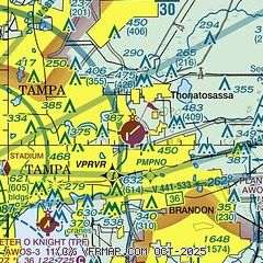
| Sectional chart |
|---|
|
| Airport distance calculator |
|---|
|
|
| Sunrise and sunset |
|---|
|
Times for 09-Oct-2025
| | Local
(UTC-4) | | Zulu
(UTC) |
|---|
| Morning civil twilight | | 07:04 | | 11:04 |
| Sunrise | | 07:27 | | 11:27 |
| Sunset | | 19:06 | | 23:06 |
| Evening civil twilight | | 19:29 | | 23:29 |
|
| Current date and time |
|---|
| Zulu (UTC) | 09-Oct-2025 06:57:31 |
|---|
| Local (UTC-4) | 09-Oct-2025 02:57:31 |
|---|
|
| METAR |
|---|
KPCM
10nm E | 090635Z AUTO 03004KT 10SM CLR 25/23 A2999 RMK AO2
|
KTPA
10nm W | 090653Z 03005KT 10SM CLR 24/23 A2997 RMK AO2 SLP149 T02390228
|
KMCF
13nm SW | 090655Z AUTO 05008KT 10SM CLR 24/22 A2996 RMK AO2 SLP148 T02380220
|
KZPH
16nm NE | 090635Z AUTO 36005KT 10SM CLR 22/21 A2999 RMK A02 T02160212
|
KLAL
18nm E | 090550Z 03005KT 10SM SKC 24/23 A2998
|
KPIE
19nm W | 090653Z AUTO 05006KT 10SM CLR 24/23 A2997 RMK AO2 SLP148 T02440228
|
|
| TAF |
|---|
KTPA
10nm W | 090526Z 0906/1012 04007KT P6SM SCT015 SCT250 FM091600 05010G18KT P6SM SCT035 SCT250 FM100100 03008KT P6SM FEW020 BKN250
|
KMCF
13nm SW | 090100Z 0901/1007 06009KT 9999 FEW050 QNH2994INS BECMG 0914/0915 05012G20KT 9999 SCT030 SCT150 QNH2989INS BECMG 1000/1001 06012KT 9999 SCT030 BKN120 QNH2991INS TX32/0918Z TN23/0910Z
|
KLAL
18nm E | 090526Z 0906/1006 04007KT P6SM SCT010 SCT250 FM091600 06012G20KT P6SM BKN035 BKN100 FM100100 03008KT P6SM SCT025 BKN080
|
KPIE
19nm W | 090526Z 0906/1006 04008KT P6SM SCT015 SCT250 FM091600 05012G20KT P6SM SCT035 SCT250 FM100100 04010KT P6SM FEW020 BKN250
|
|
| NOTAMs |
|---|
NOTAMs are issued by the DoD/FAA and will open in a separate window not controlled by AirNav.
|
|


