FAA INFORMATION EFFECTIVE 09 JULY 2026
Location
| FAA Identifier: | TPA |
| Lat/Long: | 27-58-31.6900N 082-31-59.6910W
27-58.528167N 082-31.994850W
27.9754694,-82.5332475
(estimated) |
| Elevation: | 26.5 ft. / 8.1 m (surveyed) |
| Variation: | 05W (2010) |
| From city: | 6 miles W of TAMPA, FL |
| Time zone: | UTC -4 (UTC -5 during Standard Time) |
| Zip code: | 33614 |
Airport Operations
| Airport use: | Open to the public |
| Activation date: | 04/1940 |
| Control tower: | yes |
| ARTCC: | MIAMI CENTER |
| FSS: | SAINT PETERSBURG FLIGHT SERVICE STATION |
| NOTAMs facility: | TPA (NOTAM-D service available) |
| Attendance: | CONTINUOUS |
| Wind indicator: | lighted |
| Segmented circle: | yes |
| Lights: | SS-SR |
| Beacon: | white-green (lighted land airport)
Operates sunset to sunrise. |
| Fire and rescue: | ARFF index D |
| International operations: | international airport of entry |
Airport Communications
| UNICOM: | 122.95 |
| WX ASOS: | 126.45 (813-296-2752) |
| TAMPA GROUND: | 121.7 269.4 121.35 |
| TAMPA TOWER: | 119.5 269.4 119.05 |
| TAMPA APPROACH: | 118.15 ;001-150 118.5 134.25 ;151-219 239.3 ;220-360 279.6 ;001-150 307.175 353.575 ;151-219 353.75 |
| TAMPA DEPARTURE: | 118.15 ;001-150 118.8 ;220-360 239.3 ;220-360 279.6 ;001-150 307.175 353.575 ;151-219 353.75 |
| CLEARANCE DELIVERY: | 133.6 |
| BAYPO DP: | 118.8 239.3 |
| BLFRG STAR: | 119.65 353.575 |
| CLASS B: | 119.65 ;151-219 119.9 ;001-150 125.3 ;220-360 290.3 ;001-150 316.05 ;220-360 353.575 ;151-219 |
| CROWD DP: | 135.5 279.6 |
| D-ATIS: | 126.45 ;ARR 128.475 ;DEP |
| DADES STAR: | 135.5 279.6 |
| DORMR DP: | 118.8 239.3 |
| EMERG: | 121.5 243.0 |
| ENDED DP: | 118.8 239.3 |
| GANDY DP: | 119.65 353.575 |
| IC: | 118.5 118.8 ;220-360 307.175 |
| KNOST DP: | 118.8 239.3 |
| LGTNG DP: | 118.8 239.3 |
| MAATY STAR: | 118.8 239.3 |
| RAYZZ STAR: | 118.8 239.3 |
| TAMPA DP: | 134.25 279.6 |
| WX AWOS-3 at TPF (6 nm SE): | 118.925 (813-251-6824) |
| WX ASOS at PIE (9 nm SW): | 134.5 (727-502-6385) |
| WX AWOS-3 at VDF (10 nm E): | 121.125 (813-630-0924) |
| WX AWOS-3P at CLW (12 nm W): | 119.225 (727-462-6383) |
| WX ASOS at SPG (14 nm S): | 118.875 (727-821-4334) |
| WX AWOS-3 at PCM (20 nm E): | 120.025 (813-764-8259) |
- TA31 ASR-6 REMOTED AT SARASOTA-BRADENTON ARPT.
- SAID IN USE. OPERATE TRANSPONDERS WITH ALTITUDE REPORTING MODE AND ADS-B (IF EQUIPPED) ENABLED ON ALL AIRPORT SURFACES.
Nearby radio navigation aids
| VOR radial/distance | | VOR name | | Freq | | Var |
|---|
| PIEr068/9.0 | | ST PETERSBURG VORTAC | | 116.40 | | 05W |
| LALr268/27.5 | | LAKELAND VORTAC | | 116.00 | | 01E |
| SRQr008/34.1 | | SARASOTA VOR/DME | | 117.00 | | 05W |
| NDB name | | Hdg/Dist | | Freq | | Var | | ID |
|---|
| CAPOK | | 102/9.1 | | 360 | | 05W | | PI | .--. .. |
Airport Services
| Fuel available: | 100LL JET-A |
| Parking: | hangars and tiedowns |
| Airframe service: | MAJOR |
| Powerplant service: | MAJOR |
| Bottled oxygen: | HIGH/LOW |
| Bulk oxygen: | HIGH/LOW |
Runway Information
Runway 1L/19R
| Dimensions: | 11002 x 150 ft. / 3353 x 46 m |
| Surface: | concrete/grooved, in good condition |
| Weight bearing capacity: | | Single wheel: | 120.0 | | Double wheel: | 228.0 | | Double tandem: | 443.0 | | Dual double tandem: | 968.0 |
|
| Runway edge lights: | high intensity |
| RUNWAY 1L | | RUNWAY 19R |
| Latitude: | 27-57.797660N | | 27-59.612367N |
| Longitude: | 082-32.541325W | | 082-32.479670W |
| Elevation: | 10.8 ft. | | 20.9 ft. |
| Traffic pattern: | left | | left |
| Runway heading: | 007 magnetic, 002 true | | 187 magnetic, 182 true |
| Declared distances: | TORA:11002 TODA:11002 ASDA:10800 LDA:10800 | | TORA:11002 TODA:11002 ASDA:11002 LDA:11002 |
| Markings: | precision, in good condition | | precision, in good condition |
| Visual slope indicator: | 4-light PAPI on left (3.00 degrees glide path) | | 4-light PAPI on left (3.00 degrees glide path) |
| RVR equipment: | touchdown, midfield, rollout | | touchdown, midfield, rollout |
| Approach lights: | ALSF2: standard 2,400 foot high intensity approach lighting system with centerline sequenced flashers (category II or III) | | MALSR: 1,400 foot medium intensity approach lighting system with runway alignment indicator lights |
| Runway end identifier lights: | no | | no |
| Centerline lights: | yes | | yes |
| Touchdown point: | yes, lighted | | yes, no lights |
| Instrument approach: | ILS/DME | | ILS/DME |
| Obstructions: | none | | 15 ft. road, 955 ft. from runway, 500 ft. right of centerline |
Runway 1R/19L
| Dimensions: | 8300 x 150 ft. / 2530 x 46 m |
| Surface: | asphalt/concrete/grooved, in good condition |
| Weight bearing capacity: | | Single wheel: | 120.0 | | Double wheel: | 208.0 | | Double tandem: | 392.0 | | Dual double tandem: | 896.0 |
|
| Runway edge lights: | high intensity |
| RUNWAY 1R | | RUNWAY 19L |
| Latitude: | 27-57.858620N | | 27-59.227677N |
| Longitude: | 082-31.739482W | | 082-31.692903W |
| Elevation: | 17.6 ft. | | 26.0 ft. |
| Traffic pattern: | left | | left |
| Runway heading: | 007 magnetic, 002 true | | 187 magnetic, 182 true |
| Declared distances: | TORA:8300 TODA:8300 ASDA:8300 LDA:8300 | | TORA:8300 TODA:8300 ASDA:8300 LDA:8300 |
| Markings: | precision, in good condition | | precision, in good condition |
| Visual slope indicator: | 4-light PAPI on left (3.00 degrees glide path) | | 4-light PAPI on left (3.00 degrees glide path) |
| RVR equipment: | touchdown, midfield, rollout | | touchdown, midfield, rollout |
| Approach lights: | | | ALSF2: standard 2,400 foot high intensity approach lighting system with centerline sequenced flashers (category II or III) |
| Runway end identifier lights: | yes | | no |
| Centerline lights: | yes | | yes |
| Touchdown point: | yes, no lights | | yes, lighted |
| Instrument approach: | LOC/DME | | ILS/DME |
Runway 10/28
| Dimensions: | 6999 x 150 ft. / 2133 x 46 m |
| Surface: | asphalt/concrete/grooved, in fair condition
RWY 10 FIRST 2600 FT CONC; RWY 28 FIRST 4400 FT ASPH. |
| Weight bearing capacity: | | Single wheel: | 120.0 | | Double wheel: | 250.0 | | Double tandem: | 550.0 | | Dual double tandem: | 1113.0 |
|
| Runway edge lights: | high intensity |
| Operational restrictions: | NOT NMLY AVBL TO OPNS OVER 75,000 LBS GWT. |
| RUNWAY 10 | | RUNWAY 28 |
| Latitude: | 27-58.249863N | | 27-58.214838N |
| Longitude: | 082-32.165060W | | 082-30.864635W |
| Elevation: | 14.6 ft. | | 26.5 ft. |
| Traffic pattern: | left | | left |
| Runway heading: | 097 magnetic, 092 true | | 277 magnetic, 272 true |
| Displaced threshold: | 498 ft. | | no |
| Declared distances: | TORA:6999 TODA:6999 ASDA:6999 LDA:6501 | | TORA:6999 TODA:6999 ASDA:6501 LDA:6501 |
| Markings: | nonprecision, in good condition | | nonprecision, in good condition |
| Visual slope indicator: | 4-light PAPI on left (3.00 degrees glide path)
RWY 10 PAPI UNUSBL 8 DEG LEFT AND RIGHT OF RCL. | | 4-light PAPI on left (3.00 degrees glide path) |
| Runway end identifier lights: | no | | no |
| Touchdown point: | yes, no lights | | yes, no lights |
| Obstructions: | 18 ft. rr, 755 ft. from runway, 300 ft. left of centerline, 30:1 slope to clear
RWY 10 APCH SFC IS 50:1 TO MKD DSPLCD THR. | | 41 ft. trees, 1660 ft. from runway, 190 ft. left of centerline, 35:1 slope to clear |
Airport Ownership and Management from official FAA records
| Ownership: | Publicly-owned |
| Owner: | HILLSBOROUGH CO AVN AUTHORITY
PO BOX 22287
TAMPA, FL 33622
Phone 813-870-8700 |
| Manager: | JOHN TILIACOS
PO BOX 22287
TAMPA, FL 33622
Phone 813-870-8700
813-870-8752 |
Additional Remarks
| A39-01L/19R | PCR VALUE: 700/R/A/W/T |
| A39-10/28 | PCR VALUE: 870/R/A/W/T |
| A39-01R/19L | PCR VALUE: 630/R/A/W/T |
| - | RSTRS TO ADG IV OR LGR: TWY E1. |
| - | TXL K1 AND TXL K2 CLSD TO WINGSPANS GTR THAN 171 FT, TXL K1 AND TXL K2 CLSD WHILE WIDE BODY TXL K1W IS IN USE. |
| - | TWY J BTN TWY J1 AND TWY J2; TWY N W OF TWY L; TWY E N OF TWY J; TXL Z 325 FT E OF TXL V; TXL V BTN TWY V2 AND TWY V3 ARE UNAVBL FOR GROUP V ACFT WITH A WINGSPAN GTR THAN 171 FT WO PPR FROM ARPT OPS. |
| - | 24 HR ADVN NOTICE OR IMT REPORTING UPON LDG FOR ACFT EQUIPPED WITH WEATHER MODIFICATION OR GEOENGINEERING EQUIP. 813-870-8770 EXT. 3 |
| - | US CUST AVBL 7 DAYS A WEEK, 0600-2200 HOURS. PPR 24 HOURS FOR AFT HOURS; CTC CBP SUPVR AT 813-676-4590; CTC AIRPORT OPERATIONS AT 813-870-8770. |
| - | N RON RSTD TO TUG IN/TUG OUT OPS FOR ADG III OR LGR |
| - | RWY 19L IS NOISE SENSITIVE TO TBJT DEPARTURES. RWY 01R IS NOISE SENSITIVE TO TBJT ARRIVALS. PUBLD NOISE ABATEMENT PROCS IN EFCT. |
| - | ONLY ACFT WITH PRIOR PMSN MAY USE TRML APN; ALL OTRS USE GA APN. |
| - | BIRD ACT ON AND INVOF ARPT. |
| - | TXL F AND TXL R ARE NON-MOVEMENT AREAS. BOTH LCTNS ARE UNAVBL FOR GROUP IV ACFT WITH A WINGSPAN GTR THAN 117 FT WO PPR FROM ARPT OPS. TXL T PPR FROM ARPT OPS RQRD FOR ACFT WITH A WINGSPAN GTR THAN 90 FT. |
| - | TAXILANE G WEST OF TWY B1 CLSD TO WINGSPAN GTR THAN 118 FT - PPR APT OPS. |
Instrument Procedures
NOTE: All procedures below are presented as PDF files. If you need a reader for these files, you should download the free Adobe Reader.NOT FOR NAVIGATION. Please procure official charts for flight.
FAA instrument procedures published for use from 09 July 2026 at 0901Z to 06 August 2026 at 0900Z.
STARs - Standard Terminal Arrivals |
|---|
| BLFRG THREE (RNAV) **NEW** | |
2 pages:
[1] [2] (300KB) |
| DADES TWO (RNAV) **NEW** | |
2 pages:
[1] [2] (427KB) |
| MAATY SIX (RNAV) **NEW** | |
2 pages:
[1] [2] (314KB) |
| MAATY SIX (RNAV), CONT.2 **NEW** | |
download (131KB) |
| RAYZZ THREE (RNAV) **NEW** | |
2 pages:
[1] [2] (441KB) |
IAPs - Instrument Approach Procedures |
|---|
| ILS OR LOC RWY 01L | |
download (307KB) |
| ILS OR LOC RWY 19L | |
download (279KB) |
| ILS OR LOC RWY 19R | |
download (334KB) |
| ILS RWY 01L (SA CAT I) | |
download (277KB) |
| ILS RWY 19L (SA CAT I) | |
download (255KB) |
| ILS RWY 19L (CAT II) | |
download (259KB) |
| ILS RWY 01L (CAT II - III) | |
download (284KB) |
| RNAV (RNP) Z RWY 01L | |
download (273KB) |
| RNAV (RNP) Z RWY 01R | |
download (258KB) |
| RNAV (GPS) RWY 10 | |
download (232KB) |
| RNAV (GPS) RWY 19L | |
download (276KB) |
| RNAV (GPS) RWY 19R | |
download (276KB) |
| RNAV (GPS) RWY 28 | |
download (236KB) |
| RNAV (GPS) Y RWY 01L | |
download (270KB) |
| RNAV (GPS) Y RWY 01R | |
download (259KB) |
| LOC RWY 01R | |
download (246KB) |
| NOTE: Special Alternate Minimums apply | |
download (149KB) |
Departure Procedures |
|---|
| BAYPO TWO (RNAV) | |
2 pages:
[1] [2] (301KB) |
| CROWD EIGHT (RNAV) | |
download (261KB) |
| DORMR THREE (RNAV) | |
download (242KB) |
| ENDED TWO (RNAV) | |
2 pages:
[1] [2] (251KB) |
| GANDY EIGHT (RNAV) | |
download (273KB) |
| KNOST TWO (RNAV) | |
download (207KB) |
| LGTNG FIVE | |
download (199KB) |
| TAMPA NINE | |
download (198KB) |
| NOTE: Special Take-Off Minimums/Departure Procedures apply | |
download (409KB) |
Other nearby airports with instrument procedures:
KTPF - Peter O Knight Airport (6 nm SE)
KMCF - MacDill Air Force Base (8 nm S)
KPIE - St Pete-Clearwater International Airport (9 nm SW)
KVDF - Tampa Executive Airport (10 nm E)
KCLW - Clearwater Executive Airport (12 nm W)
KSPG - Albert Whitted Airport (14 nm S)
KPCM - Plant City Airport (20 nm E)
|
|

Road maps at:
MapQuest
Bing
Google
| Aerial photo |
|---|
WARNING: Photo may not be current or correct
 Photo courtesy of PhotosFromTheAir.com
Photo taken 27-Feb-2012
Photo courtesy of PhotosFromTheAir.com
Photo taken 27-Feb-2012
Do you have a better or more recent aerial photo of Tampa International Airport that you would like to share? If so, please send us your photo.
|
| Sectional chart |
|---|
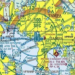
|
CAUTION: Diagram may not be current
 Download PDF
of official airport diagram from the FAA
| Airport distance calculator |
|---|
|
|
| Sunrise and sunset |
|---|
|
Times for 19-Jul-2026
| | Local
(UTC-4) | | Zulu
(UTC) |
|---|
| Morning civil twilight | | 06:21 | | 10:21 |
| Sunrise | | 06:47 | | 10:47 |
| Sunset | | 20:26 | | 00:26 |
| Evening civil twilight | | 20:52 | | 00:52 |
|
| Current date and time |
|---|
| Zulu (UTC) | 19-Jul-2026 08:34:05 |
|---|
| Local (UTC-4) | 19-Jul-2026 04:34:05 |
|---|
|
| METAR |
|---|
| KTPA | 190753Z AUTO 10005KT 10SM CLR 27/23 A2996 RMK AO2 RAB13E33 SLP145 P0000 T02670233 $
|
KMCF
8nm S | 190755Z 09010KT 10SM CLR 27/24 A2994 RMK AO2A RAB0656E06 SLP141 P0000 T02660238
|
KPIE
9nm SW | 182353Z 19005KT 10SM FEW050 FEW095 SCT110 27/24 A2998
|
KVDF
10nm E | 190815Z AUTO 09004KT 8SM -RA SCT040 SCT100 26/25 A2997 RMK AO2 LTG DSNT S AND W RAB0759 P0000 T02560245 $
|
KCLW
12nm W | 190815Z AUTO 12005KT BKN018 OVC028 26/23 A2996 RMK AO2
|
KSPG
14nm SW | 190753Z AUTO 12015KT 10SM SCT075 BKN100 27/25 A2994 RMK AO2 LTG DSNT S-W RAB03E15 SLP139 P0000 T02720250
|
KPCM
20nm E | 190815Z AUTO 11003KT 10SM FEW160 SCT230 25/24 A2998 RMK AO2 LTG DSNT S AND W T02500245 $
|
|
| TAF |
|---|
| KTPA | 190523Z 1906/2012 15004KT P6SM VCSH FEW025 BKN150 PROB30 1907/1913 4SM SHRA BKN025 FM191300 16010G17KT P6SM VCTS SCT025CB BKN150 TEMPO 1913/1917 VRB15G25KT 2SM +TSRA BKN025CB FM191800 18011G18KT P6SM VCTS SCT035CB BKN100 FM192300 17007KT P6SM SCT035 BKN150
|
KMCF
8nm S | 190709Z 1907/2007 10009KT 9999 SCT040 BKN140 QNH2995INS TEMPO 1907/1909 8000 -RA BECMG 1910/1911 13010G15KT 9999 BKN030 BKN150 QNH2997INS BECMG 1915/1916 15010G20KT 6000 -RA VCTS BKN020CB BKN140 QNH2989INS TEMPO 1916/1922 VRB20G30KT 4800 TSRA BKN015CB BECMG 2001/2002 16009KT 9999 NSW BKN020 QNH2987INS TX30/1918Z TN25/1909Z
|
KPIE
9nm SW | 190523Z 1906/2006 15006KT P6SM VCSH FEW025 BKN150 PROB30 1907/1913 4SM SHRA BKN025 FM191300 16011G18KT P6SM VCTS SCT025CB BKN150 TEMPO 1913/1917 VRB15G25KT 2SM +TSRA BKN025CB FM191800 18012G20KT P6SM VCTS SCT035CB BKN100 FM192300 17010KT P6SM SCT035 BKN150
|
|
| NOTAMs |
|---|
NOTAMs are issued by the DoD/FAA and will open in a separate window not controlled by AirNav.
|
|


