FAA INFORMATION EFFECTIVE 20 FEBRUARY 2025
Location
| FAA Identifier: | LBE |
| Lat/Long: | 40-16-23.1618N 079-24-37.1720W
40-16.386030N 079-24.619533W
40.2731005,-79.4103256
(estimated) |
| Elevation: | 1198.7 ft. / 365.4 m (surveyed) |
| Variation: | 10W (2020) |
| From city: | 2 miles SW of LATROBE, PA |
| Time zone: | UTC -5 (UTC -4 during Daylight Saving Time) |
| Zip code: | 15650 |
Airport Operations
| Airport use: | Open to the public |
| Activation date: | 04/1938 |
| Control tower: | yes |
| ARTCC: | CLEVELAND CENTER |
| FSS: | ALTOONA FLIGHT SERVICE STATION |
| NOTAMs facility: | LBE (NOTAM-D service available) |
| Attendance: | CONTINUOUS |
| Wind indicator: | lighted |
| Segmented circle: | no |
| Lights: | WHEN ATCT CLSD, ACTVT MALSR RWY 24; REIL RWY 06; HIRL RWY 06/24; TWY A, B, C & D - CTAF. |
| Beacon: | white-green (lighted land airport)
Operates sunset to sunrise. |
| Landing fee: | yes |
| Fire and rescue: | ARFF index B |
| Airline operations: | PPR 24 FOR UNSKED ACFT OPS WITH MORE THAN 9 PAX CALL AMGR 724-640-7234. |
Airport Communications
| CTAF: | 125.0 |
| ATIS: | 118.375 |
| WX AWOS-3: | PHONE 724-537-0671 |
| PALMER GROUND: | 121.8 [0615-2200] |
| PALMER TOWER: | 125.0 [0615-2200] |
| JOHNSTOWN APPROACH: | 121.2 |
| JOHNSTOWN DEPARTURE: | 121.2 |
| EMERG: | 121.5 |
| WX AWOS-3 at FWQ (20 nm W): | 118.475 (724-379-5815) |
- APCH/DEP SVC PRVDD BY CLEVELAND ARTCC (ZOB) ON FREQS 124.4/327.1 (ALTOONA RCAG) WHEN JOHNSTOWN APCH CTL CLSD.
- ATIS FREQ 118.375 USED TO TMT AWOS WX DATA WHEN ATCT CLSD.
Nearby radio navigation aids
| VOR radial/distance | | VOR name | | Freq | | Var |
|---|
| JSTr270/26.5 | | JOHNSTOWN VOR/DME | | 113.00 | | 06W |
| AGCr100/28.9 | | ALLEGHENY VOR/DME | | 110.00 | | 09W |
| NDB name | | Hdg/Dist | | Freq | | Var | | ID |
|---|
| STOYSTOWN | | 306/25.3 | | 209 | | 10W | | SYS | ... -.-- ... |
Airport Services
| Fuel available: | 100LL JET-A |
| Parking: | hangars and tiedowns |
| Airframe service: | MAJOR |
| Powerplant service: | MAJOR |
| Bottled oxygen: | HIGH |
| Bulk oxygen: | NONE |
Runway Information
Runway 6/24
| Dimensions: | 8222 x 150 ft. / 2506 x 46 m |
| Surface: | asphalt/grooved, in excellent condition |
| Weight bearing capacity: | | Single wheel: | 120.0 | | Double wheel: | 198.0 | | Double tandem: | 321.0 |
|
| Runway edge lights: | high intensity |
| RUNWAY 6 | | RUNWAY 24 |
| Latitude: | 40-15.913805N | | 40-16.858255N |
| Longitude: | 079-25.252932W | | 079-23.986133W |
| Elevation: | 1198.7 ft. | | 1135.2 ft. |
| Traffic pattern: | left | | right |
| Runway heading: | 056 magnetic, 046 true | | 236 magnetic, 226 true |
| Displaced threshold: | no | | 850 ft. |
| Declared distances: | TORA:8222 TODA:8222 ASDA:8222 LDA:8222 | | TORA:8222 TODA:8222 ASDA:8222 LDA:7372 |
| Markings: | nonprecision, in good condition | | precision, in good condition |
| Visual slope indicator: | 4-light PAPI on left (3.00 degrees glide path) | | 4-light PAPI on left (3.00 degrees glide path)
RWY 24 PAPI UNUSBL BYD 8 DEGS RIGHT OF CNTRLN. |
| Approach lights: | | | MALSR: 1,400 foot medium intensity approach lighting system with runway alignment indicator lights |
| Runway end identifier lights: | yes | | |
| Touchdown point: | yes, no lights | | yes, no lights |
| Instrument approach: | | | ILS |
| Obstructions: | 41 ft. pole, 762 ft. from runway, 538 ft. right of centerline, 13:1 slope to clear | | 58 ft. trees, 2043 ft. from runway, 218 ft. right of centerline, 32:1 slope to clear |
Airport Ownership and Management from official FAA records
| Ownership: | Publicly-owned |
| Owner: | WESTMORELAND COUNTY ARPT AUTH
148 AVIATION LANE, SUITE 103
LATROBE, PA 15650-9549
Phone 724-640-7234 |
| Manager: | GABE MONZO
148 AVIATION LANE, SUITE 103
LATROBE, PA 15650-9549
Phone 724-539-8100 |
Additional Remarks
| A39-06/24 | PCR VALUE: 490/F/B/X/U |
| - | DEER & BIRDS ON & INVOF ARPT. |
| - | FOR CD WHEN ATCT CLSD CTC JOHNSTOWN APCH AT 814-532-5960, WHEN APCH CLSD CTC CLEVELAND ARTCC AT 440-774-0213. |
Instrument Procedures
NOTE: All procedures below are presented as PDF files. If you need a reader for these files, you should download the free Adobe Reader.NOT FOR NAVIGATION. Please procure official charts for flight.
FAA instrument procedures published for use from 20 February 2025 at 0901Z to 20 March 2025 at 0900Z.
IAPs - Instrument Approach Procedures |
|---|
| ILS OR LOC RWY 24 | |
download (271KB) |
| RNAV (GPS) RWY 06 | |
download (217KB) |
| RNAV (GPS) RWY 24 | |
download (227KB) |
| NOTE: Special Alternate Minimums apply | |
download (132KB) |
| NOTE: Special Take-Off Minimums/Departure Procedures apply | |
download (276KB) |
Other nearby airports with instrument procedures:
KFWQ - Rostraver Airport (20 nm W)
KVVS - Joseph A Hardy Connellsville Airport (22 nm SW)
2G9 - Somerset County Airport (23 nm SE)
KAGC - Allegheny County Airport (24 nm W)
KIDI - Indiana County Airport (Jimmy Stewart Field) (26 nm NE)
|
|

Road maps at:
MapQuest
Bing
Google
| Aerial photo |
|---|
WARNING: Photo may not be current or correct
 Photo by Todd Hendry
Photo taken 12-Nov-2020
looking north-northeast.
Photo by Todd Hendry
Photo taken 12-Nov-2020
looking north-northeast.
Do you have a better or more recent aerial photo of Arnold Palmer Regional Airport that you would like to share? If so, please send us your photo.
|
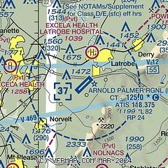
| Sectional chart |
|---|
|
CAUTION: Diagram may not be current
 Download PDF
of official airport diagram from the FAA
| Airport distance calculator |
|---|
|
|
| Sunrise and sunset |
|---|
|
Times for 17-Mar-2025
| | Local
(UTC-4) | | Zulu
(UTC) |
|---|
| Morning civil twilight | | 07:00 | | 11:00 |
| Sunrise | | 07:27 | | 11:27 |
| Sunset | | 19:25 | | 23:25 |
| Evening civil twilight | | 19:52 | | 23:52 |
|
| Current date and time |
|---|
| Zulu (UTC) | 17-Mar-2025 16:22:08 |
|---|
| Local (UTC-4) | 17-Mar-2025 12:22:08 |
|---|
|
| METAR |
|---|
| KLBE | 171545Z 30012KT 10SM OVC018 02/M02 A3012
|
KP53
20nm W | 171556Z AUTO 18010G27KT 01/M08 A3000 RMK AO1 PK WND 17030/1534 SLP169 T00111078 $
|
|
| TAF |
|---|
| KLBE | 171359Z 1714/1812 29010G19KT P6SM OVC020 FM172000 31010G18KT P6SM SCT035 FM180100 00000KT P6SM SKC
|
|
| NOTAMs |
|---|
NOTAMs are issued by the DoD/FAA and will open in a separate window not controlled by AirNav.
|
|


