FAA INFORMATION EFFECTIVE 15 MAY 2025
Location
| FAA Identifier: | LBF |
| Lat/Long: | 41-07-34.3660N 100-41-01.1510W
41-07.572767N 100-41.019183W
41.1262128,-100.6836531
(estimated) |
| Elevation: | 2777 ft. / 846.4 m (surveyed) |
| Variation: | 06E (2015) |
| From city: | 3 miles E of NORTH PLATTE, NE |
| Time zone: | UTC -5 (UTC -6 during Standard Time) |
| Zip code: | 69101 |
Airport Operations
| Airport use: | Open to the public |
| Control tower: | no |
| ARTCC: | DENVER CENTER |
| FSS: | COLUMBUS FLIGHT SERVICE STATION |
| NOTAMs facility: | LBF (NOTAM-D service available) |
| Attendance: | 0600-2300 |
| Pattern altitude: | ALL CAT D ACFT (WITH SPDS OF 141-166 KTS) OPERATING ON RWY 12/30 MUST MNTN A TPA OF 1500 FT WHEN IN THE TFC PAT. |
| Wind indicator: | lighted |
| Segmented circle: | yes |
| Lights: | ACTVT HIRL RWY 12/30; MIRL RWY 17/35; PAPI RWY 12 & 30; VASI RWY 35; MALSR RWY 30 & REIL RWY 35 - CTAF. |
| Beacon: | white-green (lighted land airport)
Operates sunset to sunrise. |
| Fire and rescue: | ARFF index A |
| Airline operations: | PPR 24 HRS FOR UNSKED ACR OPNS WITH MORE THAN 30 PSGR SEATS CALL AMGR 308-530-6948, ARFF INDEX B EQUIP PRVD. |
Airport Communications
| CTAF/UNICOM: | 123.0 |
| WX ASOS: | 118.425 (308-220-0580) |
- APCH/DEP CTL SVC PRVDD BY DENVER ARTCC (ZDV) ON FREQS 132.7/226.675 (NORTH PLATTE RCAG).
- CLEARANCE DELIVERY PRVDD BY DENVER ARTCC ON FREQ 132.7.
Nearby radio navigation aids
| VOR radial/distance | | VOR name | | Freq | | Var |
|---|
| LBFr021/5.5 | | NORTH PLATTE VOR/DME | | 117.40 | | 11E |
| OZBr288/(34.4) | | COZAD VOR | | 109.00 | | 09E |
Airport Services
| Fuel available: | 100LL JET-A |
| Parking: | hangars and tiedowns |
| Airframe service: | MAJOR |
| Powerplant service: | MAJOR |
| Bottled oxygen: | HIGH/LOW |
| Bulk oxygen: | LOW |
Runway Information
Runway 12/30
| Dimensions: | 8001 x 150 ft. / 2439 x 46 m |
| Surface: | concrete/grooved, in excellent condition |
| Weight bearing capacity: | | PCN 33 /R/D/W/T | | Single wheel: | 75.0 | | Double wheel: | 110.0 | | Double tandem: | 190.0 |
|
| Runway edge lights: | high intensity |
| RUNWAY 12 | | RUNWAY 30 |
| Latitude: | 41-07.934520N | | 41-07.162177N |
| Longitude: | 100-41.413403W | | 100-40.002108W |
| Elevation: | 2777.0 ft. | | 2769.0 ft. |
| Traffic pattern: | left | | left |
| Runway heading: | 120 magnetic, 126 true | | 300 magnetic, 306 true |
| Declared distances: | TORA:8001 TODA:8001 ASDA:8001 LDA:8001 | | TORA:8001 TODA:8001 ASDA:8001 LDA:8001 |
| Markings: | precision, in good condition | | precision, in good condition |
| Visual slope indicator: | 4-light PAPI on left (3.00 degrees glide path) | | 4-light PAPI on left (3.00 degrees glide path) |
| Approach lights: | | | MALSR: 1,400 foot medium intensity approach lighting system with runway alignment indicator lights |
| Touchdown point: | yes, no lights | | yes, no lights |
| Instrument approach: | | | ILS |
Runway 17/35
| Dimensions: | 4436 x 100 ft. / 1352 x 30 m |
| Surface: | concrete, in excellent condition |
| Weight bearing capacity: | | PCN 22 /R/B/W/T | | Single wheel: | 28.0 | | Double wheel: | 48.0 | | Double tandem: | 86.0 |
|
| Runway edge lights: | medium intensity |
| RUNWAY 17 | | RUNWAY 35 |
| Latitude: | 41-07.981827N | | 41-07.251537N |
| Longitude: | 100-41.571690W | | 100-41.590240W |
| Elevation: | 2775.7 ft. | | 2774.1 ft. |
| Traffic pattern: | left | | left |
| Runway heading: | 175 magnetic, 181 true | | 355 magnetic, 001 true |
| Displaced threshold: | no | | 301 ft. |
| Declared distances: | TORA:4436 TODA:4436 ASDA:4135 LDA:4135 | | TORA:4436 TODA:4436 ASDA:4436 LDA:4135 |
| Markings: | nonprecision, in good condition | | nonprecision, in good condition |
| Visual slope indicator: | | | 4-box VASI on left (3.00 degrees glide path) |
| Runway end identifier lights: | | | yes |
| Touchdown point: | yes, no lights | | yes, no lights |
| Obstructions: | 21 ft. road, 850 ft. from runway, 30:1 slope to clear | | 27 ft. tree, 675 ft. from runway, 150 ft. left of centerline, 17:1 slope to clear
RWY 35 APCH RATIO 36:1 TO DSPLCD THLD. |
Airport Ownership and Management from official FAA records
| Ownership: | Publicly-owned |
| Owner: | NORTH PLATTE AIRPORT AUTH
PO BOX 1517
NORTH PLATTE, NE 69103
Phone 308-532-1900 |
| Manager: | MR. JUSTIN GOSNELL
5400 E LEE BIRD DR
NORTH PLATTE, NE 69101
Phone 308-532-1900
AFT HRS EMERG, CALL OPNS SUPVR 308-530-6948. |
Additional Remarks
| - | WATERFOWL ON & INVOF ARPT. |
| - | FOR CD CTC DENVER ARTCC ON FREQ. IF UNA, CTC FSS ON FREQ VIA RCO. IF UNA, CTC DENVER ARTCC AT 303-651-4257. |
Instrument Procedures
NOTE: All procedures below are presented as PDF files. If you need a reader for these files, you should download the free Adobe Reader.NOT FOR NAVIGATION. Please procure official charts for flight.
FAA instrument procedures published for use from 15 May 2025 at 0901Z to 13 June 2025 at 0900z.
IAPs - Instrument Approach Procedures |
|---|
| ILS OR LOC RWY 30 | |
download (212KB) |
| RNAV (GPS) RWY 12 | |
download (210KB) |
| RNAV (GPS) RWY 30 | |
download (218KB) |
| RNAV (GPS) RWY 35 | |
download (219KB) |
| VOR RWY 35 | |
download (246KB) |
| NOTE: Special Alternate Minimums apply | |
download (145KB) |
| NOTE: Special Take-Off Minimums/Departure Procedures apply | |
download (360KB) |
Other nearby airports with instrument procedures:
KGTE - Gothenburg Municipal Airport (27 nm SE)
47V - Curtis Municipal Airport (31 nm S)
KCZD - Cozad Municipal Airport (34 nm SE)
KLXN - Jim Kelly Field Airport (46 nm SE)
KOGA - Searle Field Airport (49 nm W)
|
|

Road maps at:
MapQuest
Bing
Google
| Aerial photo |
|---|
WARNING: Photo may not be current or correct
 Photo taken 15-Aug-2005
Do you have a better or more recent aerial photo of North Platte Regional Airport/Lee Bird Field that you would like to share? If so, please send us your photo.
|
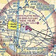
| Sectional chart |
|---|
|
 Download PDF
of official airport diagram from the FAA
| Airport distance calculator |
|---|
|
|
| Sunrise and sunset |
|---|
|
Times for 30-May-2025
| | Local
(UTC-5) | | Zulu
(UTC) |
|---|
| Morning civil twilight | | 05:42 | | 10:42 |
| Sunrise | | 06:14 | | 11:14 |
| Sunset | | 21:06 | | 02:06 |
| Evening civil twilight | | 21:39 | | 02:39 |
|
| Current date and time |
|---|
| Zulu (UTC) | 30-May-2025 05:31:51 |
|---|
| Local (UTC-5) | 30-May-2025 00:31:51 |
|---|
|
| METAR |
|---|
| KLBF | 300453Z AUTO 12005KT 10SM CLR 09/08 A3016 RMK AO2 SLP209 T00940083
|
|
| TAF |
|---|
| KLBF | 291735Z 2918/3018 VRB04KT P6SM BKN050 FM300000 14004KT P6SM SKC FM301500 20005KT P6SM FEW060
|
|
| NOTAMs |
|---|
NOTAMs are issued by the DoD/FAA and will open in a separate window not controlled by AirNav.
|
|


