FAA INFORMATION EFFECTIVE 15 MAY 2025
Location
| FAA Identifier: | LZD |
| Lat/Long: | 41-49-11.1000N 071-54-03.5000W
41-49.185000N 071-54.058333W
41.8197500,-71.9009722
(estimated) |
| Elevation: | 238 ft. / 72.5 m (surveyed) |
| Variation: | 14W (1980) |
| From city: | 2 miles NW of DANIELSON, CT |
| Time zone: | UTC -4 (UTC -5 during Standard Time) |
| Zip code: | 06241 |
Airport Operations
| Airport use: | Open to the public |
| Activation date: | 10/1962 |
| Control tower: | no |
| ARTCC: | BOSTON CENTER |
| FSS: | BRIDGEPORT FLIGHT SERVICE STATION |
| NOTAMs facility: | BDR (NOTAM-D service available) |
| Attendance: | UNATTENDED |
| Wind indicator: | yes |
| Segmented circle: | yes |
| Lights: | ACTVT REIL RWY 31; MIRL RWY 13/31 - CTAF. |
| Beacon: | white-green (lighted land airport)
Operates sunset to sunrise. |
| Landing fee: | no, LDG FEE FOR BUS/CORPORATE & REVENUE PRODUCING ACFT. |
Airport Communications
| CTAF/UNICOM: | 123.0 |
| WX AWOS-3: | 119.125 (860-779-7251) |
| PROVIDENCE APPROACH: | 123.675 |
| PROVIDENCE DEPARTURE: | 123.675 |
| WX ASOS at IJD (13 nm W): | 133.675 (860-456-8839) |
| WX AWOS-3PT at SFZ (19 nm E): | 120.775 (401-334-0324) |
- APCH/DEP SVC PRVDD BY BOSTON ARTCC ON FREQS 124.85/307.9 (WOODSTOCK RCAG) WHEN PROVIDENCE APCH CTL CLSD.
Nearby radio navigation aids
| VOR radial/distance | | VOR name | | Freq | | Var |
|---|
| PUTr211/8.5 | | PUTNAM VOR/DME | | 117.40 | | 14W |
| ORWr030/16.4 | | NORWICH VOR/DME | | 110.00 | | 14W |
| PVDr299/21.9 | | PROVIDENCE VOR/DME | | 115.60 | | 14W |
| GONr027/30.1 | | GROTON VOR/DME | | 110.85 | | 14W |
| HFDr083/30.9 | | HARTFORD VOR/DME | | 114.90 | | 13W |
Airport Services
| Fuel available: | 100LL
100LL:SELF SVC FUEL, CREDIT CARD RQRD: VISA, MASTER-CARD. |
| Parking: | tiedowns |
| Airframe service: | MAJOR |
| Powerplant service: | MAJOR |
| Bottled oxygen: | NONE |
| Bulk oxygen: | NONE |
Runway Information
Runway 13/31
| Dimensions: | 2700 x 75 ft. / 823 x 23 m |
| Surface: | asphalt, in good condition |
| Weight bearing capacity: | |
| Runway edge lights: | medium intensity |
| RUNWAY 13 | | RUNWAY 31 |
| Latitude: | 41-49.294442N | | 41-49.074558N |
| Longitude: | 071-54.316053W | | 071-53.799595W |
| Elevation: | 230.9 ft. | | 233.4 ft. |
| Traffic pattern: | left | | left |
| Runway heading: | 134 magnetic, 120 true | | 314 magnetic, 300 true |
| Markings: | basic, in good condition | | basic, in good condition |
| Runway end identifier lights: | no | | yes |
| Touchdown point: | yes, no lights | | yes, no lights |
| Obstructions: | 27 ft. tree, 509 ft. from runway, 155 ft. left of centerline, 11:1 slope to clear | | 90 ft. tree, 1550 ft. from runway, 280 ft. left of centerline, 14:1 slope to clear |
Airport Ownership and Management from official FAA records
| Ownership: | Publicly-owned |
| Owner: | CONNECTICUT AIRPORT AUTHORITY
SUITE 160, 334 ELLA GRASSO TURNPIKE
WINDSOR LOCKS, CT 06096
Phone 860-386-6000 |
| Manager: | ROBERT PELLEGRINO
CONNECTICUT AIRPORT AUTHORITY, 239 MAXIM RD
HARTFORD, CT 06114
Phone 860-982-2443 |
Additional Remarks
| - | DEER ON & INVOF ARPT. |
| - | FOR CD CTC PROVIDENCE APCH AT 401-738-8945, WHEN APCH CLSD CTC BOSTON ARTCC AT 603-879-6859. |
Instrument Procedures
NOTE: All procedures below are presented as PDF files. If you need a reader for these files, you should download the free Adobe Reader.NOT FOR NAVIGATION. Please procure official charts for flight.
FAA instrument procedures published for use from 15 May 2025 at 0901Z to 13 June 2025 at 0900z.
IAPs - Instrument Approach Procedures |
|---|
| VOR-A | |
download (176KB) |
| NOTE: Special Take-Off Minimums/Departure Procedures apply | |
download (292KB) |
Other nearby airports with instrument procedures:
KIJD - Windham Airport (13 nm W)
3B0 - Southbridge Municipal Airport (18 nm N)
KSFZ - North Central State Airport (19 nm E)
KPVD - Rhode Island TF Green International Airport (22 nm E)
1B6 - Hopedale Industrial Park Airport (24 nm NE)
|
|

Road maps at:
MapQuest
Bing
Google
| Aerial photo |
|---|
WARNING: Photo may not be current or correct
 Photo by Karl Swenson
Photo taken 22-Oct-2010
looking northwest from 4500 feet.
Photo by Karl Swenson
Photo taken 22-Oct-2010
looking northwest from 4500 feet.
Do you have a better or more recent aerial photo of Danielson Airport that you would like to share? If so, please send us your photo.
|
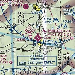
| Sectional chart |
|---|
|
| Airport distance calculator |
|---|
|
|
| Sunrise and sunset |
|---|
|
Times for 24-May-2025
| | Local
(UTC-4) | | Zulu
(UTC) |
|---|
| Morning civil twilight | | 04:48 | | 08:48 |
| Sunrise | | 05:21 | | 09:21 |
| Sunset | | 20:08 | | 00:08 |
| Evening civil twilight | | 20:41 | | 00:41 |
|
| Current date and time |
|---|
| Zulu (UTC) | 25-May-2025 03:12:28 |
|---|
| Local (UTC-4) | 24-May-2025 23:12:28 |
|---|
|
| METAR |
|---|
KIJD
13nm W | 250252Z AUTO 26004KT 10SM SCT060 BKN100 11/07 A2996 RMK AO2 SLP146 60000 T01060072 50011
|
KSFZ
19nm E | 250256Z AUTO 26003KT 10SM FEW045 OVC055 10/08 A2994 RMK AO2 SLP140 T01000083 51008 $
|
KPVD
22nm E | 250251Z 27005KT 10SM BKN060 BKN100 12/07 A2995 RMK AO2 SLP141 T01170067 51011 $
|
KOQU
25nm SE | 250255Z AUTO 28009KT 10SM FEW060 OVC100 13/09 A2994 RMK AO2
|
|
| TAF |
|---|
KPVD
22nm E | 242026Z 2420/2518 31011G19KT P6SM VCSH BKN035 TEMPO 2421/2423 5SM -SHRA BKN030 FM250000 30008KT P6SM BKN060 FM251500 31010G20KT P6SM BKN035
|
KORH
27nm N | 241727Z 2418/2518 29010G20KT P6SM FEW030 BKN035 TEMPO 2421/2422 4SM -SHRA OVC025 FM250200 29006KT P6SM BKN040 FM251400 31008G18KT P6SM BKN030 FM251600 31011G21KT P6SM BKN035
|
|
| NOTAMs |
|---|
NOTAMs are issued by the DoD/FAA and will open in a separate window not controlled by AirNav.
|
|


