FAA INFORMATION EFFECTIVE 15 MAY 2025
Location
| FAA Identifier: | MJX |
| Lat/Long: | 39-55-33.7500N 074-17-43.9250W
39-55.562500N 074-17.732083W
39.9260417,-74.2955347
(estimated) |
| Elevation: | 86 ft. / 26.2 m (surveyed) |
| Variation: | 13W (2015) |
| From city: | 5 miles SW of TOMS RIVER, NJ |
| Time zone: | UTC -4 (UTC -5 during Standard Time) |
| Zip code: | 08731 |
Airport Operations
| Airport use: | Open to the public |
| Control tower: | no |
| ARTCC: | NEW YORK CENTER |
| FSS: | MILLVILLE FLIGHT SERVICE STATION |
| NOTAMs facility: | MJX (NOTAM-D service available) |
| Attendance: | NOV - MAR 0800-1700, APR - OCT 0800-2000
UNATNDD CHRISTMAS & NEW YEARS DAY. PREARRANGE FOR SVCS AFT HRS CALL 732-797-1077. |
| Wind indicator: | lighted |
| Segmented circle: | yes |
| Lights: | ACTVT MALSR RWY 06; REIL RWY 14, 32 & 24; PAPI RWY 06, 24, 14 & 32; HIRL RWY 06/24; MIRL RWY 14/32 - CTAF. |
| Beacon: | white-green (lighted land airport)
Operates sunset to sunrise. |
Airport Communications
| CTAF/UNICOM: | 122.7 |
| WX AWOS-3PT: | 119.875 (732-797-2542) |
| MC GUIRE APPROACH: | 126.475 |
| MC GUIRE DEPARTURE: | 126.475 |
| WAALK STAR: | 124.6 |
| WX AWOS-AV at N12 (10 nm NE): | 122.8 (732-363-6471) |
| WX AWOS-3PT at BLM (18 nm NE): | 121.625 (732-938-3330) |
Nearby radio navigation aids
| VOR radial/distance | | VOR name | | Freq | | Var |
|---|
| CYNr054/9.0 | | COYLE VORTAC | | 113.40 | | 10W |
| GXUr122/14.7 | | MC GUIRE VORTAC | | 110.60 | | 12W |
| RBVr161/18.9 | | ROBBINSVILLE VORTAC | | 113.80 | | 10W |
| COLr206/24.0 | | COLTS NECK VOR/DME | | 115.40 | | 11W |
| ACYr035/31.0 | | ATLANTIC CITY VORTAC | | 117.15 | | 10W |
| ARDr135/34.3 | | YARDLEY VOR/DME | | 108.20 | | 10W |
| VCNr063/38.8 | | CEDAR LAKE VOR/DME | | 115.20 | | 10W |
| NDB name | | Hdg/Dist | | Freq | | Var | | ID |
|---|
| LAKEHURST | | 177/7.4 | | 396 | | 11W | | NEL | -. . .-.. |
Airport Services
| Fuel available: | 100LL JET-A |
| Parking: | hangars and tiedowns |
| Airframe service: | MAJOR |
| Powerplant service: | MAJOR |
| Bottled oxygen: | HIGH |
| Bulk oxygen: | NONE |
Runway Information
Runway 6/24
| Dimensions: | 5950 x 100 ft. / 1814 x 30 m |
| Surface: | asphalt, in good condition |
| Weight bearing capacity: | | PCN 45 /F/A/X/T | | Single wheel: | 100.0 | | Double wheel: | 176.0 | | Double tandem: | 581.0 |
|
| Runway edge lights: | high intensity |
| RUNWAY 6 | | RUNWAY 24 |
| Latitude: | 39-55.334177N | | 39-55.965910N |
| Longitude: | 074-18.029490W | | 074-17.056260W |
| Elevation: | 75.7 ft. | | 75.8 ft. |
| Traffic pattern: | left | | left |
| Runway heading: | 063 magnetic, 050 true | | 243 magnetic, 230 true |
| Displaced threshold: | no | | 115 ft. |
| Declared distances: | TORA:5950 TODA:5950 ASDA:5835 LDA:5835 | | TORA:5950 TODA:5950 ASDA:5950 LDA:5835 |
| Markings: | precision, in fair condition | | precision, in fair condition |
| Visual slope indicator: | 2-light PAPI on left (3.00 degrees glide path) | | 2-light PAPI on left (3.00 degrees glide path) |
| Approach lights: | MALSR: 1,400 foot medium intensity approach lighting system with runway alignment indicator lights | | |
| Runway end identifier lights: | | | yes |
| Touchdown point: | yes, no lights | | yes, no lights |
| Instrument approach: | ILS | | |
Runway 14/32
| Dimensions: | 3599 x 75 ft. / 1097 x 23 m |
| Surface: | asphalt, in good condition |
| Weight bearing capacity: | | PCN 35 /F/A/X/T | | Single wheel: | 94.0 | | Double wheel: | 150.0 |
|
| Runway edge lights: | medium intensity |
| RUNWAY 14 | | RUNWAY 32 |
| Latitude: | 39-55.601138N | | 39-55.234317N |
| Longitude: | 074-18.347252W | | 074-17.742370W |
| Elevation: | 86.0 ft. | | 75.9 ft. |
| Traffic pattern: | left | | left |
| Runway heading: | 141 magnetic, 128 true | | 321 magnetic, 308 true |
| Markings: | basic, in good condition | | basic, in good condition |
| Visual slope indicator: | 2-light PAPI on left (3.00 degrees glide path) | | 2-light PAPI on left (3.00 degrees glide path) |
| Runway end identifier lights: | yes | | yes |
| Touchdown point: | yes, no lights | | yes, no lights |
Helipad H1
| Dimensions: | 100 x 100 ft. / 30 x 30 m |
| Surface: | asphalt, in good condition |
| Operational restrictions: | FATO 100X100 FT |
| Latitude: | 39-55.577000N | | |
| Longitude: | 074-17.835500W | | |
| Elevation: | 83.4 ft. | | |
| Traffic pattern: | left | | left |
Airport Ownership and Management from official FAA records
| Ownership: | Publicly-owned |
| Owner: | COUNTY OF OCEAN
101 HOOPER AVENUE, PO BOX 2191
TOMS RIVER, NJ 08754-2191
Phone 732-929-2054 |
| Manager: | ANTHONY AGLIATA
129 HOOPER AVENUE, PO BOX 2191
TOMS RIVER, NJ 08754-2191
Phone (732) 929-2054 |
Additional Remarks
| - | DEER & BIRDS ON & INVOF ARPT. |
| - | FOR CD CTC MC GUIRE APCH AT 609-754-2767. |
Instrument Procedures
NOTE: All procedures below are presented as PDF files. If you need a reader for these files, you should download the free Adobe Reader.NOT FOR NAVIGATION. Please procure official charts for flight.
FAA instrument procedures published for use from 15 May 2025 at 0901Z to 13 June 2025 at 0900z.
STARs - Standard Terminal Arrivals |
|---|
| WAALK TWO (RNAV) | |
2 pages:
[1] [2] (286KB) |
IAPs - Instrument Approach Procedures |
|---|
| ILS OR LOC RWY 06 | |
download (363KB) |
| RNAV (GPS) RWY 06 | |
download (306KB) |
| RNAV (GPS) RWY 24 | |
download (212KB) |
| VOR RWY 06 | |
download (340KB) |
| VOR RWY 24 | |
download (210KB) |
| NOTE: Special Take-Off Minimums/Departure Procedures apply | |
download (267KB) |
Other nearby airports with instrument procedures:
KNEL - Lakehurst Maxfield Field Airport (7 nm N)
N12 - Lakewood Airport (10 nm NE)
KWRI - McGuire Field (Joint Base Mc Guire Dix Lakehurst) Airport (15 nm W)
31E - Eagles Nest Airport (16 nm S)
KBLM - Monmouth Executive Airport (18 nm NE)
|
|

Road maps at:
MapQuest
Bing
Google
| Aerial photo |
|---|
WARNING: Photo may not be current or correct
 Photo by Serena OSullivan
Photo taken 26-Feb-2018
looking east.
Photo by Serena OSullivan
Photo taken 26-Feb-2018
looking east.
Do you have a better or more recent aerial photo of Ocean County Airport that you would like to share? If so, please send us your photo.
|
| Sectional chart |
|---|
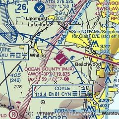
|
| Airport distance calculator |
|---|
|
|
| Sunrise and sunset |
|---|
|
Times for 01-Jun-2025
| | Local
(UTC-4) | | Zulu
(UTC) |
|---|
| Morning civil twilight | | 05:00 | | 09:00 |
| Sunrise | | 05:32 | | 09:32 |
| Sunset | | 20:18 | | 00:18 |
| Evening civil twilight | | 20:50 | | 00:50 |
|
| Current date and time |
|---|
| Zulu (UTC) | 01-Jun-2025 22:53:07 |
|---|
| Local (UTC-4) | 01-Jun-2025 18:53:07 |
|---|
|
| METAR |
|---|
| KMJX | AWOS-3 119.875 732-244-4450
012156Z AUTO 26007KT 10SM BKN075 20/06 A2981 RMK AO2 SLP097 T02000056
|
KWRI
14nm W | 012155Z 26008KT 10SM CLR 20/05 A2978 RMK AO2A SLP084 T01950048
|
KBLM
17nm NE | AWOS-3 121.625 732-938-3330
011702Z 28008G19KT 10SM BKN060 19/05 A2976
|
|
| TAF |
|---|
KWRI
14nm W | 011800Z 0118/0224 28015G25KT 9999 SCT055 QNH2975INS BECMG 0120/0121 27008KT 9999 FEW055 SCT060 QNH2979INS BECMG 0204/0205 27006KT 9999 FEW080 QNH2990INS TX22/0120Z TN10/0210Z
|
|
| NOTAMs |
|---|
NOTAMs are issued by the DoD/FAA and will open in a separate window not controlled by AirNav.
|
|


