FAA INFORMATION EFFECTIVE 16 APRIL 2026
Location
| FAA Identifier: | BLM |
| Lat/Long: | 40-11-12.4000N 074-07-28.4000W
40-11.206667N 074-07.473333W
40.1867778,-74.1245556
(estimated) |
| Elevation: | 153.4 ft. / 46.8 m (surveyed) |
| Variation: | 12W (1985) |
| From city: | 5 miles W of central business district of the associated city |
| Time zone: | UTC -4 (UTC -5 during Standard Time) |
| Zip code: | 07727 |
Airport Operations
| Airport use: | Open to the public |
| Activation date: | 03/1946 |
| Control tower: | no |
| ARTCC: | NEW YORK CENTER |
| FSS: | MILLVILLE FLIGHT SERVICE STATION |
| NOTAMs facility: | BLM (NOTAM-D service available) |
| Attendance: | CONTINUOUS |
| Wind indicator: | lighted |
| Segmented circle: | no |
| Lights: | SS-SR |
| Beacon: | white-green (lighted land airport)
Operates sunset to sunrise. |
| Landing fee: | yes |
Airport Communications
| CTAF/UNICOM: | 123.0 |
| WX AWOS-3PT: | 121.625 (732-938-3330) |
| MC GUIRE APPROACH: | 126.475 |
| MC GUIRE DEPARTURE: | 126.475 |
| CLEARANCE DELIVERY: | 126.15 |
| WX AWOS-AV at N12 (8 nm S): | 122.8 (732-363-6471) |
| WX AWOS-3PT at MJX (18 nm SW): | 119.875 (732-797-2542) |
Nearby radio navigation aids
| VOR radial/distance | | VOR name | | Freq | | Var |
|---|
| COLr179/7.7 | | COLTS NECK VOR/DME | | 115.40 | | 11W |
| RBVr103/17.0 | | ROBBINSVILLE VORTAC | | 113.80 | | 10W |
| GXUr076/24.1 | | MC GUIRE VORTAC | | 110.60 | | 12W |
| CYNr042/26.3 | | COYLE VORTAC | | 113.40 | | 10W |
| CRIr213/27.6 | | CANARSIE VOR/DME | | 112.30 | | 11W |
| JFKr223/31.3 | | KENNEDY VOR/DME | | 115.90 | | 12W |
| ARDr106/36.1 | | YARDLEY VOR/DME | | 108.20 | | 10W |
| SBJr140/36.9 | | SOLBERG VOR/DME | | 112.90 | | 10W |
| LGAr210/37.7 | | LA GUARDIA VOR/DME | | 113.10 | | 12W |
| TEBr195/39.8 | | TETERBORO VOR/DME | | 108.40 | | 11W |
| NDB name | | Hdg/Dist | | Freq | | Var | | ID |
|---|
| LAKEHURST | | 060/12.9 | | 396 | | 11W | | NEL | -. . .-.. |
Airport Services
| Fuel available: | 100LL JET-A
A:JET A AVBL 24 HRS.
100LL:SELF-SVC 100LL AVABL 24 HRS. |
| Parking: | hangars and tiedowns |
| Airframe service: | MINOR |
| Powerplant service: | MINOR |
| Bottled oxygen: | NONE |
| Bulk oxygen: | NONE |
Runway Information
Runway 14/32
| Dimensions: | 7345 x 85 ft. / 2239 x 26 m
RWY 14/32 FIRST 575 FT AT AER 32 85 FT WIDE; REMAINDER RWY 14/32 100 FT WIDE |
| Surface: | asphalt, in good condition |
| Runway edge lights: | non-standard
RWY 14/32 NSTD MIRLS; RWY 32 THLD LGTS NTSD. |
| RUNWAY 14 | | RUNWAY 32 |
| Latitude: | 40-11.663285N | | 40-10.847027N |
| Longitude: | 074-08.125498W | | 074-06.961473W |
| Elevation: | 109.9 ft. | | 152.6 ft. |
| Traffic pattern: | left | | left |
| Runway heading: | 144 magnetic, 132 true | | 324 magnetic, 312 true |
| Markings: | precision, in good condition | | NSTD, in good condition |
| Runway end identifier lights: | yes | | no |
| Touchdown point: | yes, no lights | | yes, no lights |
| Instrument approach: | LOC/DME | | |
| Obstructions: | 30 ft. trees, 807 ft. from runway, 243 ft. left of centerline, 20:1 slope to clear
OBSTN CLNC SLOPE 20:1 TO THRESHOLD | | 27 ft. trees, 774 ft. from runway, 20:1 slope to clear
OBSTN CLNC SLOPE 20:1 TO THRESHOLD |
Runway 3/21
| Dimensions: | 3508 x 50 ft. / 1069 x 15 m |
| Surface: | asphalt, in good condition |
| Weight bearing capacity: | | Single wheel: | RWY 03/21 CLSD TO ACFT OVER 12500 LBS. |
|
| RUNWAY 3 | | RUNWAY 21 |
| Latitude: | 40-10.835645N | | 40-11.372248N |
| Longitude: | 074-07.467943W | | 074-07.188895W |
| Elevation: | 148.7 ft. | | 146.9 ft. |
| Traffic pattern: | left | | left |
| Runway heading: | 034 magnetic, 022 true | | 214 magnetic, 202 true |
| Markings: | basic, in good condition | | basic, in good condition |
| Touchdown point: | yes, no lights | | yes, no lights |
| Obstructions: | 43 ft. trees, 473 ft. from runway, 6:1 slope to clear
+15 FT TREE 138 FT FM RWY END 13 FT R CNTRLN. | | 29 ft. tree, 210 ft. from runway, 75 ft. right of centerline
RWY 21 32 FT POLE/BLDG 60 FT FROM THLD, 70 FT LEFT. |
Airport Ownership and Management from official FAA records
| Ownership: | Privately-owned |
| Owner: | WALL AVIATION
1717 STATE RD 34, BLDG 5
FARMINGDALE, NJ 07727
Phone 732-938-4800 |
| Manager: | ALAN ANTAKI
1717 STATE RD 34, BLDG 5
FARMINGDALE, NJ 07727
Phone 732-751-0044 |
Additional Remarks
| - | NO HELICOPTER ACTIVITY NE OF RY 14. HELICOPTER INSTRUCTION BY PRE-ARRANGEMENT ONLY 732-938-4800. |
| - | FOR CD CTC MC GUIRE APCH VIA FREQ, IF UNA CALL 609-754-2767. |
| - | ALL TSNT ACFT MUST GO TO FBO ON WEST SIDE OF ARPT. |
| - | NO TOUCH & GO LANDINGS FRI; SAT; SUN. |
| - | DEER & BIRDS ON & INVOF ARPT. |
| - | RY 14/32 NON-STD TWY SEPARATION 185 FT. |
| - | BERM 36 FT HIGH; NORTH RY 14/32 65 FT FROM CNTRLN. |
| - | TWYS NSTD MARKINGS. RY HOLD MARKINGS ON TWYS NSTD PLACEMENT. TWY LINES DO NOT ENSURE WING TIP/ROTOR CLEARANCE AT NW END OF PARALLEL TWY. |
Instrument Procedures
NOTE: All procedures below are presented as PDF files. If you need a reader for these files, you should download the free Adobe Reader.NOT FOR NAVIGATION. Please procure official charts for flight.
FAA instrument procedures published for use from 16 April 2026 at 0901Z to 14 May 2026 at 0900Z.
STARs - Standard Terminal Arrivals |
|---|
| WAALK TWO (RNAV) | |
2 pages:
[1] [2] (288KB) |
IAPs - Instrument Approach Procedures |
|---|
| RNAV (GPS) RWY 14 | |
download (239KB) |
| RNAV (GPS) RWY 32 | |
download (239KB) |
| RNAV (GPS) Z RWY 14 | |
download (236KB) |
| RNAV (GPS) Z RWY 32 | |
download (238KB) |
| VOR-A | |
download (228KB) |
| NOTE: Special Alternate Minimums apply | |
download (144KB) |
| NOTE: Special Take-Off Minimums/Departure Procedures apply | |
download (442KB) |
Other nearby airports with instrument procedures:
N12 - Lakewood Airport (8 nm S)
3N6 - Old Bridge Airport (13 nm NW)
KNEL - Lakehurst Maxfield Field Airport (14 nm SW)
KMJX - Ocean County Airport (18 nm SW)
N87 - Trenton-Robbinsville Airport (22 nm W)
|
|

Road maps at:
MapQuest
Bing
Google
| Aerial photo |
|---|
WARNING: Photo may not be current or correct
 Photo by John Hannon
Photo taken 12-May-2014
looking northwest.
Photo by John Hannon
Photo taken 12-May-2014
looking northwest.
Do you have a better or more recent aerial photo of Monmouth Executive Airport that you would like to share? If so, please send us your photo.
|
| Sectional chart |
|---|
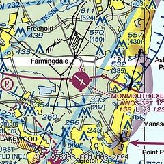
|
| Airport distance calculator |
|---|
|
|
| Sunrise and sunset |
|---|
|
Times for 11-May-2026
| | Local
(UTC-4) | | Zulu
(UTC) |
|---|
| Morning civil twilight | | 05:15 | | 09:15 |
| Sunrise | | 05:46 | | 09:46 |
| Sunset | | 20:00 | | 00:00 |
| Evening civil twilight | | 20:30 | | 00:30 |
|
| Current date and time |
|---|
| Zulu (UTC) | 11-May-2026 10:17:39 |
|---|
| Local (UTC-4) | 11-May-2026 06:17:39 |
|---|
|
| METAR |
|---|
| KBLM | AWOS-3 121.625 732-938-3330
110956Z AUTO 34005KT 10SM OVC042 11/07 A3011 RMK AO2 SLP195 T01110067 PNO $
|
KMJX
17nm SW | AWOS-3 119.875 732-244-4450
110956Z AUTO 00000KT 10SM OVC038 11/09 A3010 RMK AO2 RAB0858E17 SLP198 T01060089 PNO $
|
|
| TAF |
|---|
KWRI
23nm SW | 110200Z 1102/1208 31006KT 6000 -SHRA BKN020 BKN060 QNH3000INS BECMG 1104/1105 01008KT 6000 -SHRA BKN020 BKN040 QNH3003INS BECMG 1108/1109 03010G15KT 9999 NSW SCT040 SCT120 QNH3008INS BECMG 1116/1117 29006KT 9999 VCSH FEW060 SCT160 QNH3013INS BECMG 1121/1122 VRB03KT 9999 NSW FEW080 QNH3007INS TX14/1120Z TN11/1110Z
|
|
| NOTAMs |
|---|
NOTAMs are issued by the DoD/FAA and will open in a separate window not controlled by AirNav.
|
|


