FAA INFORMATION EFFECTIVE 15 MAY 2025
Location
| FAA Identifier: | MPO |
| Lat/Long: | 41-08-15.7000N 075-22-48.2000W
41-08.261667N 075-22.803333W
41.1376944,-75.3800556
(estimated) |
| Elevation: | 1915.2 ft. / 583.8 m (surveyed) |
| Variation: | 13W (2005) |
| From city: | 2 miles NW of MOUNT POCONO, PA |
| Time zone: | UTC -4 (UTC -5 during Standard Time) |
| Zip code: | 18346 |
Airport Operations
| Airport use: | Open to the public |
| Activation date: | 07/1938 |
| Control tower: | no |
| ARTCC: | NEW YORK CENTER |
| FSS: | WILLIAMSPORT FLIGHT SERVICE STATION |
| NOTAMs facility: | MPO (NOTAM-D service available) |
| Attendance: | 0700-1700 |
| Wind indicator: | lighted |
| Segmented circle: | yes |
| Lights: | ACTVT REIL RWY 05, 13, 23 & 31; PAPI RWY 05, 13, 23 & 31; MIRL RWY 05/23 & 13/31 - CTAF. |
| Beacon: | white-green (lighted land airport)
Operates sunset to sunrise. |
Airport Communications
| CTAF/UNICOM: | 122.7 |
| WX ASOS: | 120.275 (570-839-1584) |
| WILKES-BARRE APPROACH: | 126.3 |
| WILKES-BARRE DEPARTURE: | 126.3 |
| CLEARANCE DELIVERY: | 125.3 |
| WX ASOS at AVP (20 nm NW): | PHONE 570-456-5433 |
Nearby radio navigation aids
| VOR radial/distance | | VOR name | | Freq | | Var |
|---|
| LVZr130/16.1 | | WILKES-BARRE VORTAC | | 111.60 | | 10W |
| STWr301/24.6 | | STILLWATER VOR/DME | | 109.60 | | 11W |
| FJCr018/24.9 | | ALLENTOWN VORTAC | | 117.50 | | 10W |
| BWZr320/32.5 | | BROADWAY VOR/DME | | 114.20 | | 11W |
| ETXr031/36.1 | | EAST TEXAS VOR/DME | | 110.20 | | 09W |
| SAXr287/38.3 | | SPARTA VORTAC | | 115.70 | | 11W |
| HUOr256/39.1 | | HUGUENOT VOR/DME | | 116.10 | | 11W |
Airport Services
| Fuel available: | 100LL JET-A
100LL:24 HR SELF SVC 100LL AVAIL. |
| Parking: | hangars and tiedowns |
| Airframe service: | MAJOR |
| Powerplant service: | MAJOR |
| Bottled oxygen: | NONE |
| Bulk oxygen: | NONE |
Runway Information
Runway 13/31
| Dimensions: | 5001 x 75 ft. / 1524 x 23 m |
| Surface: | asphalt, in excellent condition |
| Weight bearing capacity: | | Single wheel: | 30.0 | | Double wheel: | 45.0 |
|
| Runway edge lights: | medium intensity |
| RUNWAY 13 | | RUNWAY 31 |
| Latitude: | 41-08.400830N | | 41-08.050890N |
| Longitude: | 075-23.432435W | | 075-22.446467W |
| Elevation: | 1884.9 ft. | | 1878.2 ft. |
| Traffic pattern: | left | | left |
| Runway heading: | 128 magnetic, 115 true | | 308 magnetic, 295 true |
| Displaced threshold: | 501 ft. | | no |
| Markings: | nonprecision, in good condition | | nonprecision, in good condition |
| Visual slope indicator: | 2-light PAPI on left (3.00 degrees glide path) | | 2-light PAPI on left (3.50 degrees glide path)
VGSI AND RNAV GLIDEPATH NOT COINCIDENT. |
| Runway end identifier lights: | yes | | yes |
| Touchdown point: | yes, no lights | | yes, no lights |
| Obstructions: | 44 ft. trees, 671 ft. from runway, 284 ft. right of centerline, 10:1 slope to clear
26:1 SLP TO DTHR. | | 102 ft. trees, 2921 ft. from runway, 200 ft. left and right of centerline, 26:1 slope to clear |
Runway 5/23
| Dimensions: | 3999 x 100 ft. / 1219 x 30 m |
| Surface: | asphalt, in good condition |
| Weight bearing capacity: | | Single wheel: | 30.0 | | Double wheel: | 45.0 | | Double tandem: | 70.0 |
|
| Runway edge lights: | medium intensity |
| RUNWAY 5 | | RUNWAY 23 |
| Latitude: | 41-08.042782N | | 41-08.570645N |
| Longitude: | 075-22.892863W | | 075-22.372260W |
| Elevation: | 1874.7 ft. | | 1915.2 ft. |
| Traffic pattern: | left | | left |
| Runway heading: | 050 magnetic, 037 true | | 230 magnetic, 217 true |
| Markings: | nonprecision, in good condition | | nonprecision, in good condition |
| Visual slope indicator: | 2-light PAPI on left (4.00 degrees glide path) | | 2-light PAPI on left (4.00 degrees glide path) |
| Runway end identifier lights: | yes | | yes |
| Touchdown point: | yes, no lights | | yes, no lights |
| Obstructions: | 26 ft. trees, 599 ft. from runway, 149 ft. left of centerline, 15:1 slope to clear | | 37 ft. road, lighted, 733 ft. from runway, 14:1 slope to clear |
Airport Ownership and Management from official FAA records
| Ownership: | Publicly-owned |
| Owner: | POCONO MTNS MUNI ARPT AUTH
188 AIRPORT DR
TOBYHANNA, PA 18466
Phone 570-839-0258 |
| Manager: | JUSTIN KLEIN
188 AIRPORT DR
TOBYHANNA, PA 18466
Phone (570) 839-0258 |
Additional Remarks
| - | BIRDS, DEER & OTHER WILDLIFE ON & INVOF ARPT. |
| - | RWY 31 VFR DEP: FLY HDG 310 TILL CROSSING INTERSTATE 380, THEN PROCEED ON CRS AVOIDING OVERFLIGHT OF HOMES SW OF RWY 13-31. |
| - | FOR SVC AFT HRS CALL 570-807-8966. |
Instrument Procedures
NOTE: All procedures below are presented as PDF files. If you need a reader for these files, you should download the free Adobe Reader.NOT FOR NAVIGATION. Please procure official charts for flight.
FAA instrument procedures published for use from 15 May 2025 at 0901Z to 13 June 2025 at 0900z.
IAPs - Instrument Approach Procedures |
|---|
| RNAV (GPS) RWY 05 | |
download (277KB) |
| RNAV (GPS) RWY 13 | |
download (268KB) |
| RNAV (GPS) RWY 31 | |
download (284KB) |
| VOR/DME RWY 13 | |
download (213KB) |
| NOTE: Special Alternate Minimums apply | |
download (123KB) |
| NOTE: Special Take-Off Minimums/Departure Procedures apply | |
download (428KB) |
Other nearby airports with instrument procedures:
KAVP - Wilkes-Barre/Scranton International Airport (20 nm NW)
1N7 - Blairstown Airport (20 nm SE)
KWBW - Wilkes-Barre Wyoming Valley Airport (23 nm NW)
N30 - Cherry Ridge Airport (23 nm N)
N43 - Braden Airpark (25 nm S)
|
|

Road maps at:
MapQuest
Bing
Google
| Aerial photo |
|---|
WARNING: Photo may not be current or correct

Do you have a better or more recent aerial photo of Pocono Mountains Regional Airport that you would like to share? If so, please send us your photo.
|
| Sectional chart |
|---|
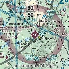
|
| Airport distance calculator |
|---|
|
|
| Sunrise and sunset |
|---|
|
Times for 20-May-2025
| | Local
(UTC-4) | | Zulu
(UTC) |
|---|
| Morning civil twilight | | 05:08 | | 09:08 |
| Sunrise | | 05:40 | | 09:40 |
| Sunset | | 20:16 | | 00:16 |
| Evening civil twilight | | 20:48 | | 00:48 |
|
| Current date and time |
|---|
| Zulu (UTC) | 20-May-2025 16:08:01 |
|---|
| Local (UTC-4) | 20-May-2025 12:08:01 |
|---|
|
| METAR |
|---|
| KMPO | 201553Z AUTO 32014G19KT 10SM FEW022 09/02 A2996 RMK AO2 SLP155 T00940022
|
KAVP
20nm NW | 201554Z AUTO 34010KT 10SM OVC028 09/02 A3002 RMK AO2 SLP166 T00940022 $
|
|
| TAF |
|---|
KAVP
20nm NW | 201358Z 2014/2112 35008G21KT P6SM BKN019 FM201500 35009G20KT P6SM SCT035 FM210100 00000KT P6SM BKN100 FM210900 12006G14KT P6SM BKN030 FM211100 12007G16KT P6SM -SHRA OVC018
|
|
| NOTAMs |
|---|
NOTAMs are issued by the DoD/FAA and will open in a separate window not controlled by AirNav.
|
|


