FAA INFORMATION EFFECTIVE 22 JANUARY 2026
Location
| FAA Identifier: | NUQ |
| Lat/Long: | 37-24-58.1180N 122-02-56.8650W
37-24.968633N 122-02.947750W
37.4161439,-122.0491292
(estimated) |
| Elevation: | 36.9 ft. / 11 m (estimated) |
| Variation: | 16E (1980) |
| From city: | 3 miles N of MOUNTAIN VIEW, CA |
| Time zone: | UTC -8 (UTC -7 during Daylight Saving Time) |
| Zip code: | 94043 |
Airport Operations
| Airport use: | Private use. Permission required prior to landing |
| Control tower: | yes |
| ARTCC: | OAKLAND CENTER |
| FSS: | OAKLAND FLIGHT SERVICE STATION
FSS-OAKLAND OAK-NOTAM NUQ |
| NOTAMs facility: | NUQ (NOTAM-D service available) |
| Attendance: | CONTINUOUS |
| Pattern altitude: | 1004(968) RWY 14L/R, 1504(1468) RWY 32L/R. MIN ALT 75' AGL OVER HWY AT SOUTH BDRY. TRAN PRACTICE APCH/TGL RQRS ARPT MGR APVL. |
| Wind indicator: | lighted |
| Segmented circle: | yes |
| Lights: | WHEN TWR CLSD, ACTVT REIL RWY 14L; MALSR RWY 32R; PAPI RWY 14L & 32R; HIRL RWY 14L/32R & 14R/32L- CTAF. |
| Beacon: | white-green (lighted land airport)
Operates sunset to sunrise. |
| International operations: | customs landing rights airport |
Airport Communications
| CTAF: | 119.55 |
| ATIS: | 124.175 283.0 |
| WX AWOS-3PT: | 124.175 (650-386-0655) |
| MOFFETT GROUND: | 121.85 278.95 [1500-0700Z++] |
| MOFFETT TOWER: | 119.55 259.65 [1500-0700Z++] |
| NORCAL APPROACH: | 120.1 135.2 133.95 134.5 |
| NORCAL DEPARTURE: | 120.1 |
| CLEARANCE DELIVERY: | 296.75 |
| ALCP: | 349.4 |
| EMERG: | 121.5 243.0 |
| IC: | 120.1 |
| PMSV METRO: | 341.3 |
| SFA: | 134.1 |
| WOODSIDE DP: | 121.3 |
| WX ASOS at SJC (7 nm SE): | PHONE 408-969-0838 |
| WX AWOS-3P at SQL (11 nm NW): | 125.9 (650-593-0613) |
| WX ASOS at HWD (15 nm N): | PHONE 510-786-3052 |
| WX ASOS at SFO (20 nm NW): | PHONE 650-250-5841 |
| WX ASOS at LVK (20 nm NE): | PHONE 925-606-5412 |
- ATCT OPER BY AIR NATIONAL GUARD.
- COMMUNICATIONS: ANG - OPR 1400-2330Z++. 390.9 5711 REMARKS: SQ OPS, CALL MOFFETT RESCUE. (5711 USB).
Nearby radio navigation aids
| VOR radial/distance | | VOR name | | Freq | | Var |
|---|
| SJCr281/5.6 | | SAN JOSE VOR/DME | | 114.10 | | 16E |
| OSIr066/11.2 | | WOODSIDE VOR/DME | | 113.90 | | 17E |
| SFOr111/19.7 | | SAN FRANCISCO VOR/DME | | 115.80 | | 17E |
| OAKr139/20.4 | | OAKLAND VOR/DME | | 116.80 | | 17E |
| SAUr123/34.7 | | SAUSALITO VOR/DME | | 116.20 | | 17E |
| CCRr163/37.7 | | CONCORD VOR/DME | | 117.00 | | 17E |
Airport Services
| Fuel available: | A
A:JET A AVAIL 24 HRS. |
| Parking: | tiedowns |
| Airframe service: | NONE |
| Powerplant service: | NONE |
| Bottled oxygen: | NONE |
| Bulk oxygen: | NONE |
Runway Information
Runway 14L/32R
| Dimensions: | 9197 x 200 ft. / 2803 x 61 m |
| Surface: | concrete |
| Runway edge lights: | high intensity |
| RUNWAY 14L | | RUNWAY 32R |
| Latitude: | 37-25.735377N | | 37-24.333055N |
| Longitude: | 122-03.276380W | | 122-02.555897W |
| Elevation: | 5.6 ft. | | 31.5 ft. |
| Traffic pattern: | left | | left |
| Runway heading: | 141 magnetic, 157 true | | 321 magnetic, 337 true |
| Displaced threshold: | no | | 191 ft. |
| Markings: | precision, in good condition | | precision, in good condition |
| Visual slope indicator: | 4-light PAPI on left (3.00 degrees glide path) | | 4-light PAPI on left (3.00 degrees glide path) |
| Approach lights: | | | MALSR: 1,400 foot medium intensity approach lighting system with runway alignment indicator lights |
| Runway end identifier lights: | yes | | |
| Touchdown point: | yes, no lights | | yes, no lights |
| Instrument approach: | LOC/DME | | ILS/DME |
Runway 14R/32L
| Dimensions: | 8121 x 200 ft. / 2475 x 61 m |
| Surface: | asphalt |
| Runway edge lights: | high intensity |
| RUNWAY 14R | | RUNWAY 32L |
| Latitude: | 37-25.513435N | | 37-24.275242N |
| Longitude: | 122-03.301677W | | 122-02.665618W |
| Elevation: | 4.3 ft. | | 36.4 ft. |
| Traffic pattern: | left | | left |
| Runway heading: | 141 magnetic, 157 true | | 321 magnetic, 337 true |
| Displaced threshold: | no | | 600 ft. |
| Markings: | nonprecision, in good condition | | nonprecision, in good condition |
| Touchdown point: | yes, no lights | | yes, no lights |
Airport Ownership and Management from official FAA records
| Ownership: | Publicly-owned
LESSEE: PLANETARY VENTURES |
| Owner: | NASA AMES RESEARCH CENTER
AIRFIELD MGT OFS, 158 CODY RD
MOFFETT FIELD, CA 94035-1000
Phone 650-604-0677 |
| Manager: | DEREK PRISTAVOK
158 CODY RD, ROOM 103
MOFFETT FIELD, CA 94035-1000
Phone 650-386-0680
DPRISTAVOK@PV-NUQ.COM. ATC MGR PHONE: 650-603-9211. |
Additional Remarks
| A39-14R/32L | PCR VALUE: 868/R/B/W/T |
| A39-14L/32R | PCR VALUE: 355/R/C/W/T |
| - | BEARING STRENGTH RY 14L: S64 T110 ST144 SBTT410 TDT528 TRT390). |
| - | CSTMS/AG/IMG - CSTMS, AG, IMG AVBL ONLY BY PN MON-FRI 1700-0100Z++ EXC HOL. |
| - | CAUTION - POSSIBLE STRONG UPDRAFT VCNTY NASA/AMES WIND TUNNEL LCTD W SIDE OF AFLD. BIRD HAZ. |
| - | NS ABTMT - NO JET DEP RWY 14L/R BTN HRS OF 0700-1300Z++. |
| - | BEARING STRENGTH RY 32R: S82 T142 ST175 TT300 DDT609, TDT814. |
| - | CAUTION: AIRPORT SIGNAGE UNAVBL TO INCL RWY, TWY, INST, LOC, DIREC, DESTN, AND INFO SIGNS. |
| - | BIRD HAZ LIKELY TO BE HIGHEST FROM SEP TO MAR (BASH PHASE II) AND LOWER FROM APR TO AUG (PHASE I). |
| - | JET A++ FUEL AVBL. JP-8 NOT AVBL. |
| - | JASU - (AM32A-60) (AM32A-86). |
| - | RSTD - TWY D CLSD DRG NON-DALGT HRS. |
| - | FOR CD WHEN ATCT IS CLSD CTC NORCAL APCH AT 916-361-3748. |
| - | MISC - UPDATE ETA +15 MINS AT LEAST 2 HRS PRIOR ARR. TWR FREQ MONITOR BY NASA FIRE/SECURITY. |
| - | MILITARY REMARKS - ANG OPR 1330-2400Z++ MON-THU AND EVERY OTR FRI. CLSD SAT, SUN AND HOL. COMD POST C650-603-9333. PRKG ON ANG RAMP IS PPR OFFL BUS AND PRE-CDN WITH 129 OSF/OSA AT C650-603-8234 RQRD. LTD MAINT AND FUEL SUPPORT FOR C130 AND H60 ACFT, NO PAX AND NO TSNT ALERT SVC. LTD RAMP SPACE. TSNT ACFT MAY BE DIV TO NASA FBO. AIRFIELD MGR DOES NOT STORE COMSEC. |
| - | MILITARY SERVICES - FUEL AVBL MON-FRI 1700-0200Z++. |
| - | FLUID - SP LOX - LTD AVBL. |
| - | RSTD - PPR ALFD OPS OPR 24 HRS, TRAN ALERT SVC 24 HRS, C650-386-0677. RECOMMEND SID, EXP DELAY FOR RADAR VECTORS. |
Instrument Procedures
NOTE: All procedures below are presented as PDF files. If you need a reader for these files, you should download the free Adobe Reader.NOT FOR NAVIGATION. Please procure official charts for flight.
FAA instrument procedures published for use from 22 January 2026 at 0901Z to 19 February 2026 at 0900z.
STARs - Standard Terminal Arrivals |
|---|
| BRIXX FOUR (RNAV) | |
download (144KB) |
| POINT REYES THREE | |
download (221KB) |
| POINT REYES THREE | |
download (221KB) |
IAPs - Instrument Approach Procedures |
|---|
| ILS OR LOC RWY 32R | |
download (448KB) |
| RNAV (GPS) RWY 14L | |
download (255KB) |
| RNAV (GPS) RWY 14R | |
download (259KB) |
| RNAV (GPS) RWY 32L **CHANGED** | |
download (378KB) |
| RNAV (GPS) RWY 32R | |
download (404KB) |
| LOC RWY 14L | |
download (306KB) |
| TACAN RWY 32L **CHANGED** | |
download (414KB) |
| TACAN RWY 32R **CHANGED** | |
download (423KB) |
| DUMBARTON VISUAL RWY 14L | |
download (212KB) |
| NOTE: Special Alternate Minimums apply | |
download (133KB) |
Departure Procedures |
|---|
| HOOKS TWO | |
download (155KB) |
| WOODSIDE TWO | |
download (163KB) |
| NOTE: Special Take-Off Minimums/Departure Procedures apply **CHANGED** | |
download (360KB) |
Other nearby airports with instrument procedures:
KPAO - Palo Alto Airport (4 nm NW)
KSJC - Norman Y Mineta San Jose International Airport (7 nm SE)
KSQL - San Carlos Airport (11 nm NW)
KRHV - Reid-Hillview Airport of Santa Clara County (12 nm SE)
KHWD - Hayward Executive Airport (15 nm N)
KSFO - San Francisco International Airport (20 nm NW)
KLVK - Livermore Municipal Airport (20 nm NE)
|
|

Road maps at:
MapQuest
Bing
Google
| Aerial photo |
|---|
WARNING: Photo may not be current or correct
 Photo courtesy of focalflight.com
Photo taken 10-Apr-2015
looking north.
Photo courtesy of focalflight.com
Photo taken 10-Apr-2015
looking north.
Do you have a better or more recent aerial photo of Moffett Federal Airfield that you would like to share? If so, please send us your photo.
|
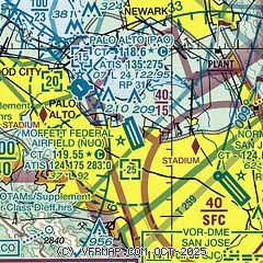
| Sectional chart |
|---|
|
 Download PDF
of official airport diagram from the FAA
| Airport distance calculator |
|---|
|
|
| Sunrise and sunset |
|---|
|
Times for 27-Jan-2026
| | Local
(UTC-8) | | Zulu
(UTC) |
|---|
| Morning civil twilight | | 06:49 | | 14:49 |
| Sunrise | | 07:16 | | 15:16 |
| Sunset | | 17:26 | | 01:26 |
| Evening civil twilight | | 17:54 | | 01:54 |
|
| Current date and time |
|---|
| Zulu (UTC) | 27-Jan-2026 15:34:23 |
|---|
| Local (UTC-8) | 27-Jan-2026 07:34:23 |
|---|
|
| METAR |
|---|
| KNUQ | 271515Z AUTO 00000KT 10SM CLR 05/04 A3025 RMK AO2
|
KPAO
4nm NW | 271447Z VRB03KT 10SM SKC 03/02 A3026
|
KSJC
7nm SE | 271453Z 00000KT 10SM FEW075 SCT120 05/03 A3025 RMK AO2 SLP243 T00500028 51003
|
KSQL
11nm NW | 271500Z 00000KT 10SM CLR 06/05 A3026
|
KRHV
13nm SE | 271455Z 00000KT 10SM SKC 04/03 A3025
|
KHWD
15nm N | 271454Z 10003KT 7SM CLR 06/04 A3025 RMK AO2 SLP252 T00610044 51003
|
KOAK
19nm NW | 271453Z 00000KT 7SM FEW006 SCT250 06/06 A3025 RMK AO2 SLP243 T00610056 51002
|
KSFO
19nm NW | 271456Z 21003KT 10SM FEW006 SCT200 08/07 A3025 RMK AO2 SLP243 T00780067 53003
|
|
| TAF |
|---|
KSJC
7nm SE | 271139Z 2712/2812 21004KT P6SM SCT150 FM271400 18003KT P6SM BKN150 FM272100 20008KT P6SM BKN150 FM280400 14008KT P6SM VCSH SCT020 OVC100 FM280900 VRB03KT P6SM BKN030
|
KOAK
19nm NW | 271139Z 2712/2818 06003KT P6SM SCT200 FM271800 11005KT P6SM BKN200 FM272100 26007KT P6SM BKN100 FM280400 20006KT P6SM SCT020 OVC080 FM280600 21006KT 5SM -RA BR OVC020 FM280900 23003KT 6SM BR BKN020 OVC030 FM281700 02006KT P6SM SCT030
|
KSFO
19nm NW | 271139Z 2712/2818 VRB04KT P6SM BKN150 FM271800 20012KT P6SM SCT050 BKN100 FM280400 23008KT P6SM SCT020 OVC050 FM280600 19006KT 5SM -RA BR OVC020 FM280900 26004KT 6SM BR BKN020 OVC030 FM281700 36007KT P6SM SCT030
|
|
| NOTAMs |
|---|
NOTAMs are issued by the DoD/FAA and will open in a separate window not controlled by AirNav.
|
|


