FAA INFORMATION EFFECTIVE 20 MARCH 2025
Location
| FAA Identifier: | OSC |
| Lat/Long: | 44-27-05.5000N 083-23-39.0000W
44-27.091667N 083-23.650000W
44.4515278,-83.3941667
(estimated) |
| Elevation: | 633.1 ft. / 193.0 m (surveyed) |
| Variation: | 07W (2005) |
| From city: | 3 miles NW of OSCODA, MI |
| Time zone: | UTC -4 (UTC -5 during Standard Time) |
| Zip code: | 48750 |
Airport Operations
| Airport use: | Open to the public |
| Activation date: | 11/1993 |
| Control tower: | no |
| ARTCC: | MINNEAPOLIS CENTER |
| FSS: | LANSING FLIGHT SERVICE STATION |
| NOTAMs facility: | OSC (NOTAM-D service available) |
| Attendance: | SAT-SUN ON CALL, ALL MON-FRI 0800-1700
FOR SVC WKENDS CALL FBO AT 989-739-8486. |
| Wind indicator: | lighted |
| Segmented circle: | no |
| Lights: | ACTVT MALSR RWY 25; REIL RWY 07; PAPI RWY 07 & 25; HIRL RWY 07/25 - CTAF. |
| Beacon: | white-green (lighted land airport)
Operates sunset to sunrise. |
Airport Communications
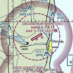
| CTAF/UNICOM: | 123.0 |
| WX AWOS-3: | 118.7 (989-739-1310) |
- APCH/DEP SVC PRVDD BY MINNEAPOLIS ARTCC ON FREQS 125.475/269.45 (OSCODA RCAG).
Nearby radio navigation aids
| VOR radial/distance | | VOR name | | Freq | | Var |
|---|
| APNr177/38.5 | | ALPENA VORTAC | | 116.50 | | 07W |
Airport Services
| Fuel available: | 100LL JET-A+ |
| Parking: | hangars and tiedowns |
| Airframe service: | MINOR |
| Powerplant service: | MINOR |
Runway Information
Runway 7/25
| Dimensions: | 11800 x 200 ft. / 3597 x 61 m |
| Surface: | asphalt/grooved, in good condition |
| Weight bearing capacity: | | Single wheel: | 155.0 | | Double wheel: | 330.0 | | Double tandem: | 550.0 |
|
| Runway edge lights: | high intensity |
| RUNWAY 7 | | RUNWAY 25 |
| Latitude: | 44-26.579120N | | 44-27.603672N |
| Longitude: | 083-24.801218W | | 083-22.498088W |
| Elevation: | 632.8 ft. | | 619.7 ft. |
| Traffic pattern: | left | | left |
| Runway heading: | 065 magnetic, 058 true | | 245 magnetic, 238 true |
| Markings: | precision, in good condition | | precision, in good condition |
| Visual slope indicator: | 4-light PAPI on left (3.00 degrees glide path) | | 4-light PAPI on left (3.00 degrees glide path) |
| Approach lights: | | | MALSR: 1,400 foot medium intensity approach lighting system with runway alignment indicator lights |
| Runway end identifier lights: | yes | | |
| Touchdown point: | yes, no lights | | yes, no lights |
| Instrument approach: | | | LOC/GS |
| Obstructions: | 51 ft. tree, 1557 ft. from runway, 697 ft. right of centerline, 26:1 slope to clear | | none |
Airport Ownership and Management from official FAA records
| Ownership: | Publicly-owned |
| Owner: | OSCODA/WURTSMITH AIRPORT AUTH
3961 E AIRPORT DR
OSCODA, MI 48750-2202
Phone 989-739-1111 |
| Manager: | JACK BROWN
3961 E AIRPORT DR
OSCODA, MI 48750-2202
Phone 989-739-1111 |
Additional Remarks
| - | DEER & LRG BIRDS ON & INVOF ARPT. |
| - | TRML BLDG & PRKG LOT GATE ACES: PRESS V, THEN III & II SIMUL, THEN I. |
| - | FOR CD CTC MINNEAPOLIS ARTCC AT 651-463-5588. |
| - | DURG DALGT HRS SIMUL TAIL MAY EXIST OVR AER 07 & 25. |
| - | TSNT ACFT FLW BLUE CNTRLN ON TWY A & TWY D TO LCT ARPT TRML, FUEL, & PRKG. |
| - | POSS JET BLAST ON TWY A INVOF RESTRICTED PRKG APRON & EAST RAMP. |
| - | POSS SVR TURB OVR JET ENG TEST BLDGS (2). |
Instrument Procedures
NOTE: All procedures below are presented as PDF files. If you need a reader for these files, you should download the free Adobe Reader.NOT FOR NAVIGATION. Please procure official charts for flight.
FAA instrument procedures published for use from 20 March 2025 at 0901Z to 17 April 2025 at 0900z.
IAPs - Instrument Approach Procedures |
|---|
| ILS OR LOC RWY 25 | |
download (272KB) |
| RNAV (GPS) RWY 07 | |
download (260KB) |
| RNAV (GPS) RWY 25 | |
download (273KB) |
| NOTE: Special Take-Off Minimums/Departure Procedures apply | |
download (349KB) |
Other nearby airports with instrument procedures:
6D9 - Iosco County Airport (8 nm S)
Y31 - West Branch Community Airport (36 nm W)
KAPN - Alpena County Regional Airport (38 nm N)
KBAX - Huron County Memorial Airport (44 nm SE)
KGDW - Gladwin Zettel Memorial Airport (55 nm SW)
|
|

Road maps at:
MapQuest
Bing
Google
| Aerial photo |
|---|
WARNING: Photo may not be current or correct
 Photographer = Nick Ortenburger
Pilot = Travis Worthington
Do you have a better or more recent aerial photo of Oscoda/Wurtsmith Airport that you would like to share? If so, please send us your photo.
|
| Sectional chart |
|---|
|
| Airport distance calculator |
|---|
|
|
| Sunrise and sunset |
|---|
|
Times for 11-Apr-2025
| | Local
(UTC-4) | | Zulu
(UTC) |
|---|
| Morning civil twilight | | 06:28 | | 10:28 |
| Sunrise | | 06:58 | | 10:58 |
| Sunset | | 20:12 | | 00:12 |
| Evening civil twilight | | 20:42 | | 00:42 |
|
| Current date and time |
|---|
| Zulu (UTC) | 11-Apr-2025 16:14:50 |
|---|
| Local (UTC-4) | 11-Apr-2025 12:14:50 |
|---|
|
| METAR |
|---|
| KOSC | 111555Z AUTO 17011KT 10SM CLR 08/M05 A3021 RMK AO2
|
|
| TAF |
|---|
KAPN
38nm N | 111120Z 1112/1212 VRB03KT P6SM SKC FM111300 02008KT P6SM SKC FM120000 00000KT P6SM SKC
|
|
| NOTAMs |
|---|
NOTAMs are issued by the DoD/FAA and will open in a separate window not controlled by AirNav.
|
|


